

RyanDe680
-
Posts
1,419 -
Joined
-
Last visited
Content Type
Profiles
Blogs
Forums
American Weather
Media Demo
Store
Gallery
Posts posted by RyanDe680
-
-
Was slated to get some hours of flight training in this Saturday but opted not to. Bad start to the weekend if you’re on a flight in or out.
-
1 minute ago, Cary67 said:
So many models, so many runs, so many flavors. Your bound to find one that tastes good.lol
Well then trust the ICON.

-
 4
4
-
-
Should be a fun weekend. Hope the precip verifies as such. Minus the ice.
-
-
4 minutes ago, ILSNOW said:
NAM still with crazy freezing rain numbers.
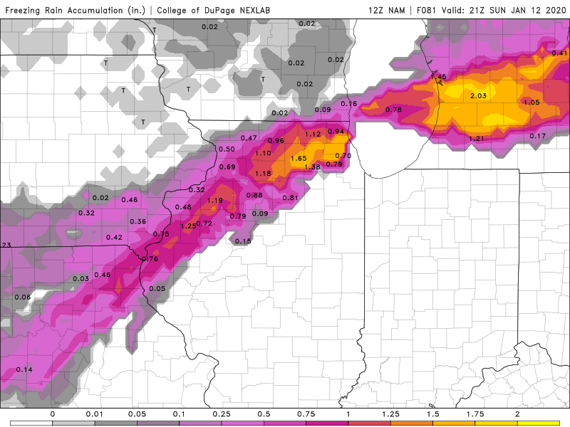
The best case scenario is that none of that verifies
-
Man NAM slowed way down.
Still impressive on 3-4" totals. Sets up a quazi line of storms down the mississippi river from STL down, which would think if better organized would allow moisture to flow north.
-
8 minutes ago, Hoosier said:
Was curious about the last time there was anything even remotely like this at ORD... let's say over 2" precip and some accumulating snow. Well, it was 11/29 to 12/1/2006. 3.42" precip with 6.2" snow.
I strangely remember that. I missed the change over but man it was pouring then.
The QPF numbers on this though for early Jan are still pretty impressive.
-
Crazy precip estimates for this time of year.
-
9 minutes ago, michaelmantis said:
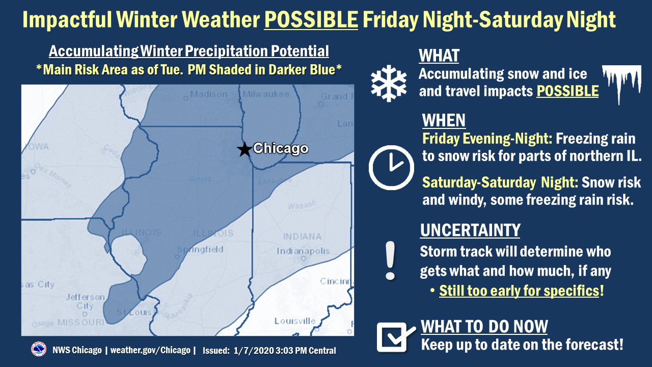
This is purely a "marketing" or "public relations" question, not a criticism of the NWS by any means.
Does publishing an image like the one below (from NWS Chicago a few minutes ago) provide clarity to the general public?
Those of us here are following models, each track shift, freezing lines, and listening to the voices from our voodoo dolls that whisper the weather future, etc. But does the average person get the intended message out of the image below?
Also, what is the key for the two different colors? I get the dark blue is the main risk area, but what is that? 50% chance? This seems to me like some type of NWS model output that is so simplified that is loses meaning.
Once again, mean absolutely no disrespect. Just curious.
More to emphasize the broad range of possiblities.... The avg person should read that as the lighter areas expect impactful travel and in the darker areas, more so but uncertainty as to exactly where this far out...
-
So early, this will be fun to watch over the next 3 days.
Emotions run high.
-
Ugh. Euro off to a good start for the season. Can’t believe we’re talking 3”+ on 11/11.
-
I'll go with 95 - 101 - 94 Thurs - Sat at ORD.
This is honestly better than snow precip.
-
 1
1
-
-
22 hours ago, Hoosier said:
Just want to say thanks to those who offered well wishes following my accident. I have a concussion and cervical strain (whiplash) and have been dealing with the effects of those. The time since July 3 is a blur. I went back and read my post from then and really don't even remember that, but according to the information packet I received sometimes all of the symptoms don't start right away. Lights, including screens, have been bothering me. Fortunately that has largely cleared up but I am still having headaches and difficulty concentrating. My past memories (weather and other) are all there, I think. Like I remember the big storms, getting screwed by sleet in the 2011 storm, and stuff like that. All in all, things are starting to get better but the recovery timetable from the neck strain is up in the air. Could be weeks, could be months.
Looks like Barry will be a big rainmaker down south and it looks like it could get pretty hot around here soon.
Speedy recovery. I hope you heal up soon.
-
Just now, CoalCityWxMan said:
Storm with a pretty healthy hail core moving into the center of the metro
Was just under that. No wind. Heavy rain though (0.25 in about 10 minutes) and penny hail. Decent storm.
-
Slight shift north on the slight risk for today
-
Rain gauge from last month was at 9.8. Hoping June isn’t so wet.
-
This is in Hooiser's neighborhood, no?
-
Storms re-firing along a quasi outflow from the tornadic cell in NE IL
-
1
-
-
1 minute ago, Hoosier said:
Looks like they are not continuing the tornado warning for areas farther east.
Looks to be going into a less favorable environment at this point... Not much cape to be had relative to further west
-
pretty clear where the warm front is
-
Came through here with a bunch of meh rain and nothing else
-
Cell in NE IL is Tornado warned... basically over LOT site
-
some good development to the west / southwest of the warned cell in NE IL
-
I don’t see how the precip in central IL and SE Iowa won’t reduce this opportunity?. Seems that every chance we’ve had recently has been killed by morning convection. Any thoughts around this?

January 10th-12th Winter Storm Potential
in Lakes/Ohio Valley
Posted
I'm hoping for some good photos of 2 story high waves on Lake Michigan