NorthArlington101
-
Posts
12,490 -
Joined
-
Last visited
Content Type
Profiles
Blogs
Forums
American Weather
Media Demo
Store
Gallery
Everything posted by NorthArlington101
-

80 Degrees to Ripping Snow: March 12th
NorthArlington101 replied to SnowenOutThere's topic in Mid Atlantic
Hey, LWX says there is a 1-10 chance of 6” -
80 Degrees to Ripping Snow: March 12th
NorthArlington101 replied to SnowenOutThere's topic in Mid Atlantic
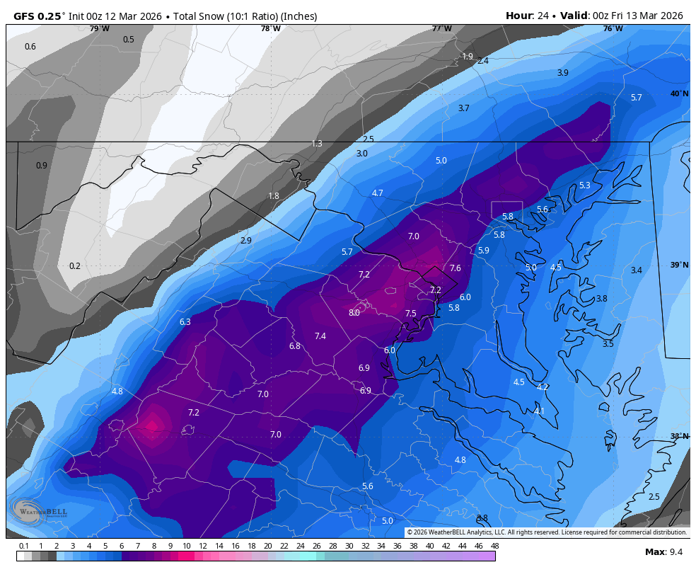
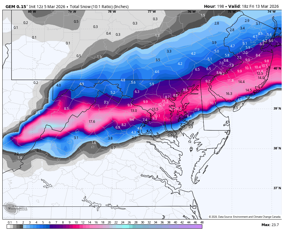
Nice to see the hi-res Canadian onboard for snow falling from the sky.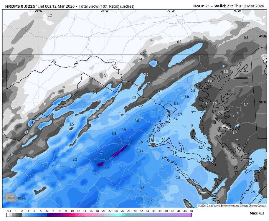
-
80 Degrees to Ripping Snow: March 12th
NorthArlington101 replied to SnowenOutThere's topic in Mid Atlantic
Too good not to post.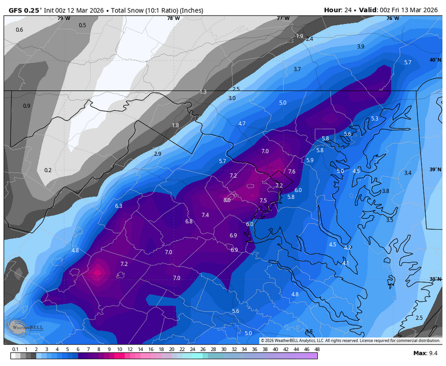
-
80 Degrees to Ripping Snow: March 12th
NorthArlington101 replied to SnowenOutThere's topic in Mid Atlantic
NAMs and FV3 are as nice as you could hope. I’d just like it to rip for an hour or two. That would be sweet. Anything else that could happen is gravy -
80 Degrees to Ripping Snow: March 12th
NorthArlington101 replied to SnowenOutThere's topic in Mid Atlantic
More curious what the even higher rez Canadian says. It was sorta on board last run. -
80 Degrees to Ripping Snow: March 12th
NorthArlington101 replied to SnowenOutThere's topic in Mid Atlantic
HRRR is in for the entire DMV -
EURO has a light/mod event on the 25th. Obviously weeks out but perhaps not a shutout pattern through the end of the month.
-
80 Degrees to Ripping Snow: March 12th
NorthArlington101 replied to SnowenOutThere's topic in Mid Atlantic
I guess you'd expect they would - and I realize they are useless at this range, but EPS look exactly like the OP. Guess it's time to "prep" for a few inches of snow falling - not necessarily sticking -
80 Degrees to Ripping Snow: March 12th
NorthArlington101 replied to SnowenOutThere's topic in Mid Atlantic
EURO gonna be on board again. Maps in a sec -
Nice storm around the 21st, though. Pushed out to sea before we can really get hammered, but we’d all take it I’m sure. Maybe we have a couple shots.
-
Not you too! Bring on one more chance. It ain’t gonna snow for 10 months after that window.
-
Snow TV per surface temps but wouldn’t complain
-
Clearly a window in the period the OP is advertising.
-
Lock it in!

-
12th Annual Mid-Atlantic Snowfall Contest
NorthArlington101 replied to RodneyS's topic in Mid Atlantic
Pretty content with third if this is it. But hope the AIFS is right and I get blown out. -
Outta gas and Outta Time: Early March Winter Storm finale
NorthArlington101 replied to Ji's topic in Mid Atlantic
0.8”! Guess we’ll see ptype on that stuff coming out of the south soon. Expecting a tiny bit of snow to start still IMO but probably glaze up sooner rather than later -
Gonna copy DCA for MBY and go with 1" based on local spotters for Arlington see sig. Average winter pretty much
-
Outta gas and Outta Time: Early March Winter Storm finale
NorthArlington101 replied to Ji's topic in Mid Atlantic
Still some flurries in DC. Want to say like .75” but will wait for some reports. Seems about the same at the Arlington abode. DCA needs .4” to get to 10”. They *should* get it. -
Outta gas and Outta Time: Early March Winter Storm finale
NorthArlington101 replied to Ji's topic in Mid Atlantic
Seems like everything runs mostly west-east until midnight ish - then wave two comes north. Supposed to dry out in between but guess we’ll see. -
Outta gas and Outta Time: Early March Winter Storm finale
NorthArlington101 replied to Ji's topic in Mid Atlantic
Deck firmly coated in DC. Roofs snowy. Pretty out there. -
Outta gas and Outta Time: Early March Winter Storm finale
NorthArlington101 replied to Ji's topic in Mid Atlantic
Coming down real nicely in Downtown DC at this point. Excellent Snow TV -
Outta gas and Outta Time: Early March Winter Storm finale
NorthArlington101 replied to Ji's topic in Mid Atlantic
Yeah - this was well modeled as far as that dynamic band went. Was gonna be a pretty decent screw job just south of it and... oh well. Stuff to the south looks much beefier than modeled though. Just need it to climb. Not sure it will. -
Outta gas and Outta Time: Early March Winter Storm finale
NorthArlington101 replied to Ji's topic in Mid Atlantic
Yep - flurries at least. Need the stuff south to push up. -
Outta gas and Outta Time: Early March Winter Storm finale
NorthArlington101 replied to Ji's topic in Mid Atlantic
It's a classic DC snowstorm look for inexplicable reasons. -
Outta gas and Outta Time: Early March Winter Storm finale
NorthArlington101 replied to Ji's topic in Mid Atlantic
Woes of employment. I barely get a window. Radar says it's coming. Patience is a virtue (that I don't have).