NorthArlington101
-
Posts
12,431 -
Joined
-
Last visited
Content Type
Profiles
Blogs
Forums
American Weather
Media Demo
Store
Gallery
Everything posted by NorthArlington101
-

January 2026 Medium/Long Range Discussion
NorthArlington101 replied to snowfan's topic in Mid Atlantic
Sporadically on his remaining channels. I'm not actually in any of them - just get them shared through the grapevine and try to pass them along here. Was honking late Jan - early Feb as his favorite period since Jan 2022. -
January 2026 Medium/Long Range Discussion
NorthArlington101 replied to snowfan's topic in Mid Atlantic
This is the HM storm... -
January 24-26: Miracle or Mirage Thread 2
NorthArlington101 replied to mappy's topic in Mid Atlantic
I don't have Kuchera maps but widespread 10-15" - dc sorta gets holed somehow but it's fine. -
January 24-26: Miracle or Mirage Thread 2
NorthArlington101 replied to mappy's topic in Mid Atlantic
Flips the sleet lever a little earlier anyway. Still should be a fine run. -
January 2026 Medium/Long Range Discussion
NorthArlington101 replied to snowfan's topic in Mid Atlantic
-
January 24-26: Miracle or Mirage Thread 2
NorthArlington101 replied to mappy's topic in Mid Atlantic
At minimum all of this is snow on the GFS AI: Most of us lose 700mb by a hair between 72-78... where totals jump to this. Lot of sleet after. -
January 24-26: Miracle or Mirage Thread 2
NorthArlington101 replied to mappy's topic in Mid Atlantic
Warmest surface temps I can find. No matter what Ptype, this is gonna be pretty sick at least. Really hard to do this around here. -
January 24-26: Miracle or Mirage Thread 2
NorthArlington101 replied to mappy's topic in Mid Atlantic
Correct: -
January 24-26: Miracle or Mirage Thread 2
NorthArlington101 replied to mappy's topic in Mid Atlantic
-
January 24-26: Miracle or Mirage Thread 2
NorthArlington101 replied to mappy's topic in Mid Atlantic
GFS is a 1’+ for everyone, and I pretty much mea everyone. Hope it’s doing okay thermal wise. Nice to see the hires FV3 also chilly. -
January 2026 Medium/Long Range Discussion
NorthArlington101 replied to snowfan's topic in Mid Atlantic
The period HM was honking wasn't the storm this weekend really... it was next week and the first week or so of February. Food for thought. -
January 24-26: Miracle or Mirage Thread 2
NorthArlington101 replied to mappy's topic in Mid Atlantic
Warm layers can 100% race north quickly, though I'm still not gonna worry about NAM ptype until tomorrow at 06z at earliest -
January 24-26: Miracle or Mirage JV/Banter Thread!
NorthArlington101 replied to SnowenOutThere's topic in Mid Atlantic
From my 4 years in Cville... it can hang on a bit more with the CAD. Honestly, I think you'll do fairly similar to a lot of NOVA on this storm, though that take might age badly. Don't think you really sleet that much more, think you turn to sleet sooner but also start a bit sooner. Really significant FRZA seems increasingly unlikely to me. Feel like it's snow -> sleet for most of us. -
January 24-26: Miracle or Mirage JV/Banter Thread!
NorthArlington101 replied to SnowenOutThere's topic in Mid Atlantic
One day you have to go outside of work hours! I think we've had this convo before, but I live fairly close to Other Half in Ivy City. Come to Succotash today too Not as beer-adventurous as Other Half, but it'll be fun. -
January 24-26: Miracle or Mirage JV/Banter Thread!
NorthArlington101 replied to SnowenOutThere's topic in Mid Atlantic
I've been telling people to always leave an inch or so at the bottom so nobody is trying to straight shovel sleet. Figure most folks won't be starting at CC radar and wanted to keep the advice generic. -
January 24-26: Miracle or Mirage JV/Banter Thread!
NorthArlington101 replied to SnowenOutThere's topic in Mid Atlantic
@yoda something in your settings says you can't receive PMs - hoping to see you (and anyone else here) at Succotash DC sometime between 5-7pm! I'll be in a pink button-down. If anyone wants to join and wants my cell #, message me. -
January 24-26: Miracle or Mirage Thread 2
NorthArlington101 replied to mappy's topic in Mid Atlantic
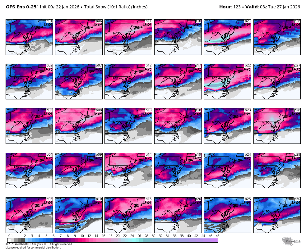
Don’t think a single GEFS member is <6” at DCA. Going to bed with hope - good luck with the EURO!
-
January 24-26: Miracle or Mirage Thread 2
NorthArlington101 replied to mappy's topic in Mid Atlantic

-
January 24-26: Miracle or Mirage Thread 2
NorthArlington101 replied to mappy's topic in Mid Atlantic
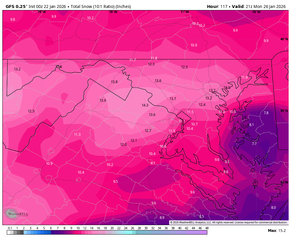
UKIE like 15”+ 10:1 -
January 24-26: Miracle or Mirage Thread 2
NorthArlington101 replied to mappy's topic in Mid Atlantic
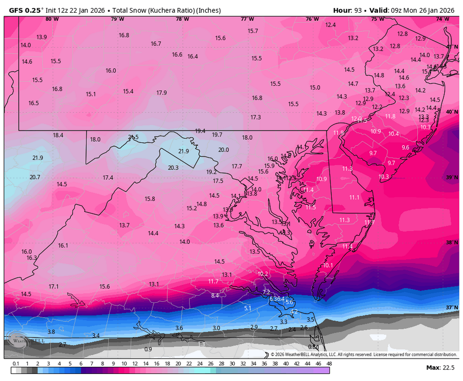
93 on UKIE sleet approaching -
January 24-26: Miracle or Mirage Thread 2
NorthArlington101 replied to mappy's topic in Mid Atlantic
Crushed from 84-90 -
January 24-26: Miracle or Mirage Thread 2
NorthArlington101 replied to mappy's topic in Mid Atlantic
UKIE gonna stay in the good camp. Solidly snowing at 84 with the mix line still down near RIC -
January 24-26: Miracle or Mirage Thread 2
NorthArlington101 replied to mappy's topic in Mid Atlantic
We already saw the RGEM so we’ve basically seen the CMC. 6-8” thump then we mix. Hopefully that’s the floor. -
January 24-26: Miracle or Mirage Thread 2
NorthArlington101 replied to mappy's topic in Mid Atlantic
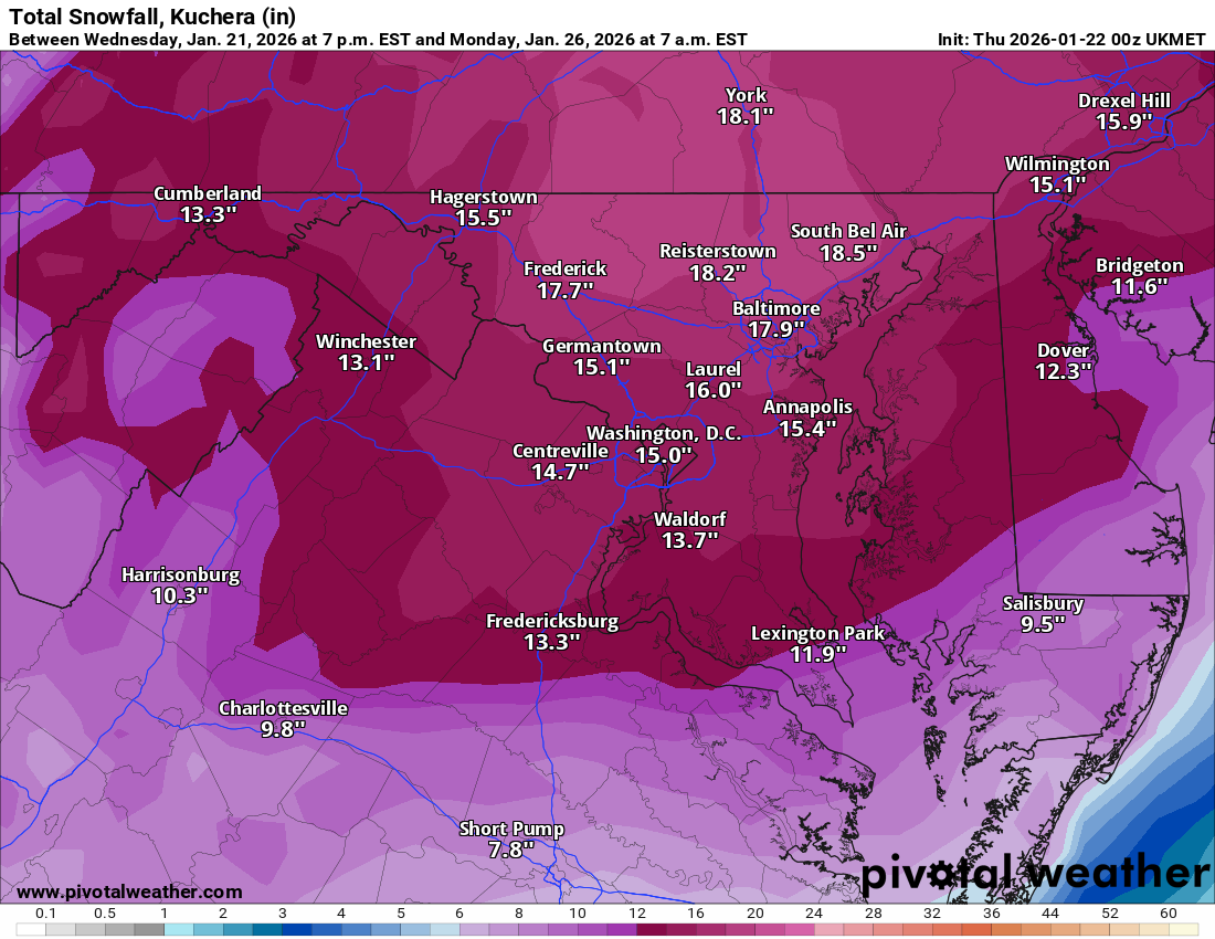
10:1 if you are a ratio skeptic. Also was probably .5” more on the other Kuchie maps. Whoops.
-
January 24-26: Miracle or Mirage Thread 2
NorthArlington101 replied to mappy's topic in Mid Atlantic
In theory, yes. I’d tag @high risk for confirmation