

radarman
-
Posts
13,203 -
Joined
-
Last visited
Content Type
Profiles
Blogs
Forums
American Weather
Media Demo
Store
Gallery
Posts posted by radarman
-
-
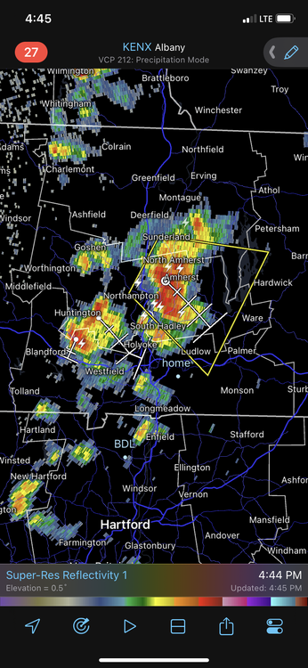
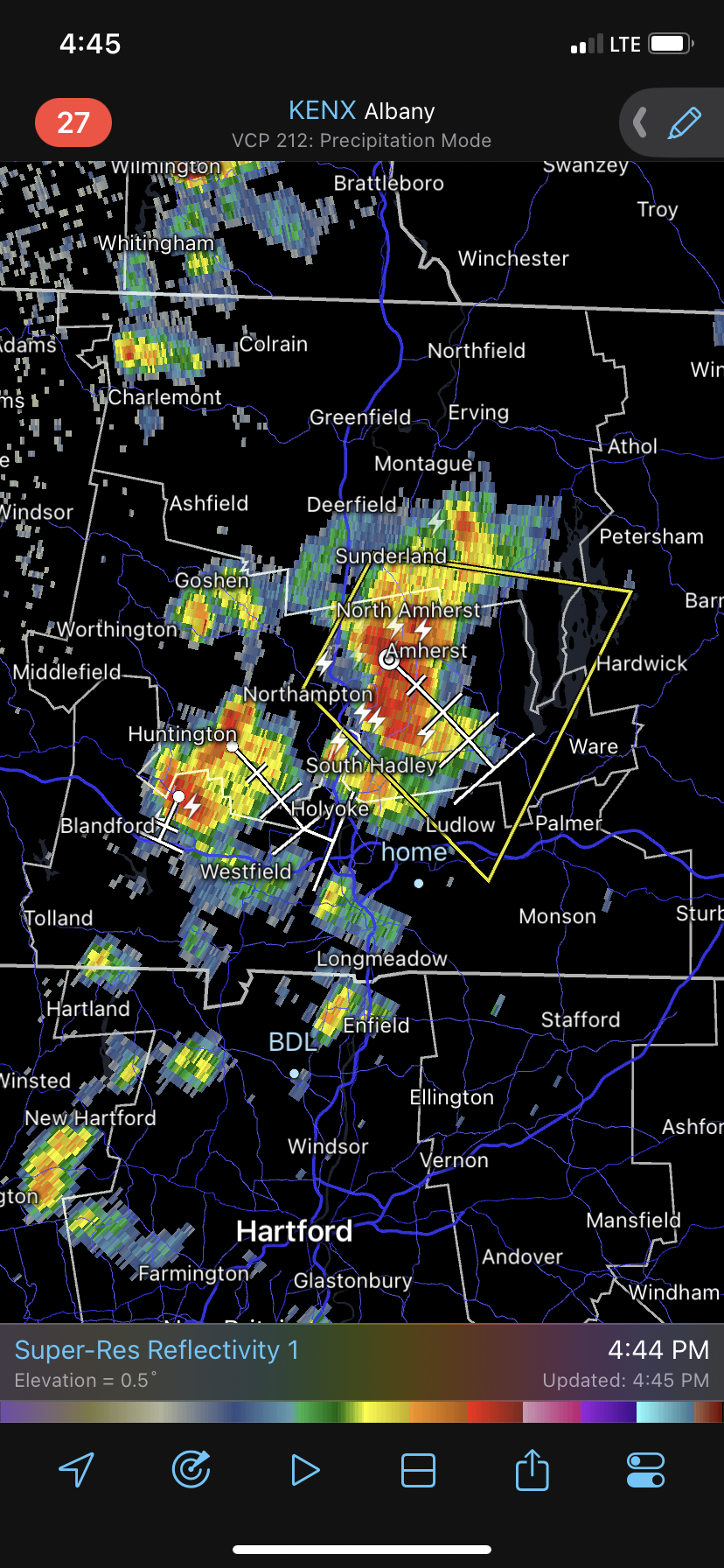
We'll see if BAF can verify a severe gust here shortly.
-
2 minutes ago, ineedsnow said:
Was just about to post that I think that's the storm I'm going for
If you're coming from up north I'd tuck tail and go east of the Quabbin for an intercept later on. I'm thinking not much will come of this present stuff this far west.
-
 1
1
-
-
a little cell popped between Amherst and Btown. Nothing to speak of just yet, but that's the type of thing that would need to be watched in about 15-20 mins, particularly if it becomes a right mover. Whether it's this particular cell or one like it.

-
2
-
-
that EEN cell looks like a hail producer
-
1 hour ago, weatherwiz said:
I wonder if storm mode was a big driver in SVR vs. TOR
You can kind of see evidence of 1-3 embedded supercell like structures out in the Berks back into the HV, but it'll probably transition to a truly linear system pretty soon. Mainly a wind threat, localized QLCS possibilities aside. We'll see if anything pops out ahead.
-
2 minutes ago, CoastalWx said:
The other thing is a deamplifying s/w and not really any height falls.
this plus a good chunk of overcast and folks should be happy there's no EML
-
1
-
-
All these fake model soundings I'm looking at are a bit weak with the low level winds. But they do improve a bit as you head toward E CT/RI and adjacent MA. Thinking primarily a straight line threat out here... which'd be about the only notable winds we've had all season. But maybe a little more than that further SE.
-
2 hours ago, ineedsnow said:
Tornado Warning
NYC111-160915-
/O.NEW.KALY.TO.W.0005.230716T0850Z-230716T0915Z/

BULLETIN - EAS ACTIVATION REQUESTED
Tornado Warning
National Weather Service Albany NY
450 AM EDT Sun Jul 16 2023

The National Weather Service in Albany has issued a

* Tornado Warning for...
  Northeastern Ulster County in east central New York...

* Until 515 AM EDT.

* At 450 AM EDT, a severe thunderstorm capable of producing a tornado
  was located over Hurley, or near Kingston, moving northeast at 20
  mph.

  HAZARD...Tornado.

  SOURCE...Radar indicated rotation.
Just noticed this thread... I'm in Kingston and woke up to WEA tornado warnings about 25 mins ago. Fully embedded couplet was easy to track over time. Missed me to the west a bit but it wouldn't surprise me if there were some light damage in town somewhere.
-
2
-
-
Seems like a friendly guy
-
Made a weenie pilgrimage to Xenia OH today. Was hoping for severe but it mostly went south along the floor of the OV.
Anyway... good luck back home.

-
5
-
-
1 hour ago, BrianW said:

These have nearly the same diurnal range as the surface temp sensors. Seems a bit odd. Or maybe it's normal, not sure.
-
In the winter an outcome like this is nightmare stuff here... today we take.
Those pics out of VT are horrific.
-
2
-
-
1 hour ago, HIPPYVALLEY said:
I’m a little concerned about Vermont. The rivers and streams are already running high there with saturated ground.
Just spoke to my uncle who runs a small hydro in C VT... he said the flow at present is equal to his May 1st climo in 40 years of data collection.
-
1
-
-
1 minute ago, HoarfrostHubb said:
We were at Tree House in Tewksbury last night. There was a decent breeze. I noted it because it has been pretty still for quite a while
Nice, I heard they were officially open. I finally made it to the Deerfield taproom not that long ago and the work they do is always impressive. Hoping to get to Sandwich at some point also.
-
1
-
-
1 minute ago, Ginx snewx said:
Nice breeze today. I think I spent maybe 4 hrs each afternoon in the water. Ocean was outstanding Wed,surf was blown out but water was azure blue not a hint of seaweed.
Hit Long Sands in York yesterday morning, 10AM low tide and the sun poking out on the edge of a cloud deck. Light east breeze felt great and the water was clean and tolerably warm. Smallish waves but they roll onto that beach perfectly. Unfortunately the same easterly breeze brought in some heavier fog by noon so it was an abbreviated session, but still nice to get to the coast.
-
2
-
-
8 minutes ago, HIPPYVALLEY said:
What good is summer warmth when it rains every day? Brutal.
Even aside from the rain, the humid overcast and total lack of breeze is the absolute worst.
-
4
-
-
Areal flooding definitely in play along the small rivers and streams, not just flash flooding. Base flow is already way high for this time of year. Heck even the CT is up, walked over the bridge yesterday to check it out. Looks like April levels. Let's not have any big wet TS this year thanks.


-
2
-
-
46 minutes ago, weatherwiz said:
Of course I go to Hartford and
You didn't miss anything interesting. Every storm has been a garden variety storm.
-
 1
1
-
-
Flood watches hoisted for good chunks of MA, NECT, NWRI
-
1
-
-
1.1" so far today
-
1
-
-
3.2" on the nearest online PWS so far. Not sure why I haven't bought a stratus gauge yet.
-
1
-
-
2 minutes ago, weatherwiz said:
Thunder...either from the cell to the northeast near Belchertown or to my southeast or Hampden or even to my west...I'm a cell sandwich AGAIN FOOK THIS.
my wind comments aside, I can verify that the storm that just came through had quite a bit of electrification
-
1
-
-
It's been hit and miss on these thunderstorms the last few days, today more hit than miss, with some heavy downpours out of nothing cells. But in terms of wind it's been 100% meh, I can't recall a more boring start to the severe wx season here in Btown, aka the ICT of SNE. Maybe southern portions of the east slope got a half decent storm the other day.
-
4 minutes ago, CoastalWx said:
Wow
This
That's how you FF
Thursday, July 27, 2023 Severe Weather Potential
in New England
Posted
57 kts BAF
not shabby
KBAF 271958Z 25030G57KT 1 1/4SM R20/4000VP6000FT -TSRA SQ FEW013 SCT060 SCT090 28/22 A2989 RMK AO2 PK WND 24057/1956 LTG DSNT ALQDS RAB58 PRESRR P0010 T02780217