

radarman
-
Posts
13,100 -
Joined
-
Last visited
Content Type
Profiles
Blogs
Forums
American Weather
Media Demo
Store
Gallery
Posts posted by radarman
-
-
We were 19 this AM, meanwhile the east slope is low 30s.
Gorgeous sunrise
-
I like that at the surface we have almost a SWFE event like retreating HP situation that might provide some resistance, lest that jet ushers things away too fast. All the same, I'm expecting a fairly quick hitter.
-
Start snowing Saturday evening out here, sun by first chair?
-
17 minutes ago, CT Rain said:
Might as well just stay in Dallas, right?
I'm flying into DFW on Sunday.
April is an awesome time to be there that's for sure.
-
The sun was a very welcome sight this afternoon. Quite pleasant out, finally.
-
 1
1
-
-
3 minutes ago, CoastalWx said:
Gfs was close but not biting. We watch.
1 minute ago, CoastalWx said:Gfs wasn’t bad looking on the 8th either at this stage.
coastal areas favored, but agree on both. Things are looking up IMO. Folks need to let these last few passing showers wash them clean of 2023.
-
Just booked to Springfield OH and will proceed N from there.
Texas would be better but good luck to anyone trying to drive out to totality from the metroplex. That's gonna be a sh*tshow to say the least.
-
until the 300+ hr op gfs prints out a bomb, the pattern change isn't happening
-
2
-
 1
1
-
 1
1
-
-
11 minutes ago, DJln491 said:
Euro didn’t bite
7 minutes ago, NW_of_GYX said:It just doesn't snow in SNE anymore. Clown map yes, SNE snow weenies bridge jumping also yes.
The sooner SNE folks toss December and embrace AOB temps to kick off Jan... ignore clown maps and track the possible developing -EPO ridge with signs of split flow and an STJ... the better for all.
-
1
-
-
Dec 2015 was the second warmest on record at INL (soon to be 3rd). Also featured well BN snows. Figure some additional amount of climate warming, plus the (solar max related?) AO spike the last 2+ weeks, with a particularly hostile pacific and here we are. Certainly smashing a record by that much is noteworthy, but the cards appeared to be stacked against them from the get go this December.
-
I swear it isn't a matter of schadenfreude when I say that should the skiing out west be lackluster this year, after the true epicosity that was last year, I can't get too worked up about it.
That said I was happy to see powder alert emails showing up in my mailbox yesterday from Sugar Bowl.
-
1
-
-
Berkshire East is open today and probably skiing pretty good on limited terrain. You give these places 36-48 hours to blast the guns and the surfaces improve immensely. With climo rapidly improving, even marginally BN nights and dry days will make for rapid expansion in the 1st week of Jan. Skiers were treated to a high end December up north, now we move onto carving and winter conditions.
-
1
-
-
Post rainstorm pattern as depicted looks ideal for pond ice formation. Shades of similarly snowless early Jan 2015.
Edit- referring to the ice and the timing, not the pattern.
-
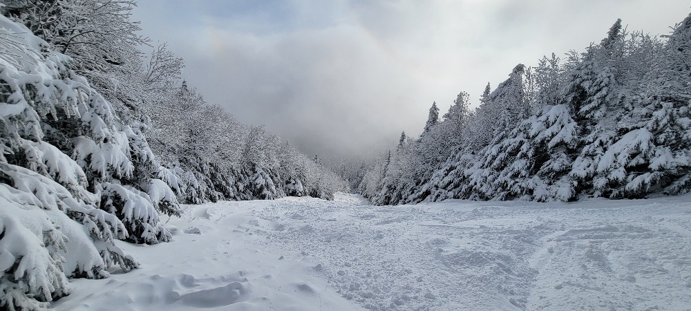
4 hours ago, powderfreak said:
The scenes in general don’t really get any better in New England for winter vibes.
Agree. Times like these the skiing almost becomes secondary and the main attraction is just being there wandering around.
-
5
-
-
Love kicking off the season getting straight into the good stuff.
-
9
-
-
MRG announced opening on Thursday. Also keeping an eye out for the Mt Ellen uphill opening, really hoping they announce it tonight. Tomorrow looks primo. Even if not LP is allowing Castlerock access as of today, which wouldn't be a bad consolation prize.
-
2
-
-
I grew a ponytail just for this and now you're telling me it's not happening?
-
3
-
-
33 minutes ago, Ginx snewx said:
? Wait I mean skiing wise
Yeah... it's not even close to 18 skiing wise. Sugarbush mid mountain had like 90" that month, and even in S VT we were skiing in 4' of pow at Magic, 100% open and in peak condition on 11/29.
-
FWIW my wife hit a deer and totaled her car a couple years ago and Plymouth Rock was fine. No issues, cut a check for the full value promptly, and gave her a good price. Granted the situation was pretty cut and dry, what with the fur still embedded in the vehicle and whatnot. Maybe more murkier situations of who's at fault are where the differences between companies show up?
-
the -3 novie with snow accums felt winter like at times. Not a complete loss.
-
1
-
-
23 minutes ago, Ginx snewx said:
Reminds me of 18.
A very poor man's version of such, but maybe best since?
-
Back to QC for a second... tell me the NOWdata high temps for all the coop sites in SNE isn't 10 degrees too high across the board yesterday (11/28). It's weird.
-
2 hours ago, ORH_wxman said:
The empirical evidence for ORH running too warm is overwhelming. I’m not sure how you can look at data for more than a few minutes and conclude otherwise. Even if you do not trust MADIS, just compare sthe ORH monthly departures to other first order climate stations in SNE and you’ll see consistently that ORH runs warmer. They are also consistently warmer than just about every single mesonet site at similar elevation near them. I’ve looked at this extensively since discovering the issue.
Here’s the MADIS graph on a longer timeline. Pretty obvious step change in 2020 that also aligns with ORH’s divergence from other first order sites on monthly departure
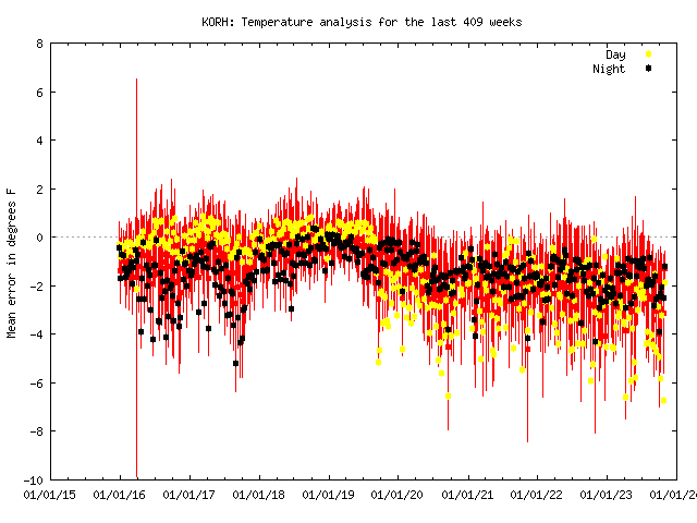
Not disagreeing with the idea that it's running hot, but could the fact that it's effectively a hilltop location factor in? I feel like this year especially we've had decent radiating conditions at times but not a lot of CAA. Are there any other trustworthy coops similarly situated relative to the surroundings? What say KTOL?
-
1
-
-
1 hour ago, HIPPYVALLEY said:
Nothing in Greenfield but there’s a coating of snow on the ground down in Deerfield so they must’ve gotten snow showers overnight or this morning.
Had a quarter inch overnight here. We'll see if that LES band out in NYS can hold together this afternoon. Trajectory looks decent if so.

January 2024 -- Discussion
in New England
Posted
nammy starting to pick up on Kev's snow for tomorrow predawn?