

radarman
-
Posts
13,100 -
Joined
-
Last visited
Content Type
Profiles
Blogs
Forums
American Weather
Media Demo
Store
Gallery
Posts posted by radarman
-
-
IMO from the very beginning this has been a quick hit, blow the fluff off your car in 10 seconds with a leafblower, kind of beautiful sparkly small January event that we don't get any more.
-
 1
1
-
-
17 minutes ago, ORH_wxman said:
1/28/10 was the one you're prob thinking of. That was an epic setup. We're not repeating that since winds are too much westerly component in this one, but there def could be some pretty good squalls.
that was the big one we all remember. We had the poor man's version of that on 1/30/19. Maybe this could be the homeless man's version?
-
1
-
-
9 minutes ago, CoastalWx said:
wow
that is nuts
-
1
-
-
Echoes funneling right up the center of the valley, but not too much here on the outskirts so far. About .2"
-
2 minutes ago, HIPPYVALLEY said:
What did you get in the March paste job last year?
8"
Major elevation and some latitude gradient
-
24 minutes ago, Ginx snewx said:
Crushed
Biggest storm since Dec 2019 here
-
3
-
-
11.75" average otg, still snowing.
-
2
-
-
10.5" otg and borderline sn+ continues
-
4
-
-
10 minutes ago, met_fan said:
11 inches so far in Easthampton
Was that your report or the one on the PNS? That's a really nice big number for the valley bottoms there.
-
46 minutes ago, ineedsnow said:
How much you get in good old Belchertown?
7" here
Not complaining locally
-
3
-
-
9 minutes ago, HIPPYVALLEY said:
Wow, only 2.5” back this way and we never got into +SN bands. My NWS forecast was 8-12” so take that down.
30F with a few stray flakes right now.
Webcams at Berkshire east look like maybe 1 to 2 tops? What a hideous fail. And radar looks like total sh*t too.
I think that 12z nam run from yesterday might have hinted at it, but no modeling can claim victory.
-
1
-
 1
1
-
-
27 minutes ago, ariof said:
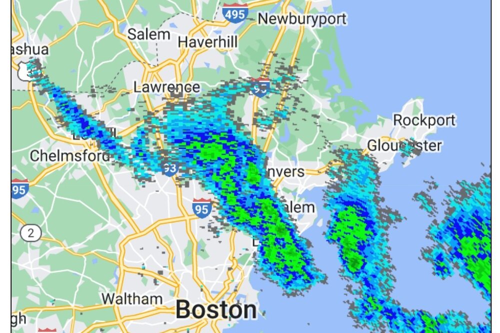
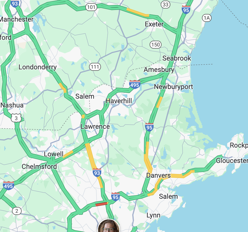
Nothing on radar but quite clearly SN north of Boston on the traffic map.

-
let's get that little clipper to blow up in the aftermath of the cutter and shift the baroclinic zone southeast for the next one
-
1
-
-
16 minutes ago, STILL N OF PIKE said:
Reggie Jackson milder , huggier
brought October with him
-
1
-
-
It's a better capture but the WAA part gets muted out here with snow arriving several hours later. LP initially is out by the convection allows dry air to nose into the midlevels. We'd virga for quite a while.
-
-
12 minutes ago, dendrite said:
This run has sleet up to NH lol
Point and click soundings suggest that hydroclass algorithm might need some work. There might be dry air in the DGZ, but the column is cold in some of those areas, even the warm(er) layers aren't all that warm.
-
1
-
-
yep, those are for nowcast time
-
2
-
-
With so much competition for windblown glop, we should be allowed to claim crystalline feathers falling straight down all to ourselves.
-
 1
1
-
-
Word to the wise... If Berkshire East gets a foot+ of light snow, don't go hard charging under the new quad. Danger is lurking. Seriously.
That said, the surfaces on the snowmaking trails has been exceptionally good considering, guns have been blasting, and the next 4 days should all be worth the trip.
-
2
-
-
16 minutes ago, CoastalWx said:
Tetris??
they probably use some kind of IDW method to smooth it, but it breaks if they're averaging in zeroes from gridcells over the ocean, so they just crop the coastline where those could factor in.
-
3
-
-
I'd go 6-10" in the Pioneer Valley. We always have our red flags and failure modes, but for the most part we've been in the middle of guidance for a while, so might as well be bullish.
-
Watches up
CTZ002>004-MAZ002>014-026-RIZ001-003-050930-
/O.NEW.KBOX.WS.A.0001.240106T2100Z-240108T0600Z/
Hartford CT-Tolland CT-Windham CT-Western Franklin MA-
Eastern Franklin MA-Northern Worcester MA-Central Middlesex MA-
Western Essex MA-Eastern Essex MA-Western Hampshire MA-
Western Hampden MA-Eastern Hampshire MA-Eastern Hampden MA-
Southern Worcester MA-Western Norfolk MA-Southeast Middlesex MA-
Northern Middlesex MA-Northwest Providence RI-Western Kent RI-
Including the cities of Hartford, Windsor Locks, Union, Vernon,
Putnam, Willimantic, Charlemont, Greenfield, Orange, Barre,
Fitchburg, Framingham, Lowell, Lawrence, Gloucester,
Chesterfield, Blandford, Amherst, Northampton, Springfield,
Milford, Worcester, Foxborough, Norwood, Cambridge, Ayer, Foster,
Smithfield, Coventry, and West Greenwich
327 PM EST Thu Jan 4 2024
...WINTER STORM WATCH IN EFFECT FROM SATURDAY AFTERNOON THROUGH
LATE SUNDAY NIGHT...
* WHAT...Heavy snow possible. Total snow accumulations of 6 to 12
inches possible. Winds could gust as high as 40 mph.
* WHERE...Portions of northern Connecticut, central, eastern,
northeastern and western Massachusetts and northern Rhode
Island.
* WHEN...From Saturday afternoon through late Sunday night.
* IMPACTS...Travel could be very difficult. Snow loading from
heavy wet snow may lead to power outages.
* ADDITIONAL DETAILS...Heaviest snow most likely north and west of
the I-95 corridor.
PRECAUTIONARY/PREPAREDNESS ACTIONS...
Monitor the latest forecasts for updates on this situation.
-
Even final totals aside, the idea of waves and waves of mid-level induced bursts with light weenie snows in between is very appealing right now. Something to be embraced after the stretch we've had.
-
3
-

Monitoring some form of significant ( to be determined more precisely) impact winter storm, Jan 16/17th. Moderate seems to be the upper limit - for now
in New England
Posted
The only thing I can think of is that they consider even that scenario a loss, because one euro run got into the sauce and tore a hole in the atmosphere like 3 or 4 days ago.