

radarman
-
Posts
14,474 -
Joined
-
Last visited
Content Type
Profiles
Blogs
Forums
American Weather
Media Demo
Store
Gallery
Posts posted by radarman
-
-
1 hour ago, kdxken said:
Unfortunate. I enjoyed your posts. Stop in once a year when we have a convection threat.
I was on eastern Long Island the weekend before last and they got absolutely rocked with severe on the 4th of July. Damage in every yard, with multiple measured gusts of 87. I saw Hartford (edit Bristol) got 3" hail that day too. Better than anything I've seen nearby this spring. BTown has been hit a few times too as usual.
Anyway I'm still involved in running the UMass radar and following wx back there closely.
-
 4
4
-
 1
1
-
-
4 minutes ago, Damage In Tolland said:
This winter it’s entirely possible you get more snow than we do !
Very, very doubtful. Maybe some TORs here though, 12/26/15 featured a violent EF4 in DFW.
S Rockies hopefully will cash in on Nino climo, not too far of a flight / drive from here to N NM and SW CO.
-
2 hours ago, Damage In Tolland said:
Did @radarmanmove to Texas ?
Yes in April and we'll see for how long. "Enjoying" low 100s this week, but headed back to the valley and maybe get a beach day on the cape this weekend. We still haven't been as hot as what SNE has been this year, and much less humid and smoky too. Plus the super nino might take some of the sting off missing winter.
-
3
-
1
-
-
1 hour ago, jbenedet said:
I planted Texas grass seed in my full sun spots for a reason…
No guarantee it gets that hot down here (Ft Worth) this summer.
-
2 hours ago, metagraphica said:
Sold the house in Salem. Moving to Thailand. Wife (she's from Thailand) and I built a retirement home there about 4 years ago. No more snow for me. 100% AHATT
Congrats, post pics
-
1
-
-
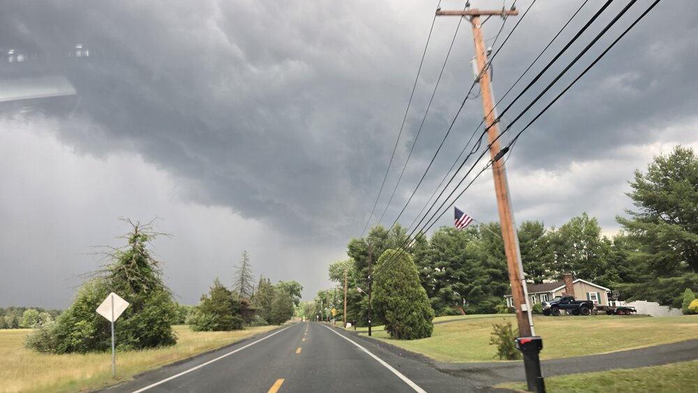
3 minutes ago, weatherwiz said:
Back end view of the cell to the north
from 202 in Granby/Btown
-
3
-
-
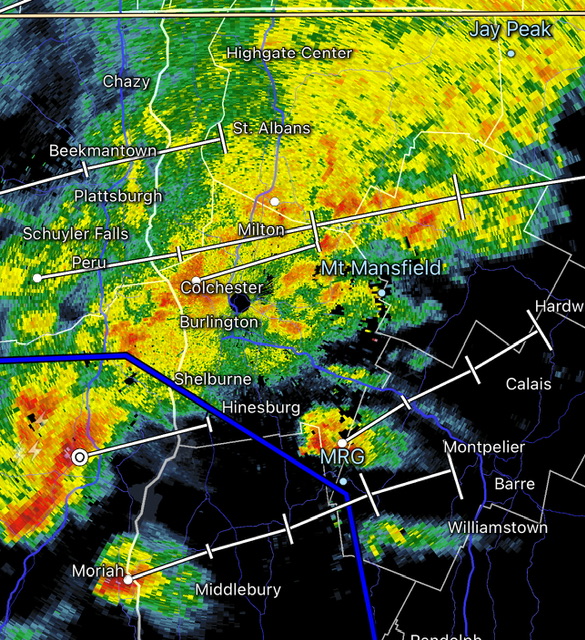
Positive bust on coverage in this part of the valley. Aesthetic too, just not severe.
-
1
-
-
Ski resort tycoon game based on the NELSAP site
-
 1
1
-
-
Heading back to W MA this morning after moving to TX for business reasons. Could be the most exciting wx I've seen all spring. With the nino we've had great lapse rates down there several times but hardly any shear. Now we'll see if the opposite can produce. Local pockets might be able to come up with a small amount of surface instability in the valley, kind of hope the line shows up a bit later than progged.
-
2
-
-
31 for the low. Beautiful nonetheless. Sunny, birds chirping. Buds starting to open up into a light green mist in the canopy.
-
The big blue circles that appear quickly are absolutely ducting effects in general. But the bird signal tends to be buried in that noise because they aren't usually flying all that high off the ground and also because they roost at night and take off in the morning when the inversions are most pronounced. The reflectivity levels they produce are often pretty low because even though they are solid with a decent cross-section there aren't all that many of them (usually) in a volume of air compared to say droplets in moderate rain. Close to the radar where the measured volume sizes are smaller they'll be brighter. Also, the correlation coefficient is lower compared to rain based on the random orientation of their wings and asymmetric shape.
Anyway I've met those guys and a few times I did get the sense that they were mistaking radar artifacts for birds but that would be the data in which you'd be looking for birds.
-
2
-
-
14 minutes ago, powderfreak said:
The afternoon turned out surprisingly nice. It’s always crazy to ski when it’s that mild and humid. Snowpack crying for its mama.
This outta help, ha.
Yeah, it's over. Good luck making it to Sunday. Groomers can do magic but I had two locals tell me today was their last day.
-
1
-
-
Then hit up Treehouse Deerfield on this warm July night, packed. Folks in short shorts outside. 80 degrees still my goodness
-
3 hours ago, powderfreak said:
We’ve hit 75F for a max so far.
Finally gotten in on the fun.
Awesome day up your way, fair amount of fog shifting around run to run but super chill with a good bunch of peeps. Hayride skiers right might have been my fave
-
1
-
-
3 minutes ago, powderfreak said:
That is impressive.
I'm headed up to Stowe tomorrow for one last day, hopefully can keep the rain away until after the lift closes.
-
1
-
-
Mostly cloudy all day at CEF and still hit 87 on 4/15

-
2
-
-
1 hour ago, Damage In Tolland said:
So warm and summery. Man do I love this . Two more days
This has been awesome, no doubt
Just the right amount of dews
-
2
-
-
It's pretty annoying when BOX and ENX are both range folding right over us when the strongest cell in the area is here. As was the case this evening.
-
1
-
1
-
-
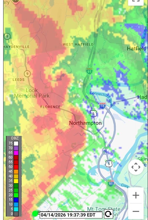
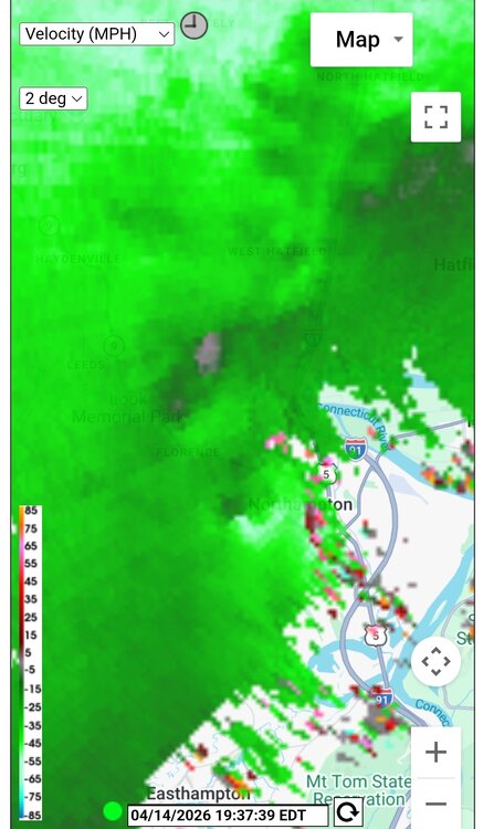
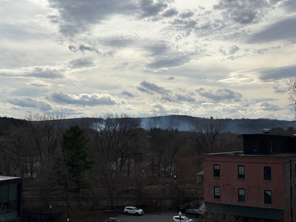
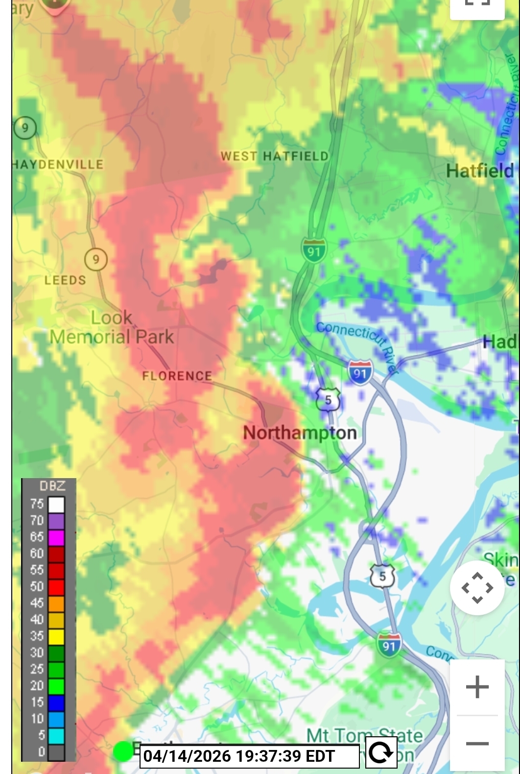
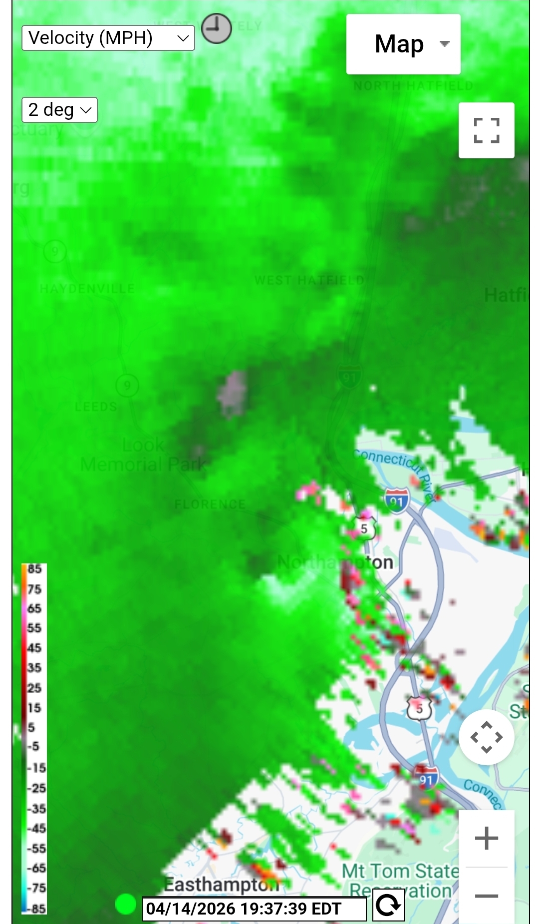
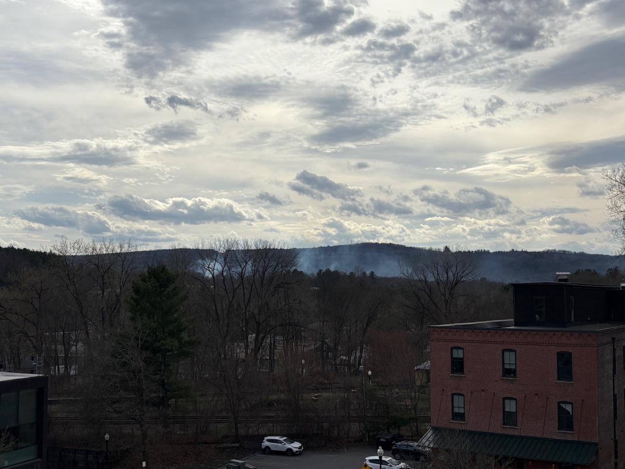
The UMass X band has been performing great of late after some upgrades. Nice to have some high res looks at convection again, this far from Nexrad. You can see the shear tightening up just west of Noho. Doubt this amounted to anything but still cool.
-
6
-
-
37 minutes ago, CoastalWx said:
Wind looks good on radar
Was kind of meh. Good rain though for the plants.
-
1
-
-
2 hours ago, HIPPYVALLEY said:
There might be one near here because I am smelling smoke very strongly.
Edit- 11 acres burned yesterday near the Amherst/Pelham/Btown lines
-
2
-
-
36 minutes ago, weathafella said:
I love how Anthony can’t post anything inside of d10 for winter hope….and now we’re nearly into May. When was the last time NYC had snow that late? I remember a 2-4” event in April 1956.
5/9/2020 had snow in Central Park, which is nuts
-
1
-
-
Stiff NW breeze off the water at Quabbin, and yet still a warm breeze
-
47 minutes ago, Ginx snewx said:
Sacrilege
10M+ households ain't terrible
-
1
-

Ju-ply 2026 Obs and Disco - Kicking it off with heat, humidity, and ... severe?
in New England
Posted
That's gonna feel good after my 106 high and 84 low yesterday at AFW