

radarman
-
Posts
13,100 -
Joined
-
Last visited
Content Type
Profiles
Blogs
Forums
American Weather
Media Demo
Store
Gallery
Posts posted by radarman
-
-
1 minute ago, Damage In Tolland said:
Has it though?
most were hugging the globals and had a whiff until shortly beforehand. Not all fortunately.
-
 1
1
-
-
Maybe we'll find out the pac really does drive the bus all the time and Tuesday will piss rain to Canada... but literally it was just yesterday that the GFS (especially) was showing something we haven't seen in a long time, which is the low levels saving us from a horrific upper air pattern, not just once but repeatedly. QC HP pulling victory out of the jaws of defeat. Perhaps just another model fantasy, we'll see.
-
1
-
-
2 minutes ago, CoastalWx said:
Go forward and check out that PAC blood bath.
It's not in debate that the pac sucks thereafter... the glass half full view is that the warm air push could be cut off at the pass over some of New England. Kind of like the Tuesday potential.
-
Even beyond that panel above, EPS continues to funnel cold air into eastern Canada with a certain amount of ridging N of AK and maybe a weak +NAO. Possibly a gradient pattern, miller B looks, or CAD, but any given storm might have a decent source it could tap into.
-
1
-
-
2 minutes ago, CoastalWx said:
GEFS (which aren’t great) in the 11-15 day look better than the EPS which are hideous.
I've seen hideous'er EPS day 11-15 looks

-
4
-
-
-
Still pinging here in Btown, though do see occasional flakes mixed in. We may flip back soon.
-
As expected snow growth improved mightily in Charlemont down to Greenfield as that warm layer pushed closer. Sn+
-
2
-
-
Bad lift, nuisance snow at Berkshire East. Need that warm air aloft to push north west for some of these models to verify this way.
-
1
-
-
was lousy to wake up to a half inch tops, but making hay now.
-
1
-
-
1 minute ago, UnitedWx said:
Really coming down here in the last 15 minutes. Looks like we've got close to a half an inch with this last round
same. best of the day here. Very low vis.
-
1
-
-
Calling it a coating would be generous but I guess that was kind of fun
-
new warnings dropping up and down the front edge now
-
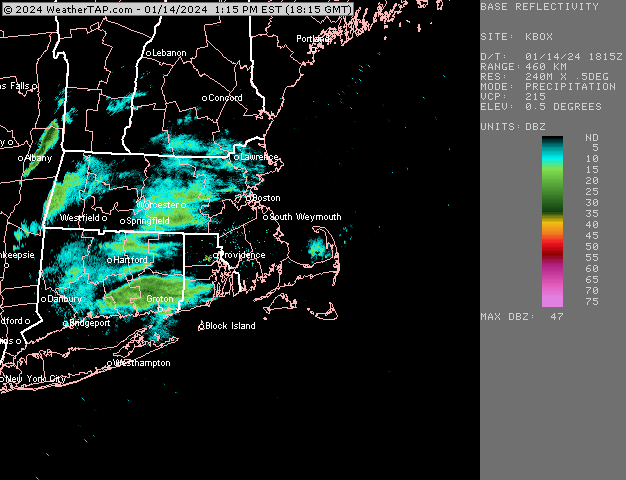
6 minutes ago, ORH_wxman said:
MAC011-015-141945-
/O.NEW.KBOX.SQ.W.0001.240114T1907Z-240114T1945Z/
Hampshire MA-Franklin MA-
207 PM EST Sun Jan 14 2024
The National Weather Service in Boston/Norton has issued a
* Snow Squall Warning for...
Northern Hampshire County in western Massachusetts...
Franklin County in western Massachusetts...
* Until 245 PM EST.
* At 207 PM EST, a dangerous snow squall was located along a line
extending from Monroe to near Pittsfield, moving east at 40 mph.
HAZARD...Intense bursts of heavy snow. Gusty winds leading to
blowing snow and rapidly falling visibility. Wind gusts
greater than 35 mph.
SOURCE...Radar and webcams.
IMPACT...Travel will become difficult and potentially dangerous
within minutes.
Locations impacted include...
Amherst, Northampton, Greenfield, Orange, Deerfield, Monroe,
Montague, Hadley, Sunderland, Hatfield, Northfield, Williamsburg,
Bernardston, Buckland, Conway, Shelburne, Leverett, Erving,
Shutesbury, and Ashfield.
PRECAUTIONARY/PREPAREDNESS ACTIONS...
Reduce speed and turn on headlights! During snow squalls, the
visibility may suddenly drop to near zero in whiteout conditions.
&&
LAT...LON 4238 7301 4239 7301 4263 7295 4266 7295
4267 7300 4270 7295 4270 7302 4274 7301
4272 7230 4238 7241 4234 7306 4238 7307
TIME...MOT...LOC 1907Z 252DEG 41KT 4273 7301 4250 7328
SNOW SQUALL...OBSERVED -
MRG getting crushed on web cam
-
1
-
-
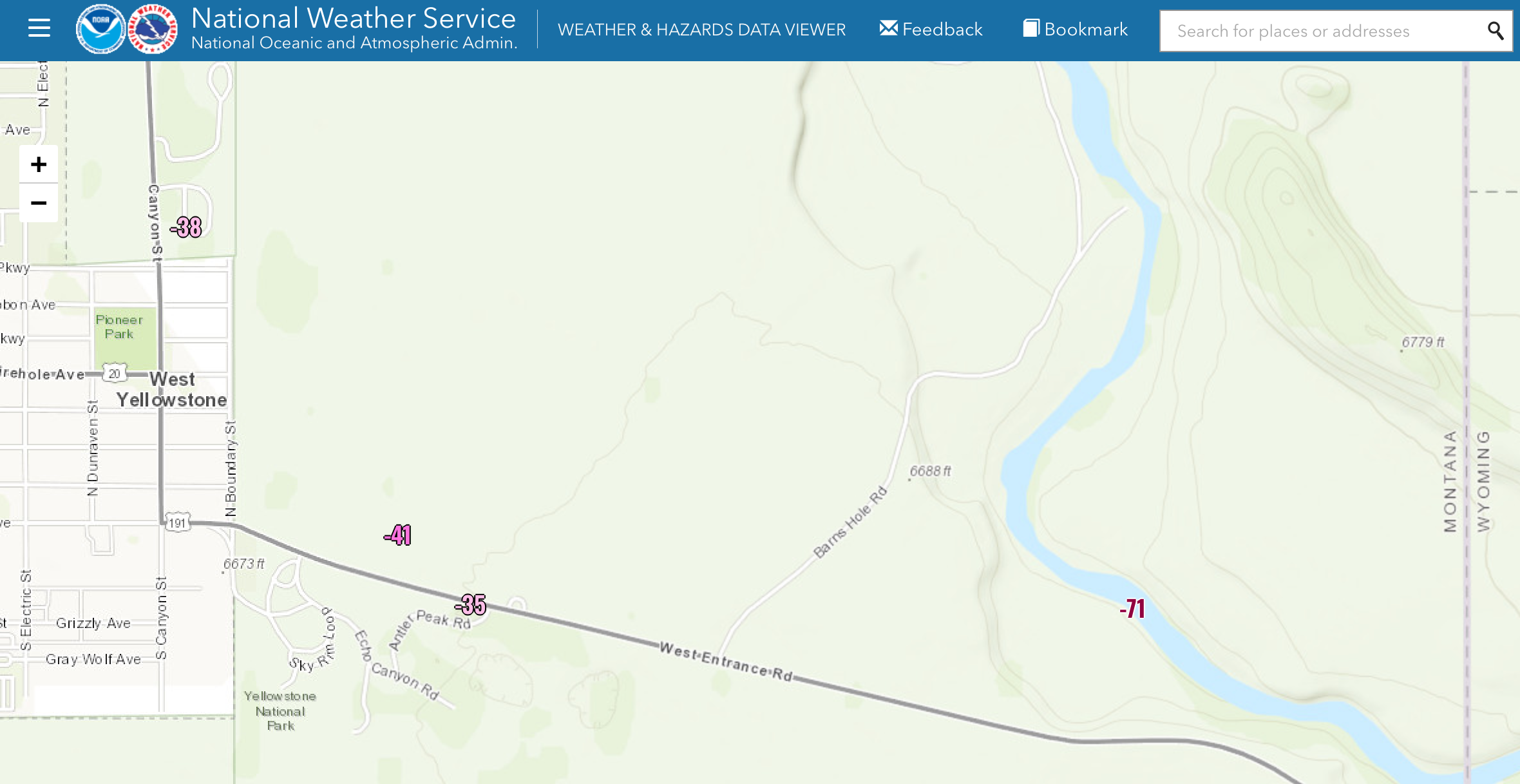
12 minutes ago, dendrite said:
There’s a madison river valley HADS site in West Yellowstone that reported -71° yesterday morning (MDSM8). Maybe it’s wrong, but it’s an interesting little bowl there. Maybe it radiates like the moon like Peter Sinks?

I believe that would be an all time record low for the CONUS if valid
-
1
-
-
you know what the worst thing about peacock? You can't project content with an HDMI port to an external display. It's mind boggling. And in my case, my Dell laptop running Ubuntu won't even let me play content locally, because the device itself has an HDMI port.
-
33 minutes ago, Patrick-02540 said:
It all comes down to the lost beer, hotdog, and merch sales. That's close to 2.5 million at a full stadium. The NFL calls Hochul and says, "Get out there and cancel the game. Blame it on whatever you need to, but keep us out of it."
Not sure if this is tongue in cheek, but I kind of doubt that played in. This is Buffalo after all. There would be zero lost beer and hotdog sales.
-
1
-
-
literally not a week since jackpotting a big storm-- must be something in the water
-
 2
2
-
-
sun has popped out several times, and within minutes it's cloudy and we're raining again. Little tiny convective showers with fat droplets.
-
1 minute ago, FXWX said:
Like most major decisions, it was made in conjunction with NWS folks and emergency management leaders... It really is not even about the game perse; it's about the safety of having thousands of travelers on the road and no way to get to them... Folks have short memories about how many people died last year in the Buf blizzard. I'd love to see a game in blizzard conditions, but it's the big picture more than the game....
I'm not editorializing on the decision, but I've seen a bunch of unhappy folks ripping the NFL when they're just doing what they're told in this instance. Not that the NFL needs me to defend em.
-
6 minutes ago, moneypitmike said:
So the National Fairy League postponed the Bills until Monday due to weather.
Kathy Hochul made the call fwiw
-
12 minutes ago, ORH_wxman said:
Some other notable WINDEX events I remember:
Feb 10, 2008
Feb 2, 2001
Mar 3, 1996
Nov 23, 1994
Dec 1, 2003
We had a good one in I think Feb 1989…awful winter but good squall that dumped a quick inch can’t remember exact date though.
The 1/28/10 event though was by far the largest for me since it dumped a quick 4”…the 1-2” events happen every now and then but 4” is rare outside of the mountain-enhanced terrain spots.
great stuff as always
this was our most recent one that I can recall... disco picks up for the fropa on page 18
-
1
-
-
34 minutes ago, dendrite said:
DFW has been below 10° once since 1996.As an aside, the low of 2 they put up on 2/16/2021 in today's global climate, and with the massive local growth that's occurred and associated UHI impacts, has to be the most anomalous number in their entire climo record. Next lowest going forward on the calendar is 10.
-
1
-
January 2024 -- Discussion
in New England
Posted
Heavy damp virga here
Meanwhile, euro ticking colder for next week. HP exits slower.