

radarman
-
Posts
13,187 -
Joined
-
Last visited
Content Type
Profiles
Blogs
Forums
American Weather
Media Demo
Store
Gallery
Posts posted by radarman
-
-
7 minutes ago, Angus said:
Wow, that is an impressive picture. I think I've seen that once before long ago. 1969 I presume. Jay Peak is the only major NE ski area I've never skied. I have a hard time justifying the drive given I'm primarily a day skier. Of course, I'm planning on leaving my house Friday morning at 4AM to ski Sugarloaf!
Actually that's a 'vintage'
 pic I took in April 2001. Courtesy of a disposable camera, sun bleaching, and a blown out scanner.
-
-
51 minutes ago, Jason215 said:
So Jealous of everyone who got out there!! What mountain did you go to? At this point, I feel like going to the tanning salon with my goggles on!
Local hill, Berkshire East. Softened around noon, skied beautifully thereafter.
-
 2
2
-
-
Perfect weather for the season end festivities in a lot of places today. Took in some of the cardboard sled races in between soft turns and they didn't disappoint. Burgers cooking on the summit for ski patrol fundraisers. Music and rays. Great day to be alive.
-
1
-
-
47 minutes ago, J.Spin said:
Some pictures from the day:
Nice ones as always. Here are few going up/down...
Inverness area is always pretty with open Birch forest. Much less windblown through here too. They should have spun the lift.


Once at the top, the choice of sticking in the trees was obvious as you were saying. Lighter and somewhat less windblown.

Exposed trails didn't hold that much snow in the face of the battering, but protected trails did. But the mounds were whipped into big, slabby crests that were tough to navigate. Could have used about 130s underfoot and just gone straight.


-
1
-
-
13 hours ago, Hitman said:
Sb reporting 23”. Most lifts at Lincoln on windhold. Mt Ellen looking good.
Ellen never spun chairs other than the park quad. Skinned up to the summit, super windblown, very dense. Deep in the woods. Tough traveling at times.

-
2
-
-
8 hours ago, BrandonC_TX said:
There was a 75 mph wind gust reported at Fort Worth NAS JRB per the storm reports on SPC's website. I'm close to that area and didn't get any sort of strong wind gusts at my location to my understanding.
EDIT: updated severe thunderstorm warning for Dallas County mentioning 80 mph wind gusts as a possibility. Hearing reports of power outages in various areas of DFW over Facebook. Expecting to hear reports of storm damage filter in across the DFW area over the next few hours especially once daylight comes along.Substantial damage... Grand Prairie airport took it on the chin with many planes destroyed and a report from an anemometer (off the ground) at 95kts. An Amazon building near DFW airport lost a roof with video on twitter. A large tower folded up in Godley in what might have been a QLCS spin up. DFW ASOS measured 78MPH, 71 at Addison airport. Etc. etc. Best line since 3/29/17
-
1
-
 1
1
-
-
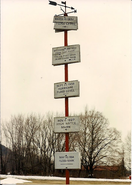
15 minutes ago, HIPPYVALLEY said:
There was devastation across all of New England. The high water marker on the Millers River along RT 2 in Erving is 6' over the highway. Bratleboro, Turners Falls, Holyoke, Hartford were all devastated.
Deep snow pack with high water content and a screaming Sou'Easter sending water down ice jammed rivers gets it done. If that happened this year we have the water content in the pack but maybe not as much ice to damn the rivers, at least down here.
Even Keene had severe flooding. All along the river was very bad, this road sign in S Hadley tells the story.
-
5
-
1
-
-
Berkshire East was outstanding this morning, probably the day of the year so far. 6" new cakeflour, powder was the theme, but some of the finest cord imaginable deserves a shout out too.
.thumb.jpg.901c6ec7d0a667cfeb112cc4589cfcad.jpg)
-
3
-
-
Hit 52 on the UMass wx station, maybe a top 2 or 3 event. I want to say a similar Feb 2013 overnight fropa rivalled it here. Limbs down all over the valley, partial collapse of a mill in Holyoke, and no power here locally for the past two hours or so.
-
1
-
-
Snowed most of the day at MRG, heavy early and again later in the afternoon. I'd call it a foot fresh, skied well.
-
5 minutes ago, HoarfrostHubb said:
I always forget the month for that. It was in December by my memory, but January makes sense now... That one was awesome
while we're tossing around
 analogs, I kind of enjoyed the 2/2/18 like enhancement up the Pelham hills to YBY that the 3km nammy was advertising
-
hopefully a 1/28/10 redux, one of our faves
-
Felt good for Magic yesterday. Full house on a holiday weekend powder day. We waited in line but still had a great day. Hope they raked it in.
-
2
-
-
Speaking of Berkshire East they made a ton of snow in early Dec and the soft turns and mild weather on Saturday afternoon were really enjoyable. Steeper trails were in excellent shape. Gotta feel for them though given the utter lack of natural and the unfavorable forecast.
-
1
-
-
41 minutes ago, Hitman said:
I think the carpet allows the lift to run at a faster speed than otherwise.
Yes. The carpet at Berkshire East (which I dislike) allows for a relatively quick moving fixed grip quad. I don't see the point of a carpet for a detachable lift that's hardly moving at loading time.
-
Mt Snow is 29 bucks tomorrow online, should be a real nice day no matter where you end up.
-
2 hours ago, alex said:
Greetings from Tahoe! Not a ton of snow but it's like fantastic spring skiing in December
")

Is that Homewood?
-
One foot after the other on the way up, but it pays off.


.jpg)

-
1
-
1
-
-
Magic was off the charts great today.

-
1
-
-
On 11/22/2018 at 8:25 AM, PowderBeard said:
The 8-10" Magic got up high on Tuesday skied pretty well. They have so much snow they are opening Saturday with 30+ trails.
Yeah it was awesome today. Goniff in November?


-
2
-
-
3 minutes ago, Hoth said:
Just had to throw that map in my face didn't you. 2.7" while 20 miles away put up 20".
That's actually the wrong link I put up... that wasn't really an elevation event last March. That event had huge gradients, but a torched BL wasn't the issue as it was in March 2013.
-
47 minutes ago, Ginx snewx said:
I got in a big argument with HM back when he was a punk kid lol. He said 250 ft more elevation couldn't possibly be any influence. Argument ended a week later with time stamped pics of a 4 inch wet snow difference. I still have the pics
March 2013 had a gradient like that here... maybe over the course of like 400', but still.
-
2 minutes ago, HIPPYVALLEY said:
You had school today? Everybody out here cancelled.
Not even a delay at UMass.


.jpg.c1563c4dc2363de41b0643ccae4df31a.jpg)

April Discussion
in New England
Posted
Really was a spectacular morning...