

radarman
-
Posts
13,203 -
Joined
-
Last visited
Content Type
Profiles
Blogs
Forums
American Weather
Media Demo
Store
Gallery
Posts posted by radarman
-
-
Very solid storm through here. Lightning, rain blowing sideways, winds shifting.
-
 1
1
-
-
Just now, HIPPYVALLEY said:
Welp, weak sauce. Got 5 minutes of torrential rain.
I think the worst of it stayed to your west, through Ashfield, Conway, and Goshen. Observing low end severe winds on radar at 2500' , and evidence of updrafts in the line that could be producing peas or something. Weakening a bit as it drops S.
Thunder in Btown.
-
1
-
-
13 minutes ago, weatherwiz said:
I forgot where i saw this but I saw something that smoke from Mexico may have advected into the region which yielded the H7 cap and temp rises which were not modeled.
Well it certainly was a beastly cap on the FWD special sounding. Wasn't so obvious at OUN, but it's possible the smoke was still driving north up I35 when the balloon went up.
Anecdotally, I've seen quite a few lines/linear segments approach the DFW metroplex this year with the primary tornado risk being with any cells that popped out ahead, but remarkably little has popped. And this is even with the backdrop of a ton of surface moisture for whatever that's worth. Certainly no lack of overall convection, but the cap has seemed to hold until the main forcing has arrived.
-
Just now, Typhoon Tip said:
I'm kinda of curious ...
two days ago there was a lot of mainstream media headlining about the 'catastrophic' tornado outlook ...
yesterday ... I didn't notice as much drama from those same sources, and even SPC didn't appear to elevated; yet, just taking a quick look at their storms reports graphic spanning the last three days, it almost seems yesterday was comparable to in tornado results to the day of the supposed catastrophic outbreak.
Not attempting to impugn any one or agencies efforts ...but I wonder, if one day "looked" to be one thing and the other day turned out to actually do it, if that is a good opportunity to compare and contrast to identify why -
The forcing was more in question yesterday. Shear and instability were present, it was just a matter of initiation. Mesomodels started hinting that cells would form only about 18-24 hrs in advance. The high risk day they knew they'd have a lot of action, although the open warm sector may have underproduced compared with what was being advertised in the morning especially by the HRRR.
-
3 minutes ago, weatherwiz said:
They did an 18z balloon launch out of DFW (and I am guessing OKC) but I don't seem them anywhere
The DFW launch had a strong cap in place. Tremendous instability but seems somewhat unlikely it breaks.
OUN launch had slightly better winds, no real cap. Not quite as much instability yet.
-
7 minutes ago, HIPPYVALLEY said:
Raining here ATM
Same down here with what looks like more to follow. I suppose it could put off a weak rain cooled boundary that might yield some differential heating pike south later, barring more crap development in the meantime.
-
After 3 straight years of caterpillar destruction and several large, dead trees on the property have not seen a single creepy crawly bastard yet this year.
-
 1
1
-
-
On 5/17/2019 at 6:43 PM, dendrite said:

Had the yellow female first which made me stare out the window for 20 mins waiting for a male.
Such beautiful birds. These were the ones I mentioned last week.

-
13 hours ago, J.Spin said:
That three feel of accumulation wasn’t at valley level, it was well up in elevation. I don’t recall hearing much about damage during that event, certainly around here in VT. On Mt. Mansfield the snow line was around 2,100’ when I was there. Here’s the accumulation profile with respect to elevation that I found:
1,600’: 0”
1,800’: Trace
2,100’: 1”
2,200’: 2”
2,500’: 4”
2,600’: 5”
3,000’: 8”
3,300’: 10” – 12”-15”
It’s possible that they had some tree issues over in the Adirondacks, but above 2,500’ or so, and certainly above 3,000’, the accumulations are almost irrelevant with respect to the trees – at any time of year. The trees are essentially all evergreens that are built to take on any sort of snowfall at any time of year without issues.
Yeah, there was about 3.5" at the bottom of Superstar, 8-12" at the top of the chair, and a hike up to the summit had me knee deep in spots. Unforgettable day for sure.


-
9 minutes ago, dendrite said:
Love them. The only ones I may love more are indigo buntings.
Lots of activity this morning...orioles, rose breasted grosbeaks, hummers, catbirds, finches, etc. The only elusive feeder bird for me has been bluebirds.
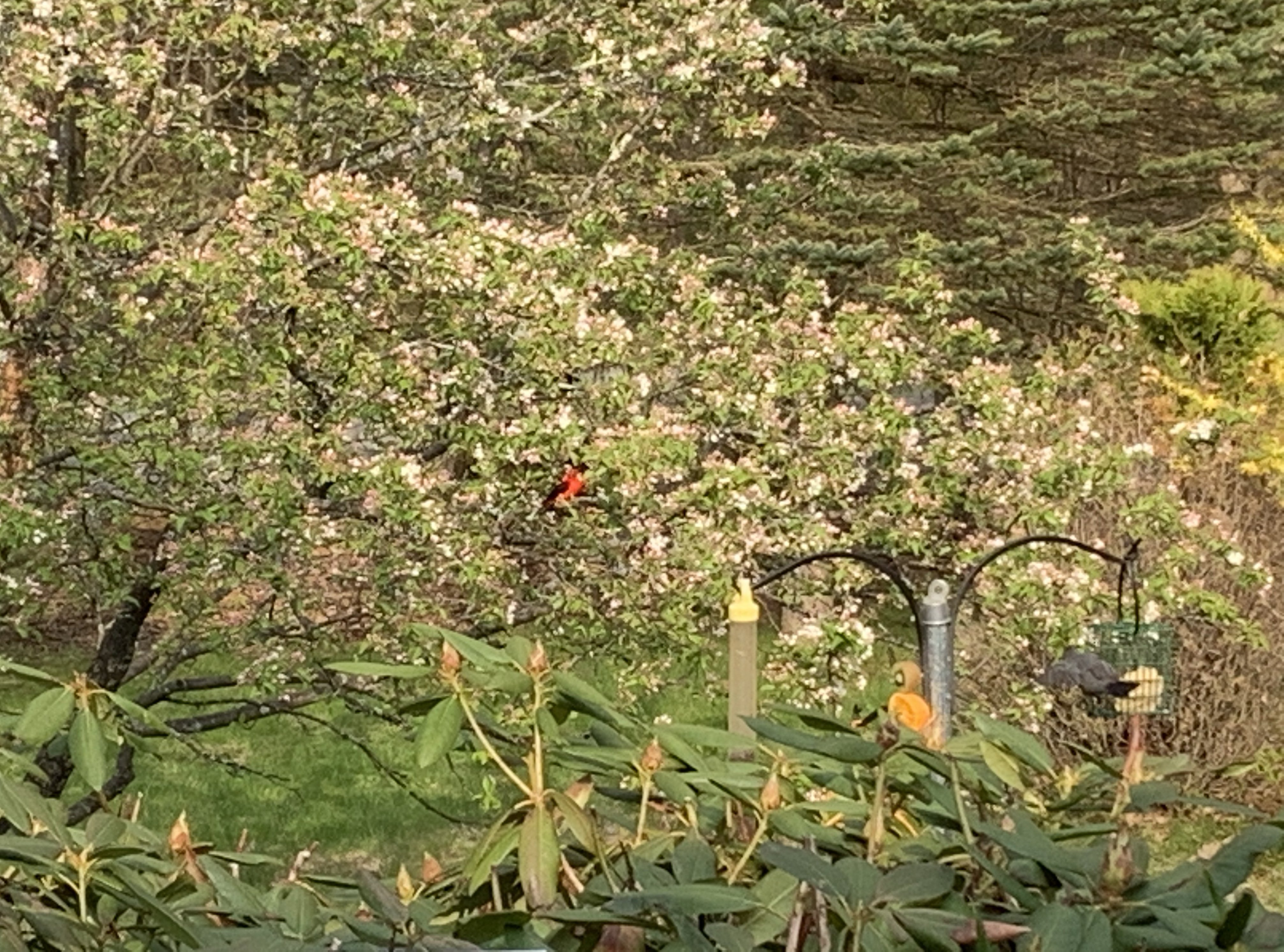
We have seen a few bluebirds this year. Lots of cardinals, phoebes, wrens, robins, goldfinches, red bellied and pileated woodpeckers, and our ruby throated hummingbird friend that always appears shortly before the late blooming red azalea pops. The tanagers were a first that I can recall.
-
2 scarlet tanagers in the yard. Brilliantly colored!
-
1
-
-
End of the week outdoor commencement ceremonies should probably start taking note of that incoming trough. Euro suite lost the surface reflection and keeps the surface low west of us.
-
This was the Denton tornado from Tuesday evening (may need to click to animate)

-
1
-
-
Just a beastly little cell yesterday, overachiever for sure.
KBOX on the left

-
6 minutes ago, CT Rain said:
How high above ground is the beam in Willington?
A little over 6k' at the center of the beam. Northern portions of Tolland and Willington are basically the edge of the range. But it's actually 20km further than the old radar here from 2005-2013. We can see BDL now which is great, albeit further away than we'd like.
-
9 minutes ago, HoarfrostHubb said:
Brimfield, MA as per BOX

Wow
-
Wet hail in the cc data earlier

-
1
-
-
5 minutes ago, CoastalWx said:
Is really aloft and it’s likely too cool for anything other than a meso aloft. OCMs going wild at BOS area stations.
Part of the apparent weakening trend I mentioned was just the beam sampling it somewhat closer to the ground. Higher tilts still do depict a (weaker) circulation as you note.
-
1
-
-
Couplet has weakened a lot the last few minutes. Maxed out just before the border
-
8 minutes ago, Damage In Tolland said:
We TOR in Napril!
edge of our range but yeah not a bad couplet aloft, especially had we been plotting SRV. This is base:

-
40.5"
-
11 minutes ago, WxWatcher007 said:
Just had a 5.33"/hr rainfall rate as that line moved through.
Yeah it ripped through here too... Breezy, with a nice lil feature over Northampton


-
4
-
-
Something about Devil's Fiddle in the spring... The outcroppings have long since melted off, but the big swoop turns on the untouched soft snow were simply divine. Boot pack laps on the top yesterday with a path down requiring only short forays into the woods.


-
2
-
-
Killington is skiing really good today, and I expect tomorrow should be excellent as well. A lot of snow left, woods are in peak Spring form.

Spring 2019 New England Banter and Disco
in New England
Posted
Fresh jjjjjjulius and doubleganger though, 3 can limit