

poolz1
-
Posts
2,614 -
Joined
-
Last visited
Content Type
Profiles
Blogs
Forums
American Weather
Media Demo
Store
Gallery
Posts posted by poolz1
-
-
Just now, Chris78 said:
Only 22" for me. Fringed.

Hey, plenty of time to pull this north!
winds gusting 40+ at DCA. A true blizzard verbatim...
-
 1
1
-
-
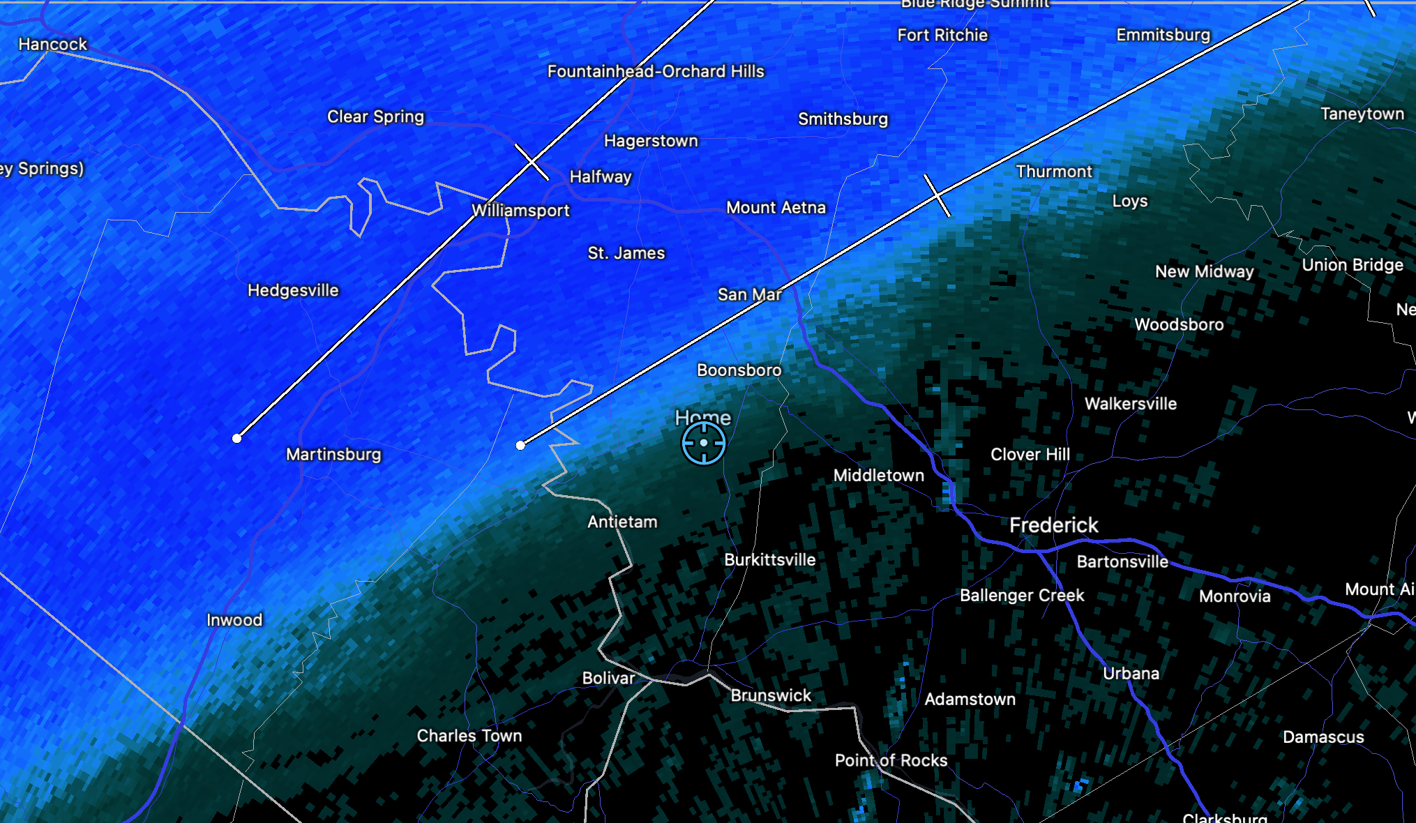
Mid afternoon death band raging.....temps upper teens.

-
 2
2
-
-
21 minutes ago, jayyy said:
6” IMBY in Union bridge
5” - my brothers house in Ellicott city
6.5” - my parents house in Rockland NY
8” - my brothers house in Rye NY
12”- my buddy in Dorchester MA
Rather large area of 5-12” from VA to MA. Successful storm, no doubt.
Hey...I have family in Rye NH! Small place but beautiful New England beach town. Been visiting my cousins there around July 4th every year since I was a kid.
ETA: Never mind! I see its NY you have family. lol
-
2 minutes ago, WxUSAF said:
Thanks for this... 6.6" reported about 3 miles to my N.....makes me feel better about my 6.2 measurement here.
-
1
-
-
6.2" on the ground .41" liquid. 22/15 with a gusty NW wind.
Definitely exceeded my expectations. .41" liquid is on the very high side of any model run for mby.
-
3
-
-
4.5" and currently lake effect style dendrites. I can see the back edge of the best dynamics approaching but currently it is a fog outside.
-
5
-
-
2 minutes ago, WVclimo said:
Maximum fluff factor with this one. With no wind, have had some really large agglomerates here for most of the event.
Even so, pretty sure I’ll end up with more liquid than any model’s forecasted QPF.
Good point. I wonder if models factor wind into their Kutchera outputs?
-
3 minutes ago, WVclimo said:
Interested to see that myself. Have two 4” gauges in different spots in the yard. I’ll post the LE when it ends.
Agreed. I honestly was scratching my head on my latest measurement. 1.25" in 45 min. Don't get me wrong, it is coming down nicely but I have seen heavier snow.
-
9 minutes ago, losetoa6 said:
Nice ! Probably 1" /hour here currently best guess
Flake size definitely has changed outside of that band. But, like most storms in their height, the radar doesn't do it justice. Just ripping smaller flakes now. Probably the heaviest snow of the event right now.
-
5
-
-
Absolutely pouring snow now....A classic banding with subsidence in between currently in the NW zones.
-
4
-
-
1.2 on the snow board. Surprised honestly....it is snowing at a good clip but not crazy. Must be some good ratios occurring.
-
2
-
-
2 minutes ago, Chris78 said:
Snowing moderately again.
3.5" so far
Dude, that's awesome! 3.5 already!
Mod/hvy here now in this band. finally some real snow....been jonesing a while for this.
-
1
-
-
Nice puff balls falling at a light/mod clip. .5" so far. Lets get this cranking!
-
1
-
-
Living on the edge....still light snow even though the radar looks meh right over mby. Enough for a coating so far.

-
16 minutes ago, Chris78 said:
Already have a car topper here in Smithsburg. Wasn't expecting it to start for a few more hours
You look to be in a good spot man. I am on the southern end of this "band" and its a nice, steady light snow but beautiful fluffy dendrites falling now as thing the dry air fades. Not quite a car topper here but getting there.
-
2
-
-
10 minutes ago, clskinsfan said:
I feel ya. I had flurries and now snow has stopped. This winter sucks.
")
Looks like that initial slug was just a blip...still light snow here but its pulling north. Once the stuff down near Luray gets up here it should be game on. Not too much longer.
-
1
-
-
Had about an hour of flurries being right on the edge of the precip. Light snow finally! 34/27
-
3
-
-
Little bit of a chilly airmass there at the end of the GFS run. Obviously, the end of an op run but with the projected pattern something extreme is on the table imo.

-
3
-
 1
1
-
2
-
-
This thing is booking it...no surprise there but western areas may see first flakes before the sun sets. Weenie radar with returns reaching out for SW WV already.
-
Looks like a busy period ahead. Most likely 3 events in 7 days for the MA. Ops have plenty of chances throughout the next two weeks. I do see the dryish look on the ens but wonder how much of that is due to a cluster of members having the entire tpv dropping down for an extended period and crushing everything....skewing things drier on the mean?
-
2
-
-
12 minutes ago, Bob Chill said:
Anecdotal evidence but strongly agree and have thought the same thing for at least 8-10 years. Hot hands rotate. We see it every winter. Gfs does ok in the mid range with northern stream shortwaves. Often the first model to pick up on one with potential. Euro does a nice job with pure southern stream waves in the mid range most of the time. Other than that, it's best to keep an open mind and apply your yard climo and what usually happens with a similar setup. Personally, I stick to the euro/gfs combo and just blend them with my yard climo. Works well for mid range thoughts.
Thing is, we're focusing on an acre of land with a model that covers every acre on the planet. What we often think are huge shifts really aren't. Some are absolutely miniscule but the sensible effect is huge. This often results in unfair criticism but that's a whole nuther barrel of worms.
Funny...I often think about this during the warm season. What if this was snow? Models calling for .5-.75" and we end up with .25" Nobody cares when its 65 and rain...hardly even mentioned or noticed. In Jan ending up with 1-2" when the forecast was 4-8" would create epic meltdowns. As winter approaches we all get out our magnifying glasses and browbeat any model not within .2" of verification.
-
4
-
-
8 minutes ago, Westendsnowguy said:
Maybe instead of just making posts about the GFS being the new king you can use some actual data.....oh wait, no you can't
")
Honestly curious, what data do you have to support anything different? Not doubt that the verification scores still suggest the euro is king. But these scores, at least the ones I have seen, only score NH H5. Each season, any global can have its own reign at the top when it comes to discrete systems. I have seen no scores when it comes to LP systems in our tiny corner of the NH....60 hours out. But, I would certainly take a correction from someone more knowledgeable than myself....and that aint hard to find!
-
1 minute ago, WinterWxLuvr said:
It’s so hard to tell with those maps. I think I’m the end result may be a littler wetter and faster.
And it’s the NAM
Less separation, stronger lead wave....Bad. BUT the lead wave over the NE gets outta the way and has less trailing energy to continue suppressing. Like you said tho....NAM
-
41 minutes ago, nj2va said:
18z Euro looks good for a region-wide moderate event. Generally 4-6”+ DC/north. 2-4” EZF/SE MD. 7-9” mountains.
Lets just lock that up right now please... A classic region wide light/mod event. All snow for just about everyone. Living vicariously through traffic cams sucks.
-
8
-
January Medium/Long Range Discussion
in Mid Atlantic
Posted
Was just going to post....Went from a south ATL low north of the Bahamas to a coastal NE snowstorm. Just a wag, but there will likely be some slight adjustment in the coming days.
18z GFS was close to a repeat of the 12z run for late in the period. Too much squish this run but the phase tried!
12z eps had a few nice signals. Including a beaut for the 12z gfs' timeframe...