

poolz1
-
Posts
2,614 -
Joined
-
Last visited
Content Type
Profiles
Blogs
Forums
American Weather
Media Demo
Store
Gallery
Posts posted by poolz1
-
-
06 GEFS mad a sig move toward a euro type solution. Long duration, tucked low. 4.5/5 days from when the low starts to reform somewhere in the SE. Cautiously optimistic that we are starting to see some general agreement. Obviously, the convoluted progression remains a red flag but can't deny the developments over the past 24 hours.
-
 6
6
-
-
I haven't looked this morning yet but I was bored yesterday and looked into the the few 12z EPS members that created a MA mauler late next week. Every single one had a much weaker ULL especially as it started to to feel the block and dive SE. 06z gfs is a good representation of this.
06z gfs with 3 snow events and what looks like a good one setting up for xmas day. Snow on snow xmas day? Come on! EJ would lose his mind...

-
2
-
-
4 minutes ago, Maestrobjwa said:
What I gather from this (and what I've seen the last few years) is...that the TPV does is difficult to predict in general, isn't it?
I really don't know to be honest. I would have thought that modeling would have at least been in the ballpark with this particular TPV. It was certainly a large feature in the NH and usually those are handle fairly well in the LR. But, maybe someone can correct me. To see that thing bounce like a rubber ball back to the west was a true Lucy yanking the football situation!
-
I don't know if saying the can is being kicked or things are "delayed" is correct? I mean, losing the TPV rolling under the block to SE Can and becoming a stable 50/50 feature forced the whole pattern to take on a different look. That TPV was the original catalyst for cold mid and low level flow and would be in place right now. We are now required to manufacture our own beast of a 50/50 or wait for the PAC to cooperate. This is different from modeling being slow on the cold press and things are just taking their time evolving.
-
6
-
-
22 minutes ago, CAPE said:
I just took a quick look at the Pacific basin on the means, centered around the 20th of Dec. Indication of more precip(convection) in the Western Pac on the EPS and GEPS, with not much going on in that region on the GEFS. The N Pacific Jet configuration on the EPS and GEPS is notably more extended than on the GEFS to my eye. This explains at least in part the differences we are seeing in the advertised h5 patterns. The base state in a Nina is usually hostile to our goals, so it's always a fight. The other problem with the latest GEFS runs is the -NAO looks wonky and weaker, and if that is close to reality it won't do much to mitigate an unfavorable Pacific.
I know the RMM plots don't necessarily tell the whole picture but interesting that the GEFS pretty much went all in on the MJO reemerging into 1,2. Curious if todays runs start to shift to a colder outcome in the LR.
-
2 minutes ago, WxUSAF said:
I haven’t looked at any guidance this weekend besides charts that have been posted here, but I want to see the Pac pattern easing get to D8-9. Seems like based on what people have posted, we’re on the hairy edge of that? Hopefully it holds through Tuesday-Wednesday.
Still D10ish away on the eps. By D13 things really start looking nice.
But, I agree...A change in the PAC is still a figment of LR modeling imagination.
D13
-
The end of the EPS run again with an Aleutian low getting into a nice position. Impressive HB. Follows pretty well what the weeklies showed for week 3.
-
4
-
-
If anything, at least this gfs op run resembles what its ens have been spitting out.
-
5
-
-
Nice to see our threat windows becoming a bit more clear today. Ind ens members continue to get snowier as well. A steady march in the right direction today, imo.
-
1
-
-
21 minutes ago, WinterFire said:
Not to nitpick but aren’t 50-50 lows traditionally at…50N-50W? My geography may be off but I’m not sure how helpful a 60-60 low would be for us…
lol yeah, that's called a 50/50 hopes and dreams shredder!
-
5 minutes ago, Round Hill WX said:
Not sure what you alluding to. Doug was at NBC10 and was getting poached by CBS3 near the end of his contract. NBC10 attempted to renew him but negotiations failed. He went to CBS3 and NBC10 enforced the “no compete” clause which kept him from joining CBS3 for 6 months. That doesn’t happen if the “contract isn’t renewed.”
When his CBS3 contract expired he came home to WRC when Bob Ryan retired.Your mention of Bob Ryan made me a bit nostalgic . Anyone remember Gordon Barnes? Felt like he was a radio meteorologist in the 80's. Remember clearly listening to him forecast a storm 3 days in advance..."30% chance of snow" we ended up with 11" of powder. No knock on Gordon...just a sign of the times. Play it safe until its not safe. lol
-
4
-
-
Another image to clutter the thread it but shows an interesting feature off the west coast. Over the past 24 hours the GEFS have trended to make the trough east of HI the dominant trough in the PAC. Not strong enough to send a major PNA ridge up and force a cold/dry pattern but enough to entice some mild ridging in the rockies. Maybe this feature will be what spins off plenty pieces of energy to play with as the NAO matures/relaxes.

-
9
-
 2
2
-
-
BWI: 22.4
DCA: 17.1
IAD: 27.4
RIC: 10.6
SBY: 14.2
-
2
-
-
2 hours ago, frd said:
Only concern is patience. Going to take time for the trough to get established in the East, most likely by mid December. Colder air will be slow to move in from the NW. Snow before mid December seems confined to areas far North and Northwest.
What we really need is upstream ridging and improvements from the Pac. A - NAO, even this powerful, does not gaurantee a sizeable snowfall in the Northern Mid Atlantic this time of year. I would think by the third week of December things look more favorable for snow potential in our region.
How long a favorable snow pattern lasts, when and if we get one, is hard to tell. Certainly appears we will be in a period of - AO and - NAO, along with weak zonal winds during December. We also need to monitor the West based block in the weeks ahead to see how it evolves, as it will play a major role in cold air delivery and storm track.
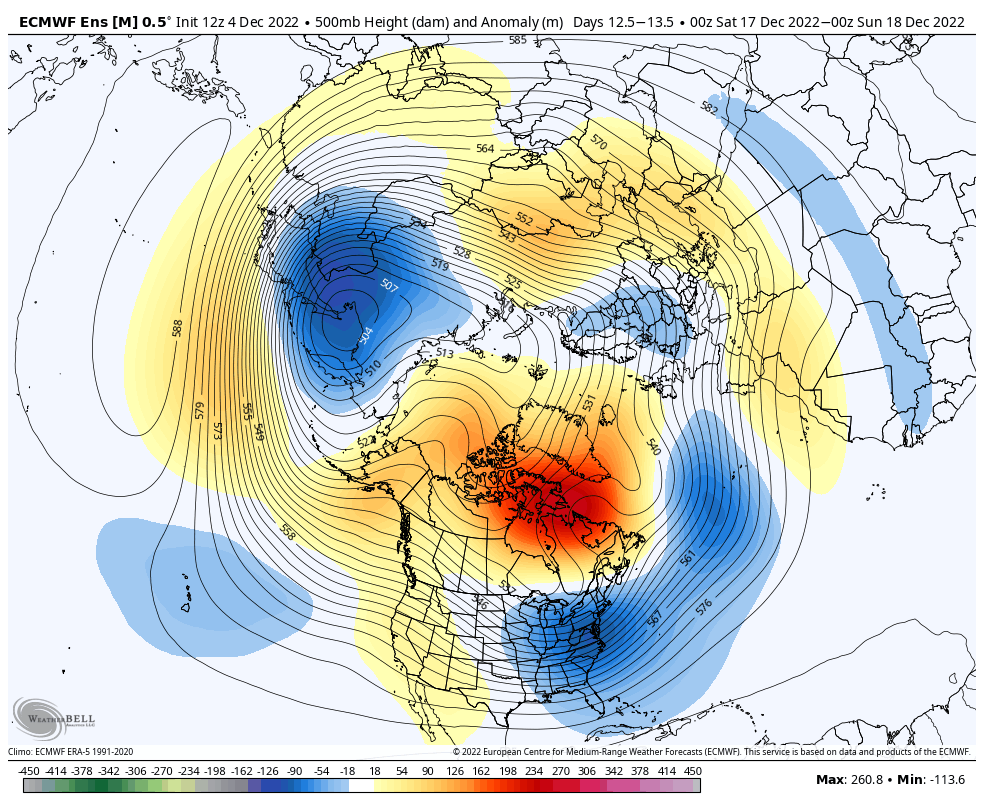
Good to hear from you man. Patience no doubt for the both of us but the coastal plain may have to be even more patient. I did like the 12z eps not just for the burnt orange in right spots but also the quicker release of the "handshake" between the Canadian TPV and the break-off ULL off Cali. Resulting in a more neutral PNA.
I get the pitfalls of parsing LR progs but the stout NAO seems like a pretty good bet. The ancillary pluses and minuses may dictate whether we need to break out snowblowers or just continue our Nina frustration. At least the beginning of this flick has grabbed our attention!
-
1
-
-
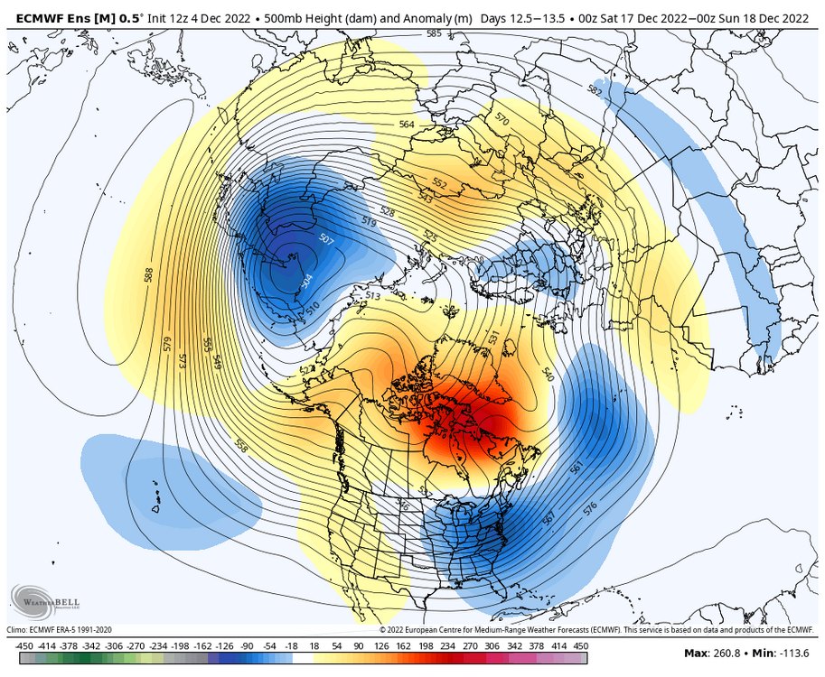
Not that we have had a shortage of beautiful looks but this EPS run was stellar. ^
Very end of the run shows a retrograding tough into the east coast with a stable and stout west based block.
-
1
-
-
It is pretty nice to see ens of all 3 globals with a robust block that appears stable. One constant moving forward is the supply of 50/50 lows. Even through the brief warm up coming we still see this feature.
-
6
-
-
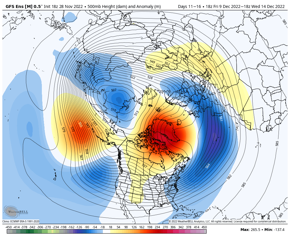
12z gefs with a workable PAC now late in the run. Pretty sizable shift toward CAPE's eps post earlier.
-
5
-
-
21. Coldest morning of the season
-
1
-
-
7 minutes ago, Ralph Wiggum said:
Many of us had a lengthy discussion last year and iirc by the end we were in agreement the PAC/Western Canada/Western US is probably more important than just a -NAO. The latter can certainly slow things down and keep systems from completely cutting but without a cold air source due to a crud PAC, a -NAO is 'usually' not going to do it alone. It has happened before and can do so especially as we enter 2nd half winter where those wavelengths between shortwaves shrink.
This was just figured out last year?
-
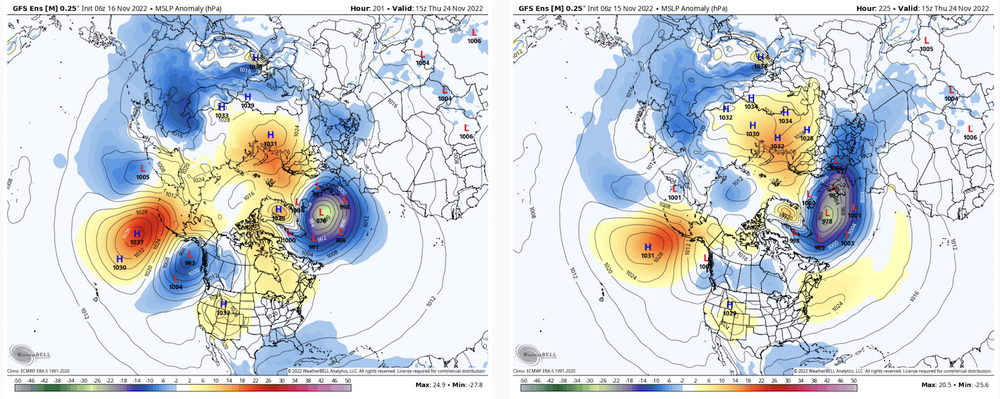
Regarding the Thanksgiving time storm potential. Yesterday's 12z run the GEFS started the idea of backing the trough off the west coast. Some those runs that nose a fresh cold high down in time may start to get some legs. Ens now showing surface high pressure in SE Can and New England compared to 24 hours ago.
-
8
-
-
It has been rain since the leading edge came through as snow. Changed to a mod sleet/rain mix now.
-
First flakes of the season! 35 degrees
-
4
-
-
Someone is going to thump tomorrow evening. Maybe closer in than previously modeled as things today have inched cooler.

-
4
-
-
1.8" total

December 2022 Medium-Long Range Disco
in Mid Atlantic
Posted
Who would have thought we would be looking at a PAC and Arctic that looks like this as we near the end of Dec? Appears pretty stable at the end of the runs as well. +QBO, -PDO, Nina