

poolz1
-
Posts
2,614 -
Joined
-
Last visited
Content Type
Profiles
Blogs
Forums
American Weather
Media Demo
Store
Gallery
Posts posted by poolz1
-
-
May be the first time I wake up early to track a cold front. Gonna be fun to watch even if no snow occurs.
2.08" so far and the creek has spilled into the yard. Sounds like a freight train outside. At least the dog won't be tracking mud in for the next few days.
-
 5
5
-
-
1 minute ago, WVclimo said:
I’m up to 1.20” of liquid for the event. Still 34° with plenty of snowpack left.
1.44" so far and the creek is almost out of its banks. Unfortunately, only about a half inch of slush left here.
-
Column must be continuing to cool some. Now light returns are remaining all snow. Solid coating so far but hoping to hold on for a few more hours as the next batch moves in.
-
3
-
-
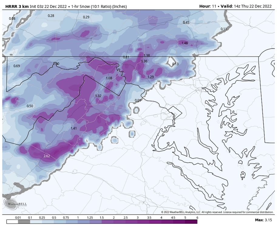
Latest HRRR with plenty of 1"/hr+ rates tomorrow morning as NWS noted in their latest AFD.
-
Quote
.SHORT TERM /THURSDAY THROUGH FRIDAY NIGHT/... Moisture will increase gradually through early Thursday morning. Wintry precipitation is expected to move from southwest to northeast early Thursday morning. Cold air is expected to be abundant across the area via cold air damming. Still expecting the Potomac Highlands and western MD mountains to start as snow. There remains uncertainty with when the transition to a wintry mix of sleet, freezing rain, and snow occurs. There is frontogenetical forcing increasing in the low to mid levels in most numerical guidance. Current thinking is dynamic cooling from heavy precip (QPF of 0.1-0.2" an hour) will allow for snow to be the predominant precipitation type in this area through the morning. The typical climo factors will be in play with an easterly flow favoring more of a sleet/freezing rain forecast for western Garrett County, MD given the subtle downsloping and warming while snow/sleet is favored to the east.-
1
-
-
4 minutes ago, Kevin Reilly said:
Media PA southeastern PA we have 28 degrees and dewpoint of 14 degrees but with a dreaded southeast wind at 2 mph so temps will hold steady and slowly rise soon.
That coastal low will do its job in turning the flow NE even for your area temporarily. Out here, surface flow doesn't turn S/SE until 06z or so Fri. Kind of a crazy little micro climate before the big arctic push.
-
1
-
-
5 minutes ago, Ephesians2 said:
31.3/9.9 in Fredericksburg. Several degrees colder than forecast. I'm under no illusions that I will get anything out of this, but might be a good sign for the western/northwestern half of this forum.
Think maybe that DP is off? Im at 20 up here...HGR is reporting a 19 degree DP.
Regardless...I do agree that temps are running a bit lower than forecasted. I am at 28 and the forecasted low is 29 here. I'll expect the typical few degree bump once clouds roll in.
-
1
-
 1
1
-
-
1 minute ago, clskinsfan said:
WWA up for the Winchester area if anyone besides me cares. 1-3 with 3-5 lollies. White Christmas chances looking better IMO.
URGENT - WINTER WEATHER MESSAGE
National Weather Service Baltimore MD/Washington DC
351 AM EST Wed Dec 21 2022

MDZ003-VAZ027>031-507-WVZ051>053-211700-
/O.NEW.KLWX.WW.Y.0035.221222T0900Z-221222T2100Z/
Washington-Shenandoah-Frederick VA-Page-Warren-Clarke-
Northern Virginia Blue Ridge-Morgan-Berkeley-Jefferson-
351 AM EST Wed Dec 21 2022

...WINTER WEATHER ADVISORY IN EFFECT FROM 4 AM TO 4 PM EST
THURSDAY...

* WHAT...Mixed precipitation expected. Total snow and sleet
  accumulations of 1 to 3 inches with localized amounts around 3
  to 5 inches possible, especially west of Interstate 81. Ice
  accumulations around a trace to a tenth of an inch with
  localized amounts around a tenth to a quarter inch along the
  Blue Ridge Mountains.

* WHERE...Portions of north central Maryland, northwest Virginia
  and panhandle West Virginia.
I care man! Ha! I do like the trend so far for temps to remain pretty much in the 30s west of the BR before the front moves through. Should be able to hold onto some snow cover if we can get a nice burst for a few hours. Typically, these things trend a bit colder and faster....as you know.
-
1
-
-
Not to beat a dead horse but those temp drops are insane. MBY - 45 at 7am, 14 at noon, single digits by 5pm with winds gusting 40+. Just need a roof blizzard to go along with it....
-
2
-
-
Cant deny the trend for more of the tpv being pealed off and creating some confluence. No indication that it makes a ton of difference so far, especially for eastern areas. But, if things keep trending for another 24hr it may create a scenario of more frozen.
GFS - CMC
-
2
-
-
4 minutes ago, psuhoffman said:
Feb 14 2014
Yes! '14. I remember being on the outside looking in with the majority of the ULL pass. Still put down around a foot imby but I think places east had close to 2'.
Would you consider the GFS/Euro to be a similar evolution to the feb 14 storm?
-
I have a terrible meteo memory but is this type of evolution similar to a storm we had in '15? I recall a distinct lull between the coastal and ULL. Great storm but disjointed iirc.
-
This won't be a 06z type run. Looking ripe...
-
1
-
-
5 minutes ago, frd said:
Things looking good moving into Jan. PV still under pressure even though it may temporarily get a little stronger. Scandi High and good support for a + PNA. Also looks active. Exciting possibilities next week and later in the month. EPS had some really deep members at this range for the 23 rd. Could be a rather intense cyclone along with very high winds.
As other have noted this morn...it really does look ripe for a major storm. I would love to start tracking something legit .
-
1
-
-
4 minutes ago, CAPE said:
It seems we may get a RELOAD after a slight relaxation. No signs of a 'close the blinds' period.
")
Would be pretty sweet considering the time of year and we would have a much better base state to start from. Nothing in the NH needs major work and isn't a terrible look as it is.
-
3
-
-
All 3 globals with a solid signal for scan ridging to return D12-15. With the MJO forecast to pretty much mirror its last rotation you have to wonder if we set this whole pattern progression up again early Jan.

-
7
-
-
7 minutes ago, WxUSAF said:
#CAPEStorm2022
Exactly....Eastern shore signal. I think CAPE should start his own forum for coastal areas and off shore oil rigs. LOL j/k
-
1
-
 4
4
-
-
1 minute ago, DarkSharkWX said:
The best conditions for optimal ice accretion are greater wind speeds(takes away hear from surfaces and advects cooler air), small droplets falling through a shallow melting layer, lower wetbulb temperatures, and lighter precipitation rates(heavier precipitation rates lead to more runoff and less efficient accretion).
Agreed but I have found that light wind is best. Too much wind and or heavier precip both help to encourage mixing of what is typically a very shallow subfreezing surface layer.
-
1
-
-
A lot is going to depend on cloud cover early in the eve/night. We are not coming out of a cold period where surfaces are already below freezing and temps seem to be in that 30-32 range during any icing. Unless things tick colder by 2-3 degrees I just don't see this being much of an issue outside of the far western valleys.
-
I think I can hear the Jaws theme....
-
1 minute ago, Scraff said:
Someone say WVU!?

Cheers my friend! Class of 2000...
 Showing my age! lol
-
1
-
-
1 hour ago, psuhoffman said:
I remember all the hits too, unfortunately that’s a much smaller list.
I’m lucky to have a good memory. Secret is I never studied and I’m not that smart…I just remember everything. I do think there is value in knowing how we’ve failed though.
Had a roommate at WVU who's memory was very similar. So frustrating seeing him party while I studied my butt off and he still scored higher that I did. It is def a gift.
-
^That west based block looking better on each ens run
-
6
-
-
Single digits and a fresh 4-8" carpet of white on xmas morn. Book it!
-
6
-

December 22-23, 2022: Warm Rain to Arctic Chill
in Mid Atlantic
Posted
That traffic cam out of Keysers Ridge looks pretty intense.
Hope travelers are prepared...this batch of rain moving through now increases the chance of flash freezing on the roadways.