

WxWatcher007
-
Posts
36,088 -
Joined
-
Last visited
Content Type
Profiles
Blogs
Forums
American Weather
Media Demo
Store
Gallery
Everything posted by WxWatcher007
-
I should have stayed at the g2g to watch this come in lol. Trend is our friend right now.
-
Looks excellent
-
I feel slightly more bullish this morning. Decent advisory event for much of CT I think.
-
Still going late Friday
-
In all seriousness, and forgetting the exotic op solutions, the gfs has been on an island. Even a blend of guidance would yield a nice warning level event for most. That’s a win.
-
Don’t kill the dopamine drip vibe. Let us valley weenies hallucinate.
-
Canada delivers. I’d sign right now for that.
-
-
12z 18z Ray is right. Nothing good comes with it going nuclear that far south.
-
-
As far out as it goes but this doesn’t look too bad to me with that cluster near the Delmarva.
-
It’s been meh from the jump but it’s mostly been on an island as you know. Would like to see it juice up tomorrow but this one seems pretty stable to me.
-
I’ll take an advisory but if we backed into a low end warning event that’d be awesome.
-
18z Euro looked nice here. And the clown map
-
Shades wide open. Never wavered.
-
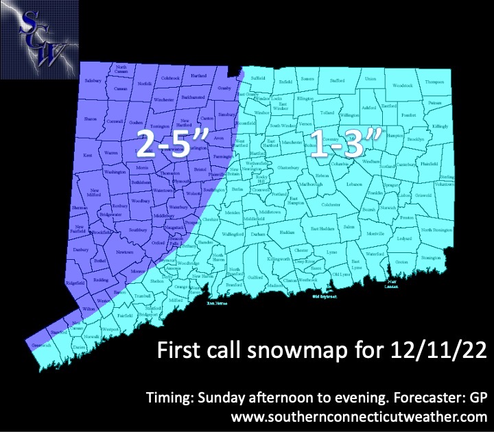
Hopefully that trend continues through game time though. We went with a general 1-3 for central and eastern CT and 2-5 for western spots. Caveats—more away from the coast, SW and central CT may see more depending on banding. Expecting some tweaks tomorrow. I think there’s upside to this one.
-
Ray must love this thread
-
As long as East Hartford gets in on it too
-
Yep, first good measurable is always fun. My one advisory and one warning level bar might be cleared by this time next week lol.
-
-
Shouldn’t we get a separate thread now for Sun-Mon?
-
Banter, but I don’t remember this one. Hurricane force wind gusts??
-
Do you think we run the risk of this developing too far S or redeveloping too early?
-
I cannot imagine what a broken weenie spirit would look like for him. Just picture the melt.
-
This place is too much


