

WxWatcher007
-
Posts
36,088 -
Joined
-
Last visited
Content Type
Profiles
Blogs
Forums
American Weather
Media Demo
Store
Gallery
Everything posted by WxWatcher007
-
25.5/23 -SN 3.1” measured
-
Great stuff in this tread today.
-
29.2/26 -SN/SN 1.4” on the board at 5:10.
-
Just dropped below freezing and started coating immediately.
-
Is this a paid radar? I think we’re in good shape. As Will said, not really expected to get good until tonight.
-

New England Met Winter 2022-2023 Banter
WxWatcher007 replied to HoarfrostHubb's topic in New England
Mower died as I was trying to get a needed final cut imby. Going to need to get something more powerful next year. -
High of 34.1 Currently 33.0/27, -SN
-
Although it's lower confidence than I'd like, I feel pretty good. Like I said earlier, most get 3-5 inland but someone will get smoked if that banding materializes. Hopefully over my head.
-
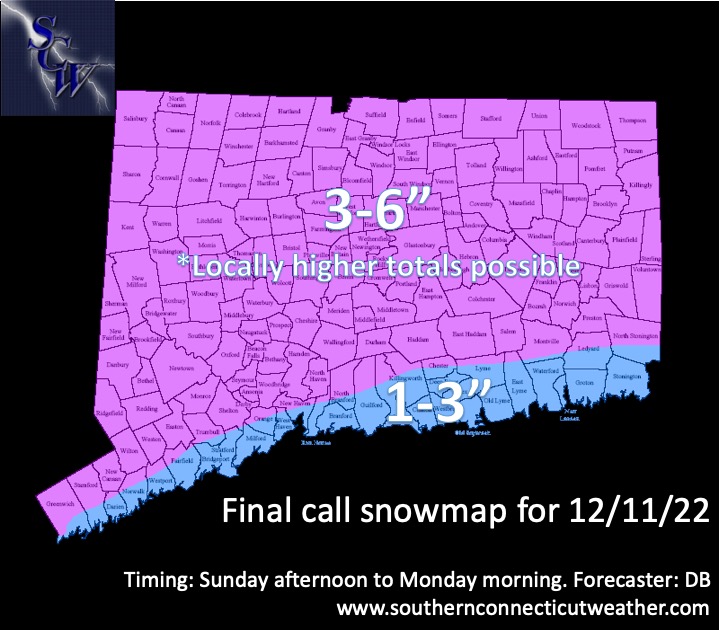
I've been writing my final call but my map is a compromise between high res and globals. 3-6 inland with locally higher possible, 1-3 at shore and part of SE CT. Most are between 3-5" inland but we watch for an overperformer in a narrow zone in the state. Where? Most likely northern CT but could be north or south.
-
32.4/25
-
NAM is really nice once again for CT, keeps bouncing the jack around but the signal is definitely there. I think I'd trust the high res more in this instance given the dynamic nature of this one but there may be some serious winners and losers if you're on the right/wrong side of a heavy band.
-
Can it get more juiced than it was already? lol
-
I love that this is a potential overperformer, but man I hate trying to forecast it. Agree about the Sunday timing. I think I'm going to hold with my 2-5/1-3 call but part of me wants to go big(ger) with 1-3 coast/2-4 mostly inland/4-8 in a *narrow* stripe in N CT. I'm not sure there's enough confidence in that though.
-
This looks fun
-
Tells me everything I need to know
-
AEMATT?
-
Good point. We still have time and it’s probably most helpful to see the full run. It’s likely to be chaotic for a few more days.
-
That’d be the hope. Still plenty of time for movement in either direction.
-
NAM continues to look robust here in CT
-
Back to…wx? Looks like more inland lows at 18z 12z EPS 18z EPS
-
Thinking 1-3" along the shore and SE CT with a broad 2-5" inland with locally higher amounts. Looks like a nice light to moderate event with some upside if everything goes right and those beautiful soundings verify.
-
Raises hand
-
Warning level would be fantastic but I’m not banking on it. Obviously.
-
I can't believe the accordion came out
-
Had an awesome time.

