WxWatcher007
-
Posts
35,726 -
Joined
-
Last visited
Content Type
Profiles
Blogs
Forums
American Weather
Media Demo
Store
Gallery
Everything posted by WxWatcher007
-
Absolutely. I’ll roll the dice on a pig ridge.
-
Speaking of the pattern, it’s intriguing. Give me a strong enough ridge to get this to the central, or better, northwest Bahamas, and I’ll take my chances with troughing.
-
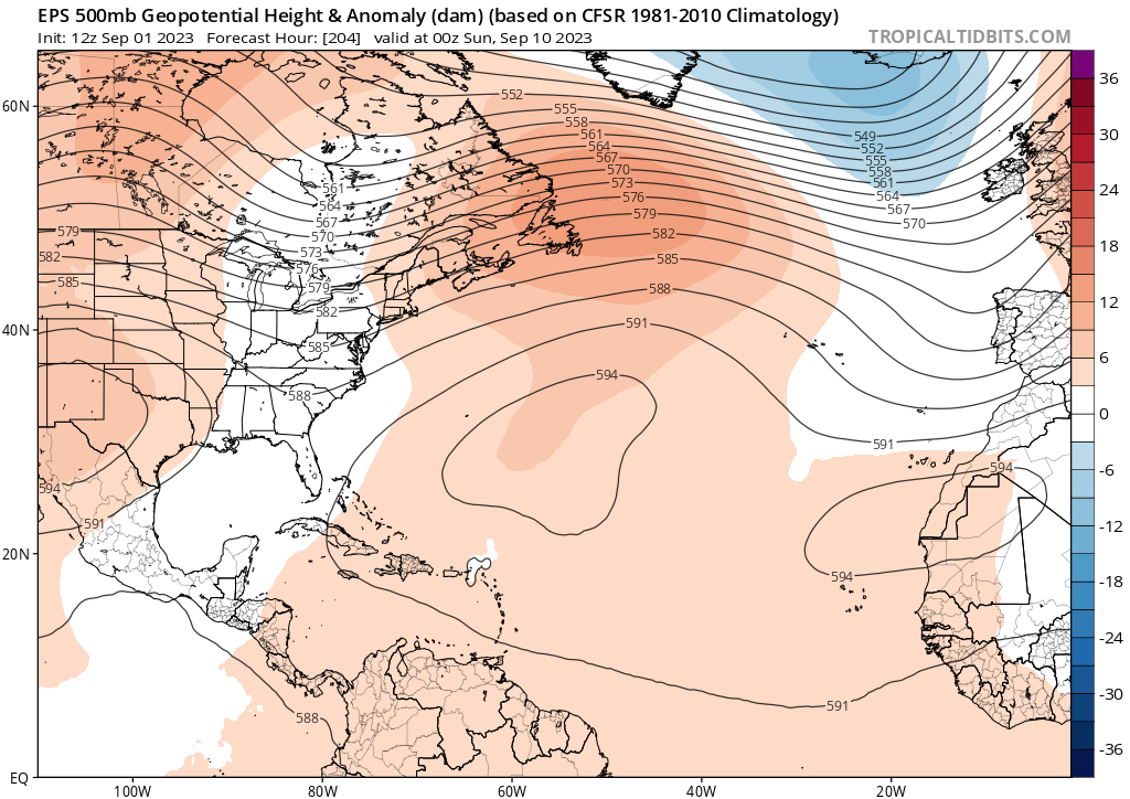
That solution would require perfect timing, but everyone should be watching the strength of this Atlantic ridge. This is not a slam dunk OTS pattern IMO, even if that solution is still favored at this time, and if it’s a threat to the US I think it’s an EC threat rather than buzzsaw through Florida threat.
-
On a trip I took to GA to spend my birthday with family I abruptly told them I needed to go to Florida to chase Hurricane Elsa. I didn’t go to Buffalo for their epic blizzard was because it was the first Christmas after my dad passed.
-
It may very well remain no threat to land, but this is a very important reminder, visualized:
-

Wake Me Up When September Ends..Obs/Diso
WxWatcher007 replied to 40/70 Benchmark's topic in New England
Not our area but big flooding around Vegas. -
Wake Me Up When September Ends..Obs/Diso
WxWatcher007 replied to 40/70 Benchmark's topic in New England
Fantastic day outside -
It’d be hilarious if this struggled after my super bullish post In all seriousness though, I find it very hard to believe that easterly shear would overcome all the other favorable factors including peak climo to disrupt this invest to the point it’s weak across the entire basin, especially given how it looks currently on visible/IR. The overall environment looks excellent to me despite the early shear. Intensity also probably plays a role in track.
-
Yeah I think the steering pattern is a bit messy right now. We’ll see where things stand as this reaches the Antilles.
-
Yeah I started the thread on the invest on the main tropics page.
-
Gert came back from the dead, and Katia has formed. All eyes should be on 95L. Forecast has been excellent thus far. WxWatcher007 Peak Season Forecast (Aug 20-Oct 20) Named Storms: 13 (7) Hurricanes: 6 (2) Major Hurricanes: 3 (2) Emily, Franklin (MH), Gert, Harold, Idalia (MH), Jose, Katia
-
Totally agree. The troughing signal is going to be uncertain for at least another 7-10 days IMO. Get it to the Antilles and we'll see what things look like. Get it to the Bahamas and all bets are off. OTS favored until there's a strong EC signal. This one is a big dog whether it impacts land or goes OTS. CV major of yore.
-
Just updated the OP with an analysis
-
The NHC has designated our AOI in the eastern Atlantic as Invest 95L. It already has a good look to it, with significant spin and some disorganized convection. Normally, I am more muted when we're at the invest stage, but not this time. I believe this is the strongest signal we've seen for a long track CV major hurricane in quite some time. Why? The environment ahead looks tremendous not just for tropical genesis but significant intensification in the MDR. First, it's the moisture. Unlike early August, where SAL and subsidence dominated the MDR, we have a more moist and unstable environment thanks to the presence of much stronger preceeding waves scouring out the SAL. Look at the dramatic rise in instability in the MDR since August. It's more than enough, as we've seen. Obviously the thermodynamic environment is excellent. We have strong SSTs and OHC through the MDR and basin. With a strong ridge building in over the Atlantic, wind shear should initially be low. That alone is enough for TC genesis. There is a long runway of low shear in the MDR. (Edit: there are low trades initially, which means easterly shear, but I don’t think this will disrupt progression much after a few days) However, what sets this apart from other setups, especially in recent years, is that it looks like the orientation of the steering pattern is going to create ideal conditions for ventilation. From Eric Webb Folks, that's big time. All systems seem poised to allow for TC genesis, followed by an increasing level of organization and eventually, intensification. It's reflected on the guidance consistently. Each operational model has a strong system nearing the Antilles. With a strong ridge over the Atlantic, the Antilles have to watch very closely, including Puerto Rico. Once this gets to the Antilles, as you can see above there is a lot of guidance that tries to round this around the ridge. All bets are off then, as we turn our attention toward the East Coast steering pattern relative to the Atlantic ridge. Climo always favors OTS at this stage, but given the presence of strong ridging showing up on the guidance, this may be one that we're watching for a while, especially as guidance tends to underplay the strength of ridging. This is also where we need to watch the orientation of troughing in the eastern US, but that'll be at least 7-10 days away. At the very least, this is likely to be a threat to the Antilles and a significant ACE producer. In my estimation, 95L has the best chance to be the strongest TC in the basin this season.
-
2023 Atlantic Hurricane season
WxWatcher007 replied to Stormchaserchuck1's topic in Tropical Headquarters
Yes, that’s definitely true, but what I think is different here is strong consensus on the first big Atlantic ridge over the basin keeping this west. That’s enough to get it to the islands. All bets are off after. It’s way too far out, but just having the above ridge on the ensembles is problematic imo because the guidance has been underselling the ridges we’ve seen thus far. I’d still think that troughing over the E Coast could be around for a late kick, but you never know.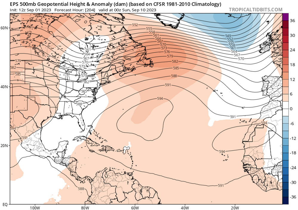
-
It’s as close to a MH lock as you’ll ever see, which means I was probably too conservative with my peak season MH forecast. I don’t think that’s it before October 20.
-
2023 Atlantic Hurricane season
WxWatcher007 replied to Stormchaserchuck1's topic in Tropical Headquarters
It’s as legit a pre-genesis signal for a long track major hurricane as I’ve seen in a while. No guarantees it stays OTS but I’d probably favor that at the moment just given climo. -
Wouldn’t be surprised. Given that an ERC was happening, it was a really interesting eyewall with a lot of spinning. The damage survey after had a lot of trees snapped.
-
Wake Me Up When September Ends..Obs/Diso
WxWatcher007 replied to 40/70 Benchmark's topic in New England
Well, nobody in New England should ever expect a direct hit until an eyewall is over their house. I’m just talking about the CV signal. -
2023 Atlantic Hurricane season
WxWatcher007 replied to Stormchaserchuck1's topic in Tropical Headquarters
From a legit dead basin to this. Buckle up folks, I think we’re rolling through the 20th. -
Been a while. Maybe not since 2017?
-
Regardless of whether it makes a close approach to the US, it’s a classic long track CV signal.
-
Wake Me Up When September Ends..Obs/Diso
WxWatcher007 replied to 40/70 Benchmark's topic in New England
The long tracker is coming. -
My video from the storm. Damage survey video tomorrow.