

schoeppeya
-
Posts
579 -
Joined
-
Last visited
Content Type
Profiles
Blogs
Forums
American Weather
Media Demo
Store
Gallery
Posts posted by schoeppeya
-
-
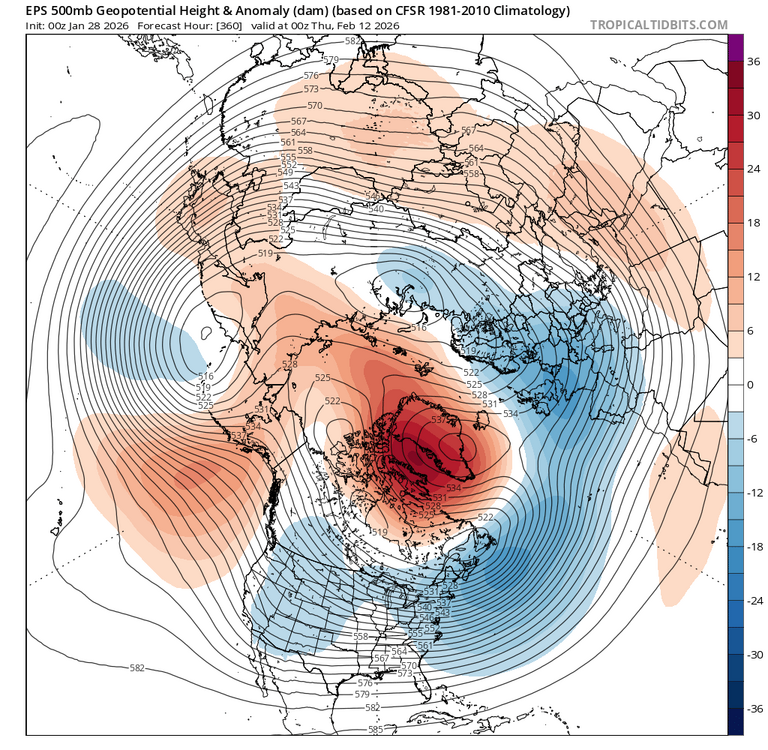
Pretty incredible PV split the GFS is trying to show:

-
2 hours ago, snowman19 said:
Clueless. You contribute nothing to this forum besides being a troll. Never have. I challenge everyone to go look back on all of your posts and find anything at all meaningful and productive you’ve posted. A completely useless, worthless member. You’re also not very smart.
And I love how @brooklynwx99 put a laughing emoji on your post. Probably the worst weenie meteorologist I’ve ever read in my life. He shouldn’t be laughing at anyone after all of his epic busts since the 21-22 winter. I’ve lost track. Constantly predicting historic, best pattern ever, textbook, guaranteed KU coastal snowstorm patterns, which DC-PHL-NYC hasn’t seen since February, 2021. Dreadful. Always hyping monster snowstorms and failing, just like JB
That's exactly the response I expected from somebody who results to insults and name-calling every time somebody disagrees with them. For the sake of not derailing anything I will leave you alone, but after you've been horrifically wrong on every "forecast" you've had for this winter, I would suggest a little situational awareness and a little more humility in your approach, for those of us just trying to learn from the "smart" people it makes the thread really hard to read.
-
 8
8
-
 1
1
-
-
6 minutes ago, MJO812 said:
It was weakening. Dude I wouldn't be talking if I was you and you always have to tag someone because your posts were horrible to start winter
To start winter? I think he posted like two weeks ago we were having a classic front-loaded winter just before a massive winter storm materialized.
-
 6
6
-
1
-
-
1 hour ago, EastonSN+ said:
Block still showing up
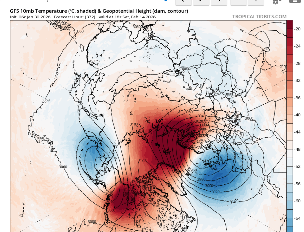
Yeah also thinking the 500 mb pattern on the ensembles suggests more coast to coast cold as opposed to the west torching and the east way bn. Should be a fun period.
-
1
-
-
Where'd @snowman19 disappear to
-
1
-
-
Round 2 performed here, I measured 8.5 in my yard and I would bet 7 inches of that came last night. Always will be the what could have been if round one hadn't been a dud and we hadnt sleeted most of the afternoon yesterday but 8.5" is a huge storm here and I will take it.
-
Just now, stormdragonwx said:
Yeah I am totally over this storm. Looks like it's gonna stay sleet with an incoming dry slot.
Looking around at current storm reports it does look like a lot of areas performed within expectations for round 1 with a lot of 5-6" reports both north and south of Tulsa... just specifically my area (Jenks/Bixby) up 44 into missouri are the low end spots with a lot of 2 inch reports.
-
16 minutes ago, MUWX said:
I’m not really sure what to make of radar right now. There is a pretty big hole in the precip shield right down 44 in Oklahoma.
Dry air pockets everywhere and the precip shield back into Texas is decreasing in coverage and intensity not increasing. Becoming less and less optimistic that wave 2 is going to perform let alone over perform.
-
48 minutes ago, MUWX said:
It’s just not really the heavy snow that Mets have been hyping up. Dry air is probably not the right term, but it’s also not what’s been advertised for days.
Yeah that image the HRRR is showing at max .5 inch an hour rates for a couple hours... never truly get up into snow+ on the HRRR for all of round 2. The 3k nam and GFS still show hope so we will see, im leaning dry air wins at this point.
ETA: I still dont think the HRRR is initializing the current convection well, maybe something to note. 3k nam was way closer to actual radar.
-
HRRR is starting to show dry air issues for most the region for round 2 tonight... I know the fat lady hasnt sung yet but starting to look like an absolutely epic bust.
-
 1
1
-
-
8 minutes ago, The Waterboy said:
Mesoscale Discussion 0044
NWS Storm Prediction Center Norman OK
1034 AM CST Sat Jan 24 2026Areas affected...Portions of West Texas into central Oklahoma
Concerning...Winter mixed precipitation
Valid 241634Z - 242030Z
SUMMARY...An expanding area of mostly sleet will continue northeast through the afternoon.
DISCUSSION...An area of showery precipitation continues to expand from West Texas into southwest Oklahoma this morning. The precipitation coverage is already more expansive than shown by any 12Z guidance and it continues to expand.
Thats the precip area I was referencing, pretty impressive on radar
-
1
-
-
Sitting about 2" in south tulsa, I think its going to take a significant overperformance in round 2 to get us to the double digit mark but the radar over sw oklahoma and texas is certainly more impressive than what the HRRR has modeled so I have hope.
-
12 minutes ago, MUWX said:
It would really be something if the GFS pulls the upset here. It’s sure sticking to its southern idea.
Its on an island and getting to a range where the cams start having more weight... its really been pretty terrible with this system since pretty early on.
-
All of the 0z suite coming in with higher totals this evening as we are less than 24 hours from the show starting... really thinking 12-20" is possible in Tulsa.
-
We have had so many of these storms bust throughout the years I am trying to temper my excitement but cant lie, models holding serve and even increasing amounts at 48 hours with the new data is starting to make me believe 12-18 inches is possible in Tulsa.
-
1
-
1
-
-
52 minutes ago, snowman19 said:
“30+ days in MJO phase 8 in December”. One of the best doozy’s of all time from you. Stick to arresting perps in the Bronx
You know its possible to disagree with somebody without being a complete d*ck right?
-
2
-
1
-
-
True kiss of death on a return to colder pattern is the cold air in Canada getting washed out, dont see any signs as of now.
-
12 hours ago, MJO812 said:

Not possible, I was told it was a foregone conclusion that the PV was going to be strong by mid month and we were going to torch.
-
1
-
1
-
-
8 minutes ago, 40/70 Benchmark said:
Sure, it can be argued that perhaps that PV will recover more slowly than some are implying, but I think interpreting that subtle weakening around Xmas as a major disruption is what is insane...especially on the heels of this current head-fake. December reversals are exceedingly rare, which is why reflection events are so common place in January and February.
I must have missed where somebody did that?
-
1
-
-
56 minutes ago, snowman19 said:
What are you trying to prove? Nothing has changed, this is still a classic wave reflection event then a recovery and strengthening of the SPV come mid-late December. Even twitter has moved on. We’ve discussed this on here ad nauseum with @40/70 Benchmark and several others. We’re beating a dead horse
Acting like a forecast for 2+ weeks into the future is a foregone conclusion is insane. Think its fair to post a forecast that might show things trending differently than they are being shown now.
-
 1
1
-
-
50 minutes ago, GSwizzle83 said:
Sorry if my post was confusing. I meant that compaction was an issue because of the size of the flakes and not that the flake size led to solar radiation lowering totals. For example, just saw the SGF recorded .75" of liquid equivalent yet only had a little over 6" of snow.
Was definitely low ratio, fine sand snow here as well.
-
1
-
-
1 minute ago, MoWeatherguy said:
Below is the Euro from 12z Sunday. 10:1 map. It's still high in places but much more in line with actual results.
Yeah the issue with that is at 10:1 that would have still had me at .43"qpf and I have a quarter of that.
-
SGF reported 3.5" at 6:00, just a stunning bust. The 00Z NMB last night was almost 12 inches. Hard to comprehend how everything missed that badly 12 hours from the start of the event.
I have a screenshot of the most recent HRRR run at 7 this morning still showing 9” for Tulsa and I have MAYBE 1” on the ground at my house.
As frustrating as it is for someone who loves big weather events, it’s one of the reasons I love it so much. As much as people want to think we have it figured out, there’s always reminders like this that Mother Nature will still do what she wants.
.-
1
-
-
Not going to drone on about it anymore but this is the worst modeling bust inside of 12 hours I can remember outside of a severe weather bust or two. Radar estimates have me at .1” QPF which is 1/4 the lowest amount any model had me at even as if 06z this morning.
.


2025-2026 ENSO
in Weather Forecasting and Discussion
Posted
Im a natural gas trader, you should look at the Feb contract. Went from being dangerously close to slipping below 3 dollars to rolling off in the mid 7's, feb was a wild ride.