

bristolri_wx
-
Posts
1,477 -
Joined
-
Last visited
Content Type
Profiles
Blogs
Forums
American Weather
Media Demo
Store
Gallery
Posts posted by bristolri_wx
-
-
-
I feel like the 10m wind charts are as accurate as the 2m temp charts…
-
3 minutes ago, OSUmetstud said:
An accordion plays, gently
“While My Accordion Gently Weeps”

-
 2
2
-
 2
2
-
-
I’m fine with it not getting stronger. This thing can keep moving east for all I care. The track right now is not great for where I am. Thankfully I have elevation off the water. However downtown Bristol is gonna be a mess from this. Including some flooding during high tide…
-
1
-
-
In all honesty, it was probably only moved 20 miles east... lol...

-
2
-
-
1 minute ago, Ginx snewx said:
NHC shifted east congrats GOn to Watch Hill
EAST EAST EAST EAST EAST EAST EAST EAST EAST EAST EAST EAST EAST
.
.
.
lol... -
Ugh... those of us contending the eastward trend on the models... it's not like we thought it was going to go east of Naragansett Bay... we just contend it wasn't going to make landfall in western CT or NYC... jesus... sometimes the made up narratives are fascinating... like the "conflict" is required part of the discussion lol...
-
1
-
-
1 minute ago, HoarfrostHubb said:
I was told this would be worse than Sandy….
I’m very disappointed
I don't think that person has posted in this thread in a while... lol...
-
 1
1
-
-
LOL the discrepancy on who cares about this storm is as diverse as the modeled LF tracks. In all seriousness there's probably much more interest in what this storm does for those of us in the coastal areas, especially areas that may end up east of the eye, then those further inland where it will be certainly falling apart pretty quickly.
-
1
-
-
4 minutes ago, Rjay said:

-
1
-
-
Just now, NeonPeon said:
More comfortable digs.
True... but they could have camped out at some nice places on the CT coast as well...
-
1 minute ago, ORH_wxman said:
This is true. Our grid sucks where I am currently.....but CT seems on another scale up though. We saw the massive contrast in both Irene and the Oct 2011 storms too...like towns right next to each other on the border...the MA side would only have scattered outages and the CT side would be like 90-100% out.
This could also be because the grid has weird boundaries with the way the power flows. Most of the towns on the border in RI don't have direct connections with the towns in MA. You think it would in 2021, especially when the same company owns the distribution lines on both sides of the border.
-
1
-
-
1 minute ago, DotRat_Wx said:
Cantore and Wolf in Newport RI. Make of that what you will
Rut roh...
-
Just now, Quincy said:
Yeah, that wording is suspect. How often does I-95/395 see power outages from nor’easters? Sure, there will be a lot of power outages, but that scale seems to imply it will be the worst on record or something.
It's just hard to tell. Obviously this won't be the strongest hurricane to hit the area. But there's much more infrastructure now than there was 100 or even 75 years ago, and we're more dependent upon it than ever. Also, we never do well with strong south winds with fully leafed out trees. Maybe it won't be the worst but it's sure not gonna be good...
-
Just now, WxWatcher007 said:
Some decent 925mb winds there.

Ugh that f-ing blows... literally...
-
Just now, STILL N OF PIKE said:
Newport is jammed today and the town Already closed all the beach parking lots as well as the road to “first beach “ that goes to sachuest point .
We park and walk like the rest of town
I work in Newport full time. It look me 35 minutes to get out of the city yesterday. It seemed to be a total s$%tshow of people trying to leave and people trying to get in at the same time, lol...
-
2 minutes ago, Baroclinic Zone said:
Hype machine in overdrive on that station.
Well it's "First Alert Weather". They must be first! Heck their on-screen graphics have it displayed 4 times.
-
1
-
-
Just now, Cold Miser said:
Yeah...She has been renting since June. Downtown
Call me biased but Bristol is one of the nicest places you can be.

-
1
-
-
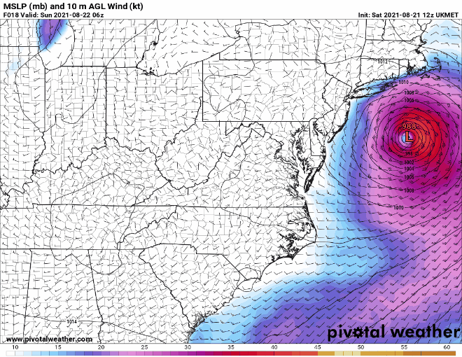
BOX 10AM AFD:
Quote.SHORT TERM /6 PM THIS EVENING THROUGH 6 PM SUNDAY/... Henri is expected to move into southern New England at some point late tonight into Sunday. Still expecting the axis of heaviest rainfall to be just west of the track. The strongest winds and surge will be to the east of the track. Still plenty of uncertainty regarding the exact track and timing, as evidenced by the slight eastward jog in the 00Z guidance. Probabilities favor a track somewhere between eastern Long Island and Block Island, before reaching the south coast of New England. Expecting rainfall chances to increase this evening, and should be going in earnest after midnight tonight into Sunday. Lots of factors leading to torrential rainfall rates; such as very high precipitable water values and a deep layer of warm rain processes. The big question is where will the heaviest rain occur? This is again tied into the uncertainty in the track of henri. Issued a Flood watch where we are most concerned for heavy rainfall and possible flooding. Based on the latest forecast, we expanded a Tropical Storm Warning into northern CT for a period of low-end tropical storm force winds. May need to consider further adjustments with later forecasts.
-
1
-
-
1 minute ago, Typhoon Tip said:
That's exactly what I was thinking Scott yeah.
I mean they're adding 5 mph to get the hurricane sash on this thing - okay. But I almost wonder if that's more ( you know ) part of the NHC's PR jolt to a distracted thankless population that doesn't deserve their service...
Seriously though, the so-so look at satellite: it is an interesting coincidence with some guidance trending back E. Internal monologue was thinking that may be because it is shallower and so not as deeply/fully integrated into the U/A circulation.
There's total distrust of everyone and everything now. If it was someone's or some groups plan to seed so much doubt into the population that they've brainwashed them into not believing anything, then they've succeeded. Even at a high end tropical storm there's gonna be people surprised about the damage caused...
-
1
-
-
2 minutes ago, Cold Miser said:
You in Bristol right now? My daughter is.
Right now - I'm in Providence at work at job #2, but it is where I reside (and have for most of my life).
-
2
-
-
3 minutes ago, Cold Miser said:
What causes the westward bias of some.of these models?
IMHO, (and this is probably over-simplified), if Henri is stronger, it gets pulled farther west by the cut-off low. If it's weaker, it stays a little farther east. I'm just basing this on the modeling trends over the last 36 hours...
-
1
-
-
Quote
Henri is moving north-northeastward, or 020 degrees, at 12 kt.  The
steering pattern appears fairly well established now with a cut off
low located over the central Appalachians and a ridge building to
the east and northeast of Henri.  This pattern should cause the
storm to accelerate to the north or north-northeast today followed
by a slight bend to the left on Sunday.  The latest run of the GFS
has shifted to the east, but overall the models are focused in on
landfall being between central Long Island and Rhode Island on
Sunday.  However, users are reminded to not focus on the center
itself, as impacts will extend well away from the center, especially
to the east.  The new NHC track forecast is a little to the east of
the previous one and very near the best-performing models, the
consensus aids.
-
2
-
-
1 minute ago, CoastalWx said:
Not sure convective allowing models are good for TCs. The same models in 2015 that PF used to bring snow as he rocked back and forth violently with Heady Topper in hand.
It also looks like that as soon as the convective models see weaker system development they kick it a little farther east...

Tropical Storm Henri
in New England
Posted
Yeah just misread the scale…