

bristolri_wx
-
Posts
1,478 -
Joined
-
Last visited
Content Type
Profiles
Blogs
Forums
American Weather
Media Demo
Store
Gallery
Posts posted by bristolri_wx
-
-
1 hour ago, DavisStraight said:
My pack is down to 3 inches, hopefully it freezes solid this week and forms a good base coat.
My pack is gone, except for a few piles from shoveling.
 It's been mid 40's here most of the day...
-
3 minutes ago, IowaStorm05 said:
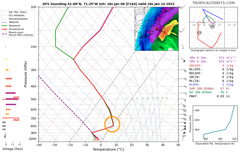
That sounding looks to me like it shows about 9 degrees celcius.
Not sure how... 10c is the next set of dotted lines to the right. The temp scale is at the bottom...
-
1 minute ago, 40/70 Benchmark said:
Snow/sleet line like 5 miles west of me...makes perfect sense

Don't get too depressed yet, highly unlikely that forecasted warm layer verifies like that...

-
1 minute ago, 78Blizzard said:
How is this even possible at the surface given the temps above? Or is there some sneaky layer above 0C?

Hits like 33F at 800mb... just barely...
-
 1
1
-
-
14 minutes ago, IowaStorm05 said:
I don’t even remember the last time we got one of those clippers.
Wasnt them clippers a big thing from like 2003-2005? I do recall several snow events that clipped the coast with light snow while Woonsocket was cold and dry.
I'm not that good at keeping track of them personally. I remember a lot of them when I was growing up (80s/90s) - a lot of 2-4" or 3-6" south of Providence and 1-3" north of Providence maps on TV when those storms would come around. Usually they would perform as expected.
-
5 minutes ago, NeonPeon said:
Good lord that is typical. I ended up with about 3.5 inches. Cement then a powder puff on top. Drive in any direction and the snow immediately gets deeper.
Sorry man, Newport is never in a good spot, except for some of those redeveloping Alberta clippers that shoot by directly south of New England... not much better up here. We usually get 125-150% of whatever Newport gets in most situations.

-
3 minutes ago, 40/70 Benchmark said:
I graded this effort an A-.
Although the forecast philosophy never wavered from the notion of a major storm (frustrated posts on a message board not withstanding), in the end the flaw with the forecast was that I was not intensely concentrated enough with the area of deformation.
https://easternmassweather.blogspot.com/2022/01/verification-of-friday-major-winter.html

It seems rather difficult to even figure out where that deformation band sets up in New England. It's different just about every time with these storms. It's also why we will never be able to predict snowfall to the inch - you get into the larger predictions and the range needs to be larger to account for the bands. It may take another decade of modeling resolution increases to get close to that point. I thought your forecast was on point and 6-12 seems valid for most of the area. The Cape busted high because that band was really juicy at the end and temps did not get quite as warm as expected.
-
1
-
-
16 minutes ago, TheSnowman said:
10". And like December 2019, I'm just a John Daly solid drive on the 18th from the coveted foot.
This is now the 4th Storm in the past 3 Seasons where I got Under a Foot when everyone around me got a Foot-15", OR I got 12" when everyone around me got 15"-20". This is just a losing spot. It Used to be a Magic spot from February 2003-2011 (and some few times after, specifically my Only Jack in March 2019) Where the NWS Literally would NOT Believe my Snow Totals. Now I don't even have to report because the towns next to me have 2" more so it's worthless. ALSO Miss time on TV as I know the RI Mets. But I'm not going to Lie and inflate the total to get on air.
Stop making RI look bad lol. Be happy with the 10". It's not a widespread 12" amount. Cumberland/Woonsocket is almost always in the higher end for RI.
We barely have 6" down here and I'm only 22 miles away.-
3
-
-
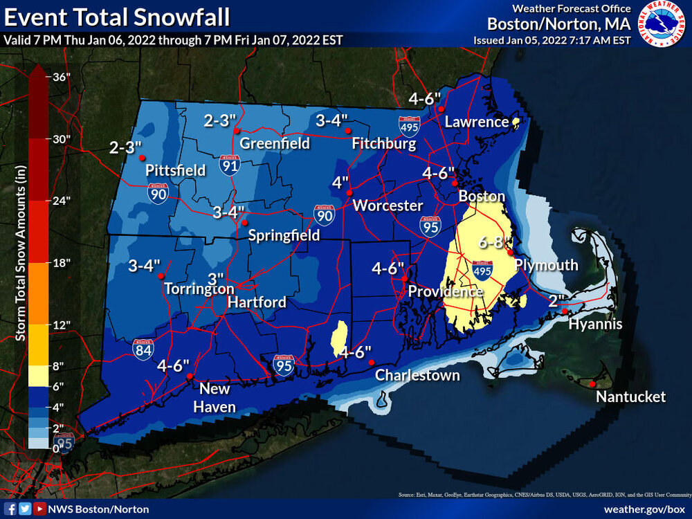
About 5-6" here in Bristol. What I expected. Probably same QPF as others but not quite as fluffy as others have reported which probably caused lower snowfall total. Still coming down moderately here in this last exiting band...
-
3 minutes ago, Kitzbuhel Craver said:
That depicts an absolutely frigid coastal. Been awhile since we had one of those…
Not sure if there's enough cold air around for that one to be all snow.

-
 1
1
-
-
2 minutes ago, NeonPeon said:
What's your total so far? My snow is melting as fast as it accumulates at the moment. Still don't have an inch.
Honestly, I'm more angry with myself more than anything. A while back I started just looking at all the modeling, seeing what people on here thought, and then arriving at a very conservative number, the lowest of possible bounds. Then, I cut that number in half for Newport.
Every winter I have to relearn the lesson.
I’m eyeballing 4” haven’t found the yard stick yet to measure. It’s 29 degrees here no issues sticking to the ground.
-
14 minutes ago, The 4 Seasons said:
it doesn't snow in Rhode Island
Yes, it’s due to the East Bay/West Bay de-snowification zone.
-
14 minutes ago, bishbish777 said:
So..is the FV3 any good? Because the 00Z run is pretty nice..
I believe it’s based off the same core as the GFS. It’s slated to replace the NAM in the next couple of years. I bet @OceanStWxknows more. I’ve been looking at it since it’s become available and anecdotally it’s seems to be an improvement over the NAM.
-
1
-
-
2 minutes ago, TheSnowman said:
You guys are Freaking Brutal


Cheer up your part of the state usually does pretty well in this sort of setup. Maybe you won’t be the New England jack pot but there’s a good chance you could be the RI one…
-
13 minutes ago, NeonPeon said:
If you draw a line through the middle of RI as far as its longitudinal boundaries, it won't split the state in half in terms of land mass either, because the state isn't a square.
Luckily? Glacially, the bay already does that, and it does a serviceable job of splitting the population, since almost nobody lives in the Northwestern half of the west bay.
I've been living here for over decade, and I've never heard anyone speak about east and west with regard to RI other than in terms of relation to the bay. Perhaps this is something that people on the west bay do, but people on the east bay don't. Which would only underscore the valid distinction, haha.
I don't think Charlestown is in the best place for this, but you're in a good spot and don't have to fret the P-type as is our wont. Enjoy the snow over there. I feel like early January snow is almost a bonus here.
I was born in RI and have lived here all my life. While East Bay is a commonly used term, no one really uses West Bay to describe anything in the state.
-
I wouldn't trust some of the snow maps honestly at the moment - not because they are giving us bad news, but because there is some model weirdness going on. The GFS sounding has the temp rising 7 degrees to 35 at the surface as the storm has passed us to the ENE with winds coming out of the NW and thicknesses between 516 and 520 over head. That's just not happening - its not common sense weather. And that type of output is going to affect snowfall map output. It's not going to rain over my house with 850 temps -18C, yet that's what the surface output on the GFS says is happening.
All I'm saying is that there's a lot of doom and gloom here, but there's a lot of model spread still and a lot of weirdness going on. 2-4" and 3-6" seems realistic and probably at this point. I guess it sucks that we're not getting a 12", but after last week's garbage I'm surprised we're even getting this...-
1
-
-
Ignore the models that are flip-flopping, and stick with the models that are consistent. NAM is wavering back and forth on this one, especially the 12k. Keep it lower on the list of consideration. Not a wish-cast here, just seems like common sense.
-
1 hour ago, PhineasC said:
I said a couple days ago we would soon be hearing:
"Still a couple inches for the Cape."
Almost there.
Why? The modeling has improved since 00z, not the other way around. The trends have been better...
-
Not too shabby... seems reasonable...
-
1
-
 1
1
-
-
12 minutes ago, dryslot said:
This is the time frame on the GFS upgrade where it saw some improvement and outscores the Euro, I guess we shall see.
The GFS and the FV3 Hi-Res were garbage on yesterday's "storm". Yes new storm new analysis, but if it's a pattern related issue, then it may not be as trustworthy as we would like.
-
A 3-6” event would be great. Not every storm needs to be a 12”+ event. Also, anecdotally, I feel like the mechanics required for 3-6” and 4-8” events are much easier to get widespread across most and/or all of New England, including the South Coast. Often the most amplified solutions have mixing issues or miss a chunk of the region.
Even in the “holy grail” season of 2014-2015, my neck of the woods only had about 60” of snow. While most portions other portions of New England were at 100” or more especially eastern areas.
Let’s get the ball rolling here and hope for warning level snows and go from there!
-
1
-
-
36 minutes ago, ineedsnow said:
Box will probably cancel advisories and the warning on Nantucket soon what a bust for them
It was always going to be close there. Even the HRRR was showing a decent bout of snow there until very recently. Might be a few hours before they decide to abandon them entirely... it was a close call, but going with a warning instead of an advisory was probably the call to make based on the forecasting tools available.
-
10 minutes ago, TauntonBlizzard2013 said:
I love how yesterday “this is coming west, nothing to stop it” and today it’s “ it’s going to be shredded and southeast, fits the pattern”
The models are clearly having issues with this overall winter pattern. This is going to be a tough forecasting season. I’m sure there are “improvements” using 500mb “verifications” though lol…
-
1 minute ago, ORH_wxman said:
We became unbearable at some point in the 2010s....nobody in here ever canceled winter in December or early January....only Ji did that in the M.A. forum. Now we get it multiple times per winter in here.
People can’t even figure out which potential storm this thread is for lol…
-
1
-


Met Winter 2021 - 2022 Banter
in New England
Posted
Yeah winds have been gusty here all day too.