

bristolri_wx
-
Posts
1,486 -
Joined
-
Last visited
Content Type
Profiles
Blogs
Forums
American Weather
Media Demo
Store
Gallery
Posts posted by bristolri_wx
-
-
6 minutes ago, Baroclinic Zone said:
fyp
FYC…
") Sorry I see what you did there to my post. FV3 has had the toughest time…
Sorry I see what you did there to my post. FV3 has had the toughest time…
-
 1
1
-
-
FV3 based models have had a tough time with this one…
-
1 minute ago, TheSnowman said:
Wait - RAY IS BULLISH AGAIN?? OFF of What??
I’ve already called every airline in the US and homeland security to mark you with a cannot fly tag. Seriously the only time our forecast goes to shit is when you start planning to come back to RI. You cancelled your plans and suddenly the models improve again. STAY IN LA!

-
3
-
 3
3
-
-
My apologies if this is off topic…
As we hit 380 pages on this thread, and we wait for the 18z Euro, I just want to express my gratitude to everyone who participates in these threads. The community here is incredible, and I learn a little more with every storm. Plus the humor and drama can’t be topped. I lurked a while before joining, and then lurked more before easing myself posting, and now this place is part of my daily routine, especially during the active weather months. So thanks to everyone who makes that possible here, regardless of storm outcomes.
Now back to our regularly scheduled bi-polar model reaction, already in progress.
-
27
-
 1
1
-
-
3 minutes ago, dan11295 said:
I am certainly not a pro met, but it would seem upping totals at this stage is simply not supported by guidance.
.
A forecast needs to be issued. Some of the stuff came in while they were probably issuing the forecast. For newscasters, they will have another model cycle before 11 pm to look at, as well as Radar and satellite.
They will probably issue updated forecasts this evening if trends continue and actual weather conditions warrant it.
-
1 minute ago, skierinvermont said:
The models are the science. Nobody looks at a satellite image and says it will snow two feet tomorrow. The models tell us that the mid level features might get strung out and shunted east more than previously thought.
Models aren’t perfect as they are programmed by humans.
-
4 minutes ago, dendrite said:
Eh…sometimes you have to listen to the models when you’re inside 24hr and all of these runs from models with slightly different physics and parameterizations show the same basic idea.
True. Then we have a problem if we can't predict what a major storm is going to do that affects approximately 58 million people within 12 hours of it starting.
-
16 minutes ago, Ginx snewx said:
Never implied that was me
I'm thanking all veterans.
")
-
29 minutes ago, Ginx snewx said:
You can pick out the veterans here easily. Not mentally exhausted, don't freak out every 6 hours.
Thank you for your service.
-
4
-
-
Light snow here for several hours in Newport. Sticking now, 31.
-
Just now, Greg said:
I was going to say something positive that I saw but don't really want to start an arguement.
We are all friendly in here. Post what you want.
Also, FU… :-)
-
5
-
-
It’s been lightly snowing here in Newport most of the morning. That’s a good sign in my opinion. The big ones, when summarized, always start out with light rain, drizzle, flurries, etc before all hell breaks loose. Totally unscientific analysis here, but I’m not fretting the Euro changes too much at the moment but do feel bad for those on the edge…
-
1
-
-
4 minutes ago, JC-CT said:
A NCAR employee saying that the grid resolution of the model that beats the US's own nwp month after month after month shouldn't be used is kind of rich, tbh.
I don't believe that's what the NCAR employee is saying...
-
3 minutes ago, PhineasC said:
Quad lows next winter.
Cool, I'll get the lows in sync with my quadraphonic Blaupunkt in my Porsche 911.
-
1
-
-
5 minutes ago, Typhoon Tip said:
This is really turning into an intolerable situation for the MA offices, up through NYC ... This series at 12z basically removed them from even winter storm warning criteria - arguably .. - yet they were cooked into believing a blizzard was en route. They have blizzard headlines down there that frankly, don't have a prayer at verifying "IF" this 12z Euro had any say.
And if these are right solutions - the elephant in the room is that the models, et al, could not get this right at 30 hours -
although, does the GFS re-enter the discussion there? I dunno - might be right for the wrong reasons in that case... separate headache.
Yeah. You can't blame them. If this does end up going sideways, then someone needs to figure out how we can get these models to be more in the ballpark on this type of weather event in the future. Yes, I know "these are tools and you need to know how to use them", but at the same time, I feel confident there's highly trained mets throwing shit in their offices wondering how the hell are they supposed to forecast with so many changes to the data 6-12 hours from when the storm is supposed to start based on location. I can't begin to imagine the amount of data that I don't have access to that there is to analyze when this is your trained profession and job to do.
This isn't me melting - I think modeling is fascinating, and it's always interesting to me when they take a dump, especially very close in to an event. This is probably why NWS has been trying to be conservative with forecasts while we have been following along here.-
2
-
-
-
3 minutes ago, dendrite said:
It'd be nice if ECMWF could speed up their product output by even 30 minutes. Are they running 4dvar on a compaq presario?
Nah don't forget they are in the UK so they are running it on a cluster of BBC Micro's.
-
1
-
-
1 minute ago, RUNNAWAYICEBERG said:
Stepped away for some work and the train wreck came as expected, right on time. The euro just might finish it and send everyone outside of EMAATT off the bridge.
Gut feeling is it's in the same ballpark as 06z. It really hasn't budged much, just wobbles.
-
4 minutes ago, 78Blizzard said:
We did say last night to wait another 24 hours before doing high fives.
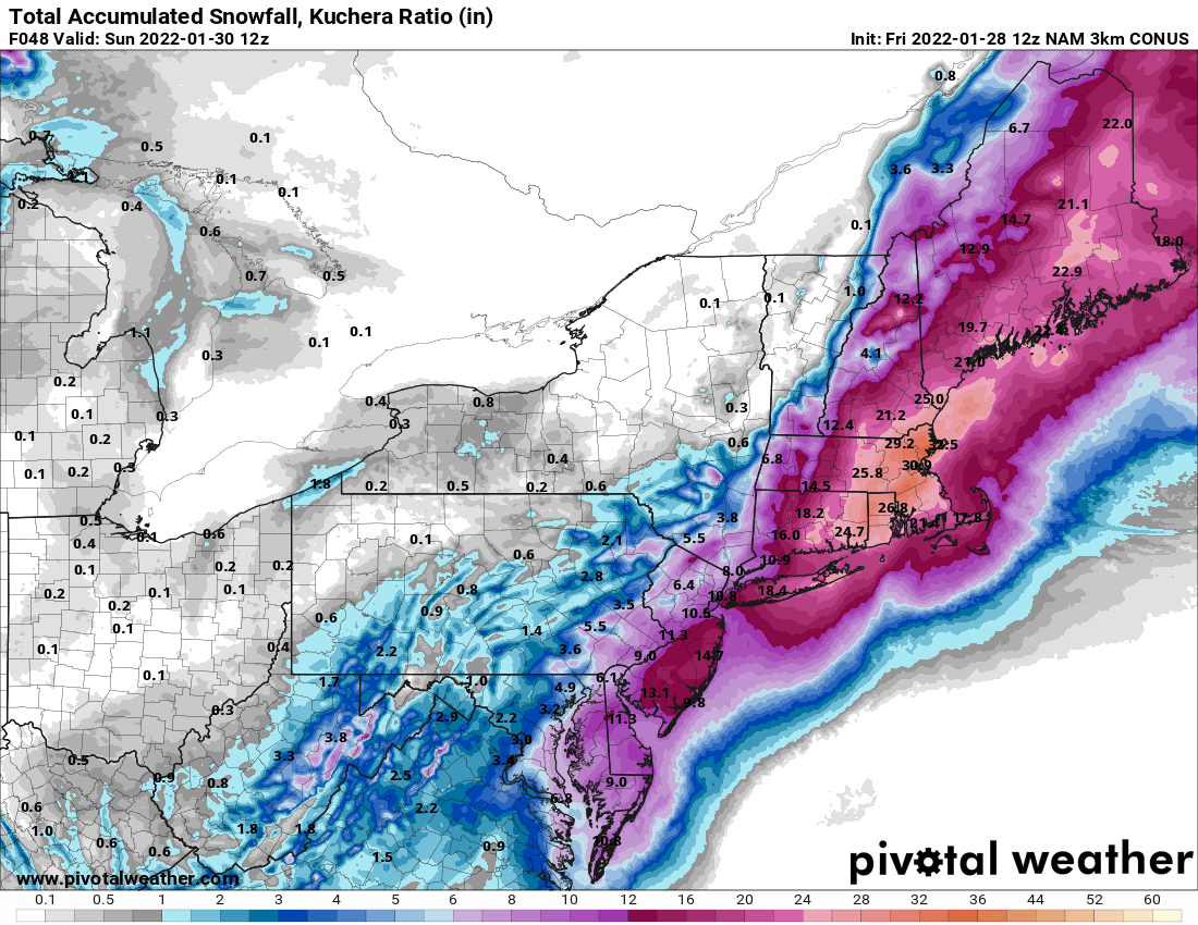
Those GDPS/GFS maps are getting better... and still have two more cycles to do so... and you can assume 10-1 won't cut it, as every single met has said there will be higher rates, more like 12-1 to 15-1... maybe more... so more interested in QPF maps than snow maps with low ratios at this point...
-
-
Let's keep in mind that the 10-1 maps are not gonna be accurate for this thing. Neither is the Kuchera's, but somewhere in the middle is where we end up for ratios.
-
3
-
-
-
All the high-res 12z models are inching westward and upward from their previous runs. Feeling better about that even as we have other models wobble a little back and forth... the 3K NAM looks awesome as well, once you assume ratios in many places will be higher than 10-1.

-
4 minutes ago, NeonPeon said:
Shoot for the stars. If you fail, you'll still... post frothing rage, righteously indignant at the injustice of it all!
I forgot how the phrase goes.
I've been thinking 9 inches in my back yard for days. That'd be top 5 in my time here. I know that wouldn't raise an eyebrow elsewhere. Any more is gravy. I know plenty of guidance shows more. Once bitten, twice shy.
I think you're being conservative. It won't take much for us to get 12-18" out of this one. No p-type issues on any model for us. Considering someone somewhere is gonna get 24-30" to the NE of us figuring we get half of that isn't outlandish. Even the RI snow holes are over a foot on most of the guidance.


Powerful Multi-regional/ multi-faceted east coastal storm now above medium confidence: Jan 29 -30th, MA to NE, with snow and mix combining high wind, and tides. Unusual early confidence ...
in New England
Posted
I’m still skeptical on that. It would need to really be the perfect conditions. 12-15 to 1 is a more reasonable expectation and you still get a dumping of snow with that.