

bristolri_wx
-
Posts
2,082 -
Joined
-
Last visited
Content Type
Profiles
Blogs
Forums
American Weather
Media Demo
Store
Gallery
Everything posted by bristolri_wx
-

"Don’t do it" 2026 Blizzard obs, updates and pictures.
bristolri_wx replied to Ginx snewx's topic in New England
We may not see another blizzard of 78 in our lifetime. It's like the hurricane of 1938 of winter storms. The way that low tucked in and then closed off and stalled - yet all the other pieces fell into place in 1978 seems to have not come close to have been replicated since then. Today if we see a low that close to us on the models, we're thinking where is the mixing line going to setup! -
"Don’t do it" 2026 Blizzard obs, updates and pictures.
bristolri_wx replied to Ginx snewx's topic in New England
Not at all. That didn't even enter my mind. I'm thinking government waste and corruption, bridges falling down in disrepair, high taxes and cost of living. But if that's what entered your mind first, that's something for you to address, not me. -
"Don’t do it" 2026 Blizzard obs, updates and pictures.
bristolri_wx replied to Ginx snewx's topic in New England
It's okay to be disappointed, and put it down in words here. It's the tone that matters. I feel bad that the storm was not as prolific for others as it could have been. That being said, there's always winners and losers in these big storms. It's rare that everyone wins because what produces the snow on the north west side of these storms is banding, and it's almost impossible to have bands that cover our entire region to make everyone a winner. It truly is like going to the casino - only a few are going to jackpot. Usually for my area to win, somewhere else has just cashed in their last snow chip without a good return. At the end of the day, it's just weather, and we aren't in control of it. It's nice we see all four seasons in New England. I can't imagine, even when I get a 20" winter, living somewhere where you don't get the variety of weather you get here. -
"Don’t do it" 2026 Blizzard obs, updates and pictures.
bristolri_wx replied to Ginx snewx's topic in New England
Clearly you have angered the snow gods with your accordion playing debauchery and they have blown your snow to the far ends of Manville and Albion. You must sacrifice a virgin Victoria and repent to please the gods and fill in your snow hole. -
"Don’t do it" 2026 Blizzard obs, updates and pictures.
bristolri_wx replied to Ginx snewx's topic in New England
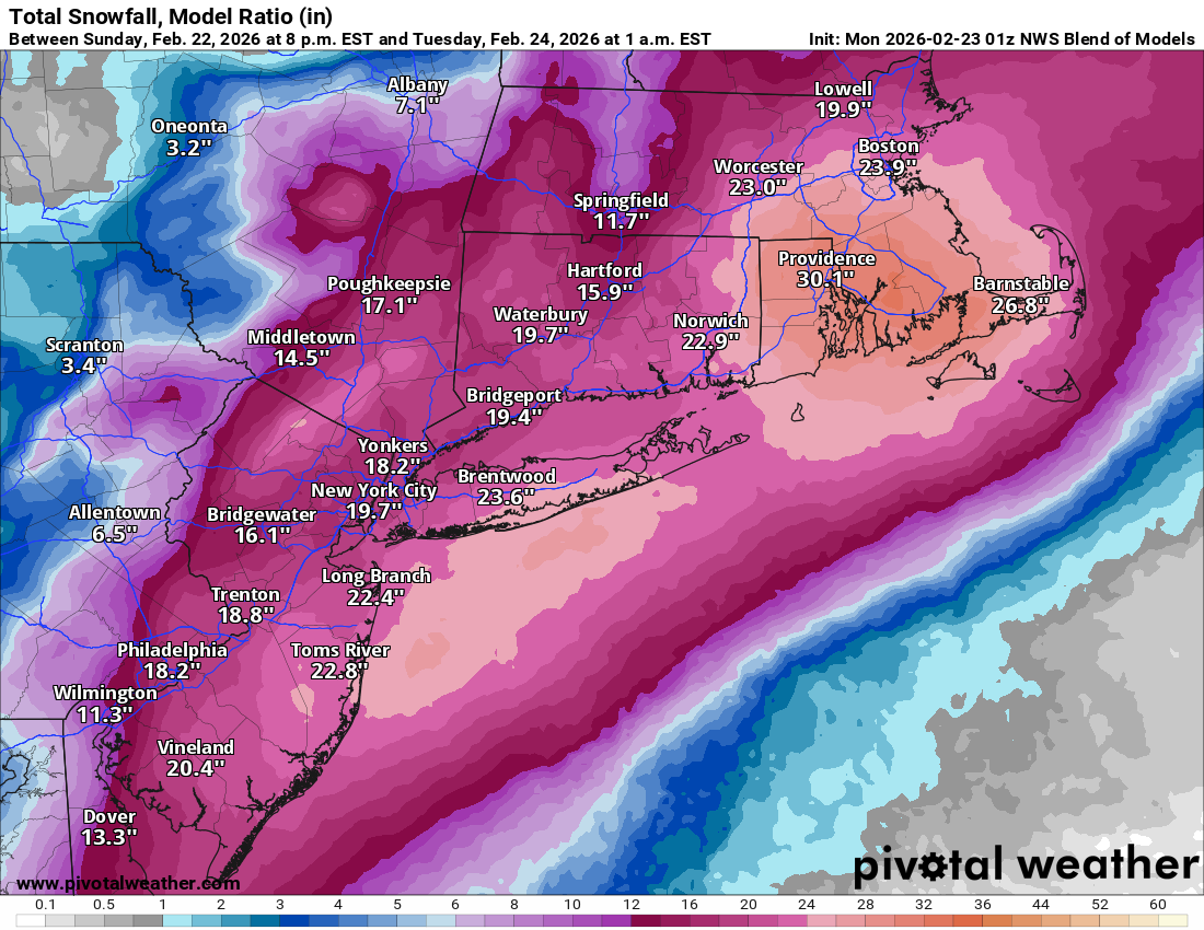
This may make it number 1 all time. I believe 1978 was around 27. -
"Don’t do it" 2026 Blizzard obs, updates and pictures.
bristolri_wx replied to Ginx snewx's topic in New England
If you don't end up at around 24" then it's only because you don't have a good spot to measure. Your location wasn't in the middle of the death band but you have several consecutive hours of 30 dbz stuff on radar, and some parts of the heavy band made it your way. I've got two personal reports of around 2 feet in Cumberland area from friends. Plus we have the reports from Attelboro, and I have a friend in Smithfield reporting two feet to the west of you. There was no prolific snow hole over your house. Even if we knock a few inches off due to drifting, there's a good chance that this number verifies. It's seriously time to relax now and enjoy what you got. We already have enough things giving RI a bad name, and your whining on this thread is insufferable. You don't know how many times I've had friends in the northern and western parts of the state with significantly more snow than my own backyard. There's 50,000 people with no power in the state, that may not get it back for a couple of days, and you're complaining you didn't get 40" on top of your fake fucking mountain. Seriously, get a hold of yourself, and at least melt with some world championship worthy dignity. -
"Don’t do it" 2026 Blizzard obs, updates and pictures.
bristolri_wx replied to Ginx snewx's topic in New England
This guy has a message for you....jpeg.c76f8c837a48dc7028723c2643bcabde.jpeg)
-
"Don’t do it" 2026 Blizzard obs, updates and pictures.
bristolri_wx replied to Ginx snewx's topic in New England
G19_sector_ne_GEOCOLOR_240fr_20260223-1120.mp4 -
"Don’t do it" 2026 Blizzard obs, updates and pictures.
bristolri_wx replied to Ginx snewx's topic in New England
CODNEXLAB-NEXRAD-BOX-N0B-20260223-1619-200-100.mp4 -
"Don’t do it" 2026 Blizzard obs, updates and pictures.
bristolri_wx replied to Ginx snewx's topic in New England

-
"Don’t do it" 2026 Blizzard obs, updates and pictures.
bristolri_wx replied to Ginx snewx's topic in New England
Totally astounded by the crush job here. Can’t even look outside to see what’s going on. It’s a movie-like. Probably a 50 year or 100 year storm for RI. Usually those 35-40 dbz bands don’t stick around for this long. Thankfully power is still on, though half the town is out. Officially changing my handle to 39/70 Benchmark after this one… -
"Don’t do it" 2026 Blizzard obs, updates and pictures.
bristolri_wx replied to Ginx snewx's topic in New England
It's insanity here. Greatful I still have power at the moment. 3K seems to have been with projecting heavy band locations - agreed. -
"Don’t do it" 2026 Blizzard obs, updates and pictures.
bristolri_wx replied to Ginx snewx's topic in New England
I don't have a level of expertise to explain it. Not sure it can initialize wrong for 8 hours straight. Maybe just a level of physics that's outside of the models understanding is occurring causing everything to be deflected southeast. It's something I would expect more from a global that a high resolution meso model. -
"Don’t do it" 2026 Blizzard obs, updates and pictures.
bristolri_wx replied to Ginx snewx's topic in New England
G19_sector_ne_EXTENT3_72fr_20260223-0656.mp4 -
"Don’t do it" 2026 Blizzard obs, updates and pictures.
bristolri_wx replied to Ginx snewx's topic in New England
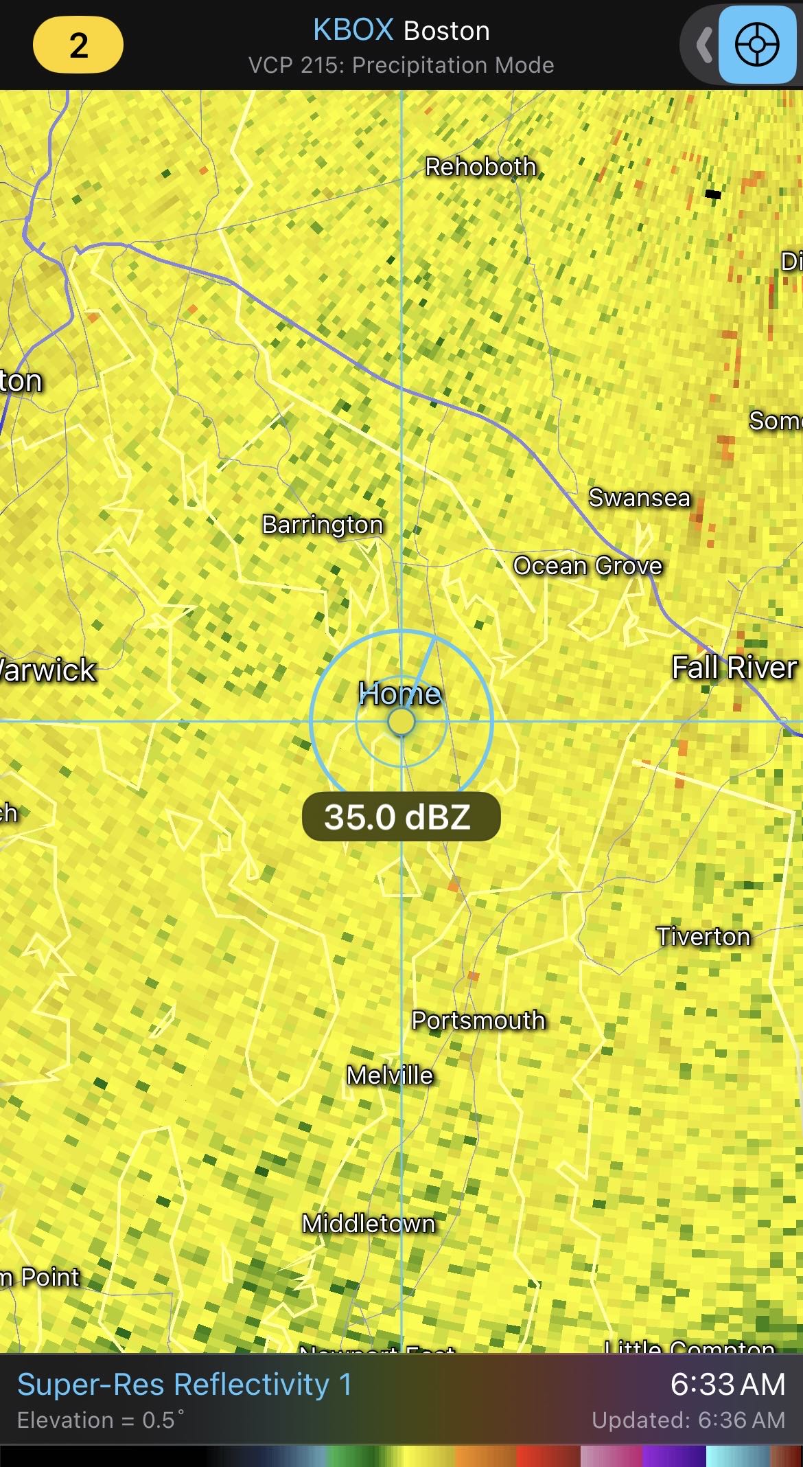
Not sure what the hell is wrong with the HRRR, but it's been wrong since 10PM last night with the placement of the heaviest bands. Total failure in terms of short term prediction of wtf is going on outside. In this case 40-50 miles is making a huge difference.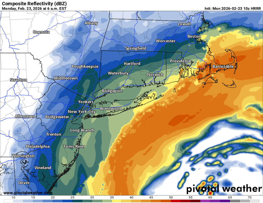
-
"Don’t do it" 2026 Blizzard obs, updates and pictures.
bristolri_wx replied to Ginx snewx's topic in New England
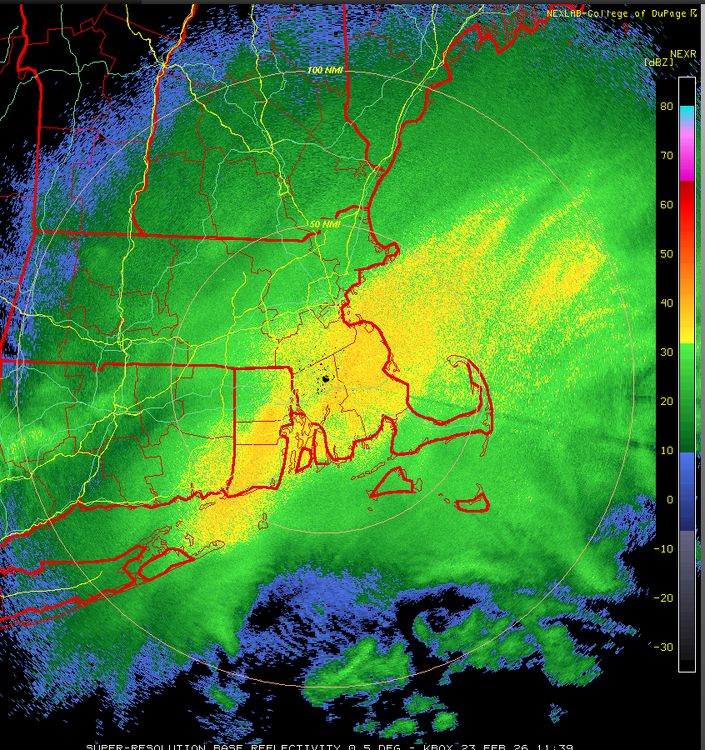
Don’t think I’ve seen radar like this over my house/area in any recent storm.
-
"Don’t do it" 2026 Blizzard obs, updates and pictures.
bristolri_wx replied to Ginx snewx's topic in New England
It’s crazy out here right now. -
"Don’t do it" 2026 Blizzard obs, updates and pictures.
bristolri_wx replied to Ginx snewx's topic in New England
CODNEXLAB-NEXRAD-OKX-DSP-20260223-0811-96-100.mp4 -
"Don’t do it" 2026 Blizzard obs, updates and pictures.
bristolri_wx replied to Ginx snewx's topic in New England
CODNEXLAB-NEXRAD-BOX-DSP-20260223-0809-96-100.mp4 -
"Don’t do it" 2026 Blizzard obs, updates and pictures.
bristolri_wx replied to Ginx snewx's topic in New England
3K mostly agrees... -
"Don’t do it" 2026 Blizzard obs, updates and pictures.
bristolri_wx replied to Ginx snewx's topic in New England
Damn straight. I have like 10 tabs open. BOX, OKZ, Regional Mosaic, Sub-Regional Mosaic, and the SPC Hourly Mesoscale Analysis map of 850 - 700 frontogenesis. But still looking at models too, with 15 hours to go on this storm. -
"Don’t do it" 2026 Blizzard obs, updates and pictures.
bristolri_wx replied to Ginx snewx's topic in New England
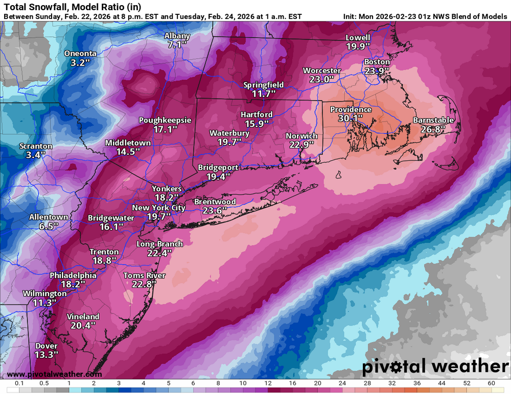
That being said - the NBM showed 30" right before go time. If that doesn't come close to fruition, NOAA/NWS really needs to take a look at what inputs it's using for snowfall. It's supposed to be one of the primary tools they use for issuing forecasts, from what I've read. -
"Don’t do it" 2026 Blizzard obs, updates and pictures.
bristolri_wx replied to Ginx snewx's topic in New England
Yeah I realized this after I posted. Need the 7z version, which ain't out yet. -
"Don’t do it" 2026 Blizzard obs, updates and pictures.
bristolri_wx replied to Ginx snewx's topic in New England
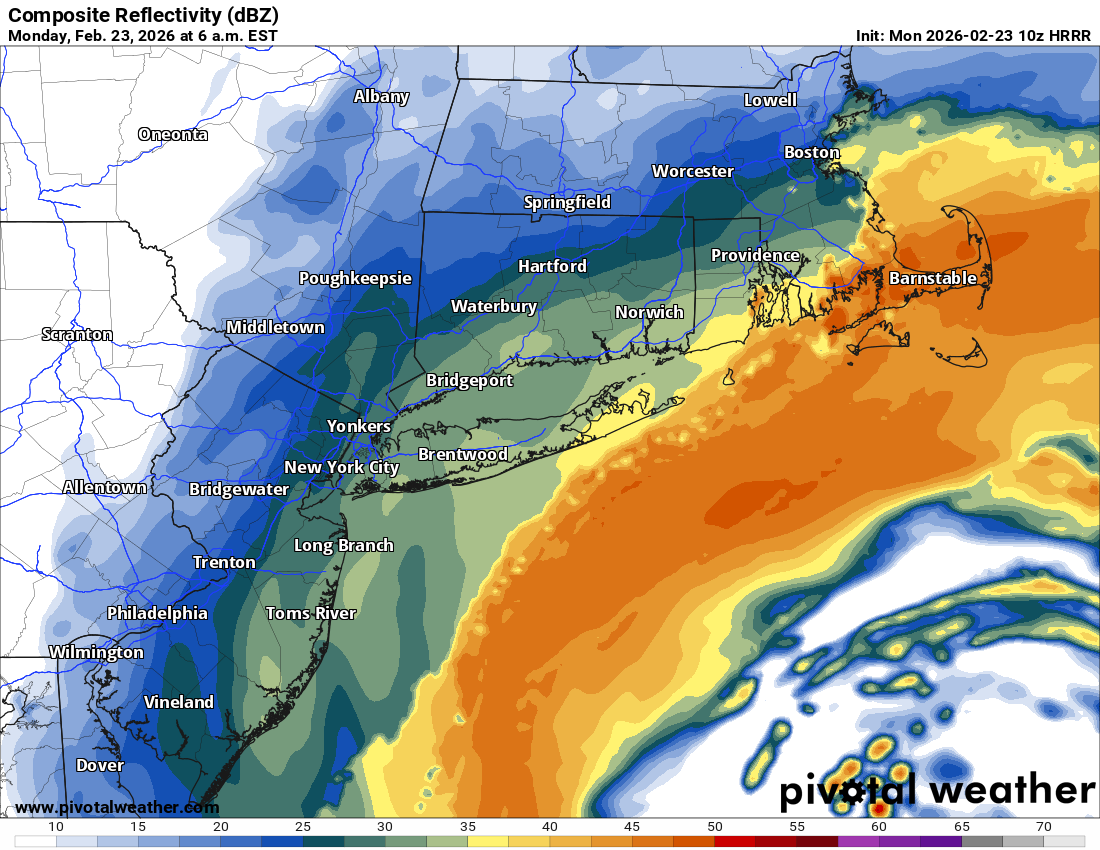
Not sure where this data is coming from, but the 1AM NBM continues to say game on.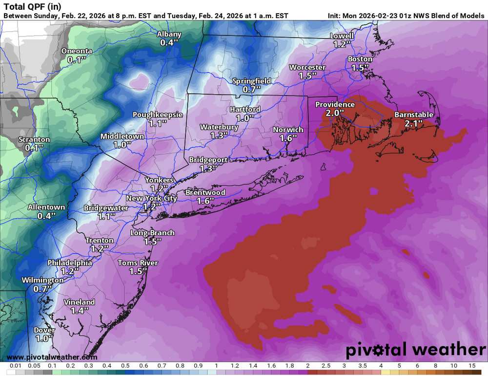
-
“Cory’s in NYC! Let’s HECS!” Feb. 22-24 Disco
bristolri_wx replied to TheSnowman's topic in New England
.thumb.png.4be4c9b44ab505c627fb6902f3ffaeff.png)


.png.c97f34830ef20472828c090eeae1c7e7.png)