hudsonvalley21
-
Posts
4,248 -
Joined
-
Last visited
Content Type
Profiles
Blogs
Forums
American Weather
Media Demo
Store
Gallery
Everything posted by hudsonvalley21
-
DCA _ NYC _ BOS ___ ORD _ ATL _ IAH ____ DEN _ PHX _ SEA -0.4 -1.3 -1.2 -2.1 1.1 1.7 0.3 0.5 -2.2 DCA _ NYC _ BOS ___ ORD _ DTW _ BUF ___ DEN _ SEA _ BTV 13.2 29.3 46.2 42.8 44.0 90.0 48.7. 8.2 96.3
-
0.52 the total for yesterday’s event.
-
24 was the low here. Happy thanksgiving
-
Thank you Rodger for your time and diligence.
-
They are working on going wireless soon.
-
Happy thanksgiving to you and yours.
-

-
Congratulations on your son’s graduation and your youngest determinations . Wishing both of them great success
-
Glad to hear you made it there ok (just white knuckles on the steering wheel). Enjoy the time with your family.
-
23 for the low here.
-
23 for the low here.
-

-
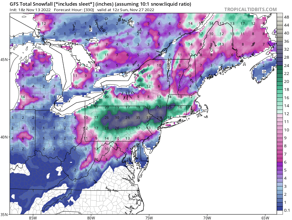
I see your porn map and raise you a weenie map and so it begins.

-
Rob, the first snow map and no snowhole for you
-
-
Your talking about the snowboard I assume
-
27 was the low here.
-
DCA: +4.1 NYC: +3.9 BOS: +3.7 ORD: +4.7 ATL: +3.0 IAH: +3.1 DEN: +2.0 PHX: +1.0 SEA: +0.3
-
I agree with you especially at the lower elevations. I believe you’re correct with the influence. keep on running with the tradition, it’s been working well so far
-
Interesting, I’m about 80% still on the trees. The last 2 days have dropped most of the 20%. I see that the the low at MGJ was 31 where SWF was 39. That would show the difference in the leaf difference with the temps mostly cooler on average your way. A couple of cool nights coming up with around or just under 32.
-
A great time to say goodbye to that ball. If your luck is the same as mine, you won’t find your ball but will come out finding 2 more.
-
Great write up, thanks for your time and efforts.
-
0.35 in the so far today. Light rain currently. Edit, 0.46 is the total for both events today.
-
1.01
-
34 here for the low.