hudsonvalley21
-
Posts
4,248 -
Joined
-
Last visited
Content Type
Profiles
Blogs
Forums
American Weather
Media Demo
Store
Gallery
Everything posted by hudsonvalley21
-
You never know. Even a broken clock is right twice a day.
-

-
A lot of time to see the trends. Hopefully they are bumps east not west.
-
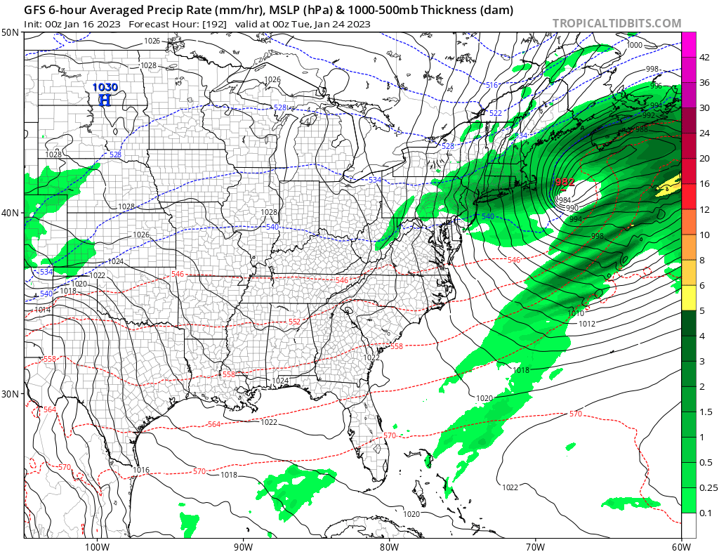
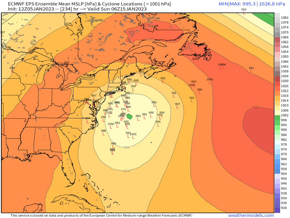
Looks like the 12z GFS run has next weeks systems shifting further east from the 06z run. Subject to change of course.
-
-
If we do get a snowy weather event this winter , maybe the mods can add it back for a celebration.
-
Ok how bout a GFS for 1 run.
-

-
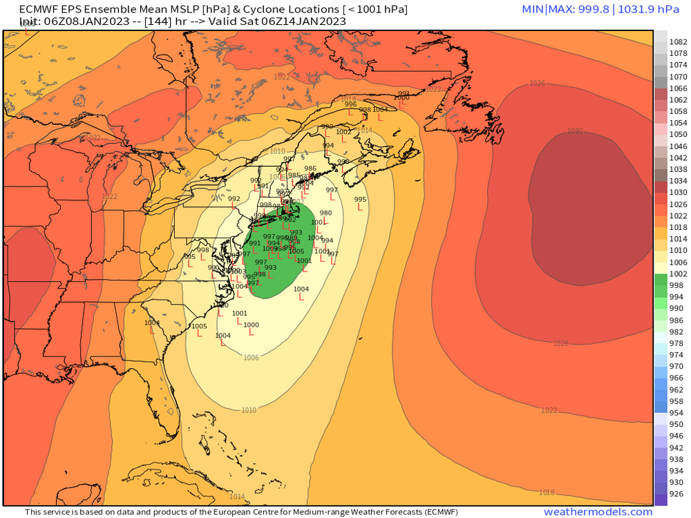
Today’s 12z runs are more favorable for the 19-20th event,(still waiting on the Euro run). We’ll see if they start keeping with continuity for the next couple of days.
-
No thunder here too. Temps up to 48. Up 7 in the last hour.
-
Oh now I see it.

-
Warm front pushing thru. Up 6 degrees in the last hour. Up to 47.
-
Thunder by you now? Special Weather Statement National Weather Service New York NY 631 PM EST Thu Jan 12 2023 NJZ002-NYZ067>069-130000- Western Passaic NJ-Putnam NY-Rockland NY-Orange NY- 631 PM EST Thu Jan 12 2023 ...A strong thunderstorm will impact portions of central Passaic, Orange, western Putnam and Rockland Counties through 700 PM EST... At 630 PM EST, Doppler radar was tracking an area of strong thunderstorms centered over Warwick, moving northeast at 40 mph. HAZARD...Winds in excess of 30 mph. SOURCE...Radar indicated. IMPACT...Gusty winds could knock down tree limbs and blow around unsecured objects. Locations impacted include... Newburgh, Middletown, Ringwood, Monroe, Walden, West Point, Warwick, Goshen, Sloatsburg, Cold Spring, New Windsor, Gardnertown, Chester, Montgomery and Greenwood Lake.
-
Sleet shower here this morning that flipped over to rain. No accumulation.
-
Let me bring one down and I’ll ask it.

-
I got the t-shirt

-
-
Only fun so far is writing the check for the heat bill. I did get to fire up the snow blower when I changed the oil in it a month ago. A chance of light snow tomorrow night into Monday morning. Maybe some mood flakes.
-
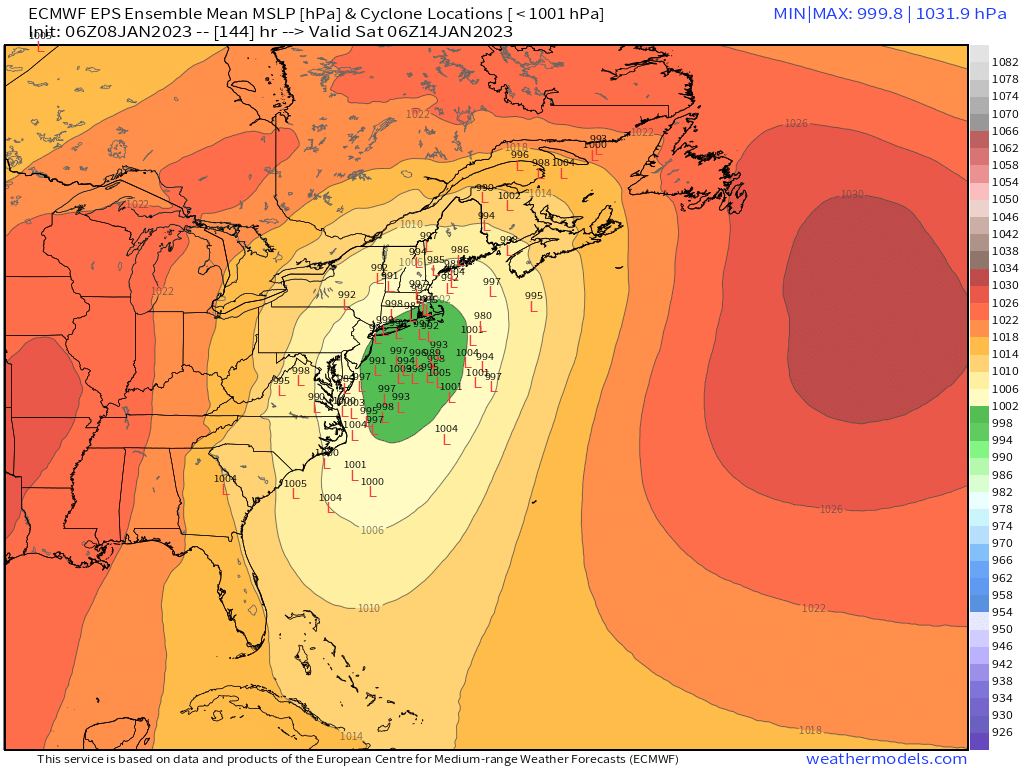
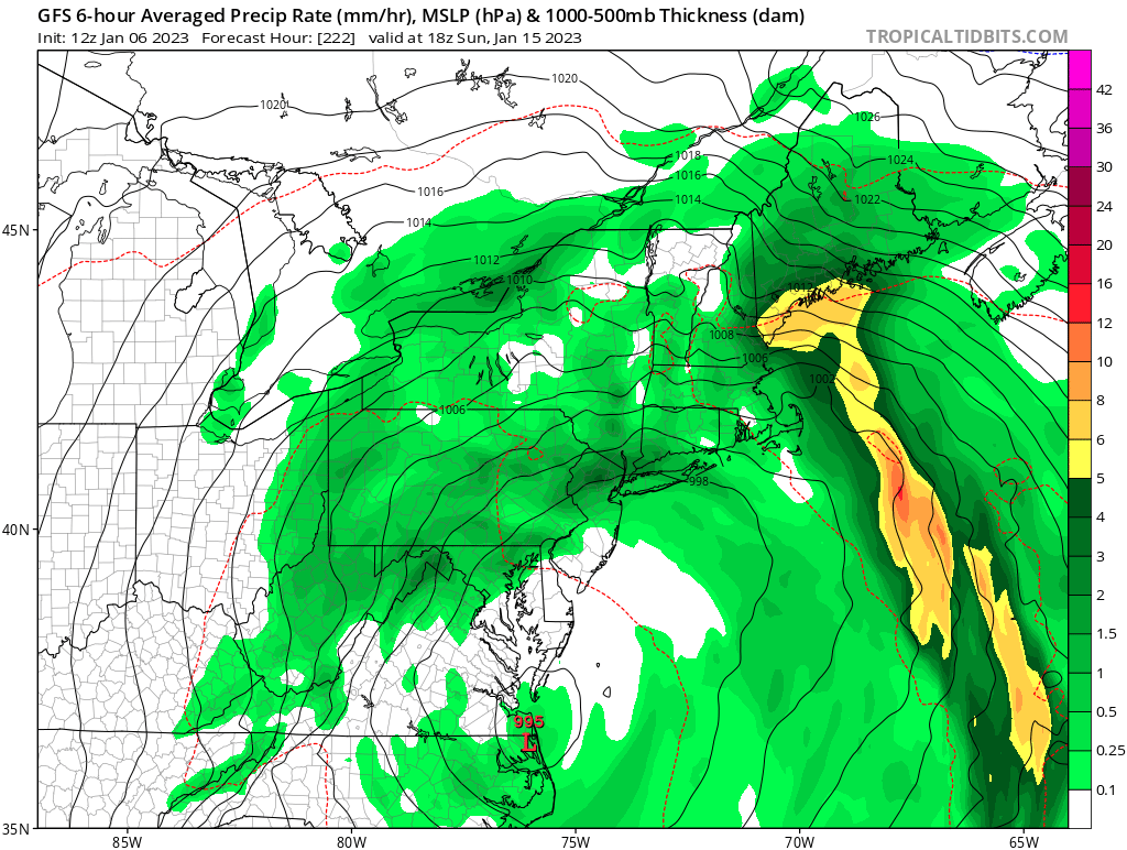
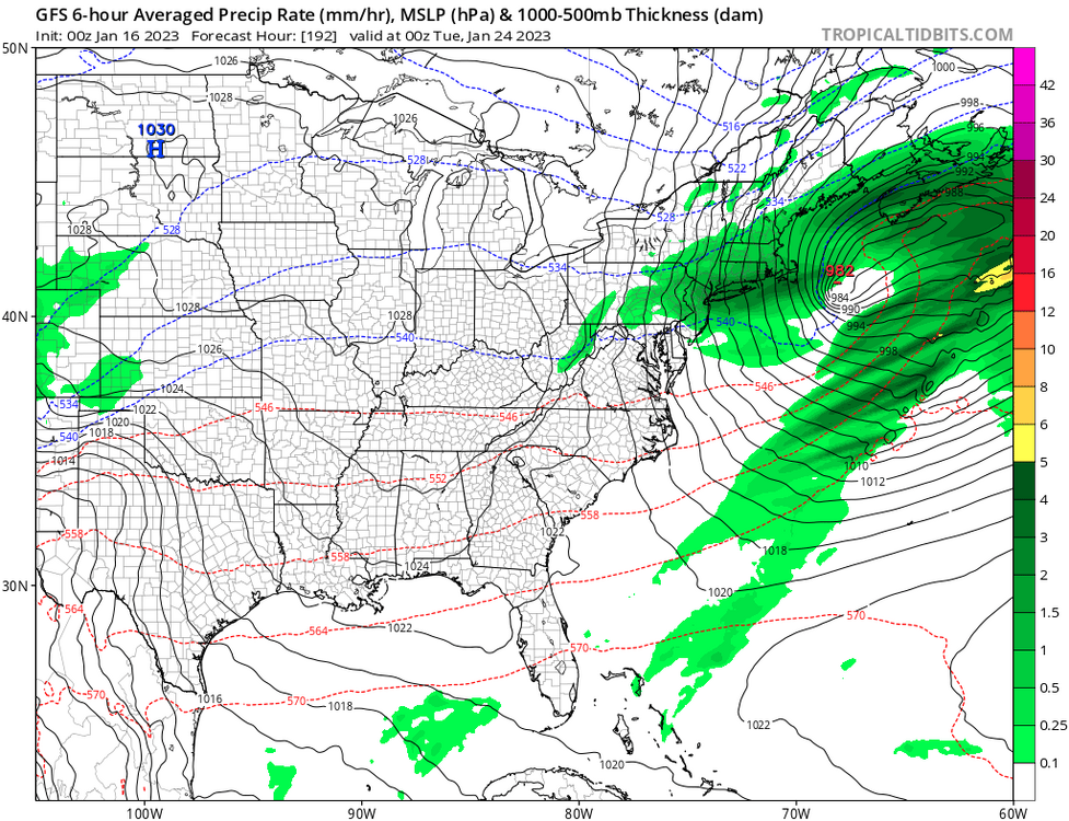
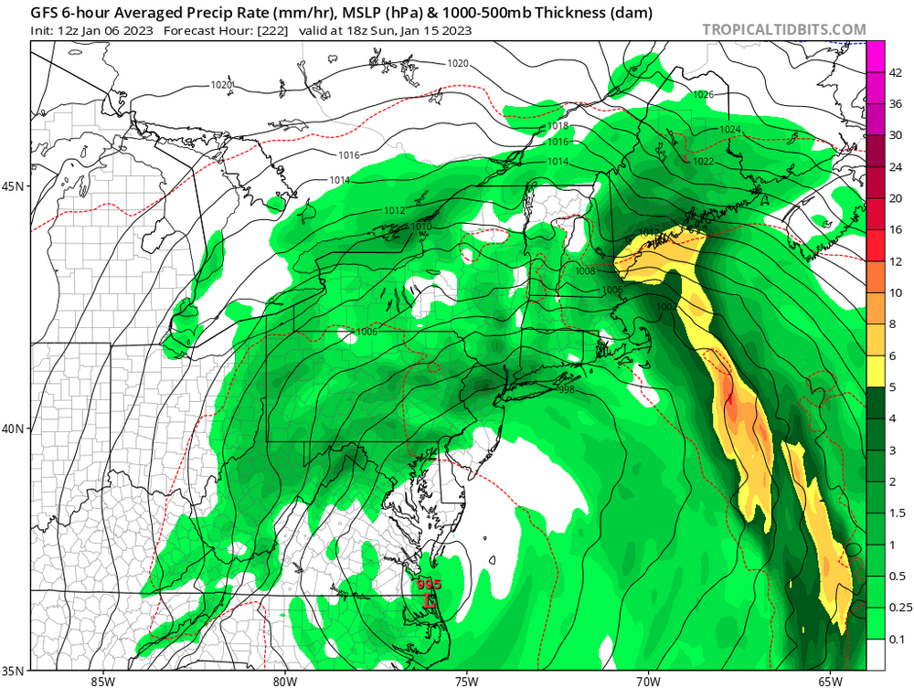
A slow mover. We’ll see how things unfold.
-
000 NOUS42 KNHC 051858 REPRPD WEATHER RECONNAISSANCE FLIGHTS CARCAH, NATIONAL HURRICANE CENTER, MIAMI, FL. 0200 PM EST THU 05 JANUARY 2023 SUBJECT: WINTER SEASON PLAN OF THE DAY (WSPOD) VALID 06/1100Z TO 07/1100Z JANUARY 2023 WSPOD NUMBER.....22-036 AMENDMENT I. ATLANTIC REQUIREMENTS 1. NEGATIVE RECONNAISSANCE REQUIREMENTS. 2. OUTLOOK FOR SUCCEEDING DAY.....NEGATIVE. II. PACIFIC REQUIREMENTS 1. FLIGHT ONE - TEAL 72 A. 07/0000Z B. AFXXX 05WSE IOP07 C. 06/1645Z D. 25 DROPS APPROXIMATELY 60 NM APART WITHIN AN AREA BOUNDED BY: 25.0N 125.0W, 25.0N 145.0W, 45.0N 145.0W, AND 45.0N 125.0W E. AS HIGH AS POSSIBLE/ 06/2030Z TO 07/0230Z 2. FLIGHT TWO - NOAA 49 A. 07/0000Z B. NOAA9 06WSC IOP07 C. 06/1945Z.....(CHANGED) D. 30 DROPS APPROXIMATELY 60 NM APART WITHIN AN AREA BOUNDED BY: 25.0N 140.0W, 25.0N 160.0W, 45.0N 160.0W, AND 45.0N 140.0W E. 41,000 TO 45,000 FT/ 06/2330Z TO 07/0230Z 3. SUCCEEDING DAY OUTLOOK: A USAF RESERVE WC-130J AIRCRAFT AND THE NOAA G-IV AIRCRAFT MAY FLY TWO CONCURRENT ATMOSPHERIC RIVERS MISSIONS OVER THE CENTRAL AND EASTERN PACIFIC FOR THE 08/0000Z SYNOPTIC TIME. 4. ADDITIONAL DAY OUTLOOK: A USAF RESERVE WC-130J AIRCRAFT AND THE NOAA G-IV AIRCRAFT MAY FLY ANOTHER TWO CONCURRENT ATMOSPHERIC RIVERS MISSIONS OVER THE CENTRAL AND EASTERN PACIFIC FOR THE 09/0000Z SYNOPTIC TIME. $$ SEF NNNN
-
We’ll see. There is a flight scheduled today I believe to analyze the pacific activity. So there will some information inputted into the models. Maybe day or two of updates instead of waiting for theses systems to come onto the west coast.
-

-