

FallsLake
-
Posts
6,317 -
Joined
-
Last visited
Content Type
Profiles
Blogs
Forums
American Weather
Media Demo
Store
Gallery
Everything posted by FallsLake
-
Day 9/10 may be another shot before the warm up. You're right, the above look would keep the low more suppressed or at least have a CAD (Miller B).
-
Something else that is of interest to me is if we can end January below normal. In years past I've seen the SE CAD areas be able to stay closer to normal as a large area of the US torch. Instead of blazing SW or west winds, numerous CADs develop keeping this zone closer to normal. Nothing cold enough for frozen but cooler never the less. Below is the first example (NAM) for this upcoming Monday. looking at the GFS it would have 3 or 4 weak CAD events through the LR.
-
With no negative EPO the January Thaw has to be given a higher chance of verifying (as depicted). PNA and NAO look bad in the LR as well. But the next timeframe (week 5 to 6) may be our next and maybe our last real chance to score a big SE winter storm. Hopefully as we get closer the EPO will stay negative longer. we've seen this happen in the past.
-
But this air mass will already be in place. I think the big questions are, how fast does the precip come in and (as Grit said) can a meso high develop to our north. Big pieces to the puzzle.
-
It's hard living in this area. We're just cold enough to have a shot at most east coast winter storms, but end up falling short most times. We have a another potential shot at getting something (ice) Monday. Again, the cosmos has to be in line. But because we have a shot, we'll track each model run.
-
12z NAM dew points at hour 84. Hard to dismiss the possibility of a strong in-situ damming event.
-
That would be great. I still think we go through some sort of relaxation. No science to why, but basically because we normally do from a historical perspective.
-
GFS says the January thaw starts at mid month. Looking at the indices, the PNA looks to stay positive(good), AO has a huge spread but I guess it averages negative (??good), NAO does what it always does and stays positive (bad), but the biggest difference is the EPO looks to go positive (bad). We've seen winters where the LR models show warmth just to get the warmth knocked back as we get closer. But I would say a thaw/relaxation should be expected. The question then is how long does it last. 6z GFS day 16 2m anomalies:
-
Terrible for my location. That band has dissipated coming out of Durham and I think northern Wake may get the shaft on this. Will probably get some accumulations but not very much. I guess I shouldn't be complaining, but it's going to hurt see the snow map with higher numbers to my west and east. Oh well done venting...
-
Pack it's on your door step. RAH thinks you may be in one of the sweat spots with 2-3"
-
I remember a few years back we saw the models keep showing warm ups in the LR, but the EPO totally dominated the pattern and it kept us cold. The models would just keep pushing the warm up back. **Ironically opposite of what we're use to where the models keep pushing our cold back.
-
6z GFS sets up a typical la Nina pattern after the first week of January. Looks like cold shots, warm up with lake cutters, and then cold again. This is where we really need the help of the NAO.
-
The mountains are definitely our enemy with clippers. For our area (Central / eastern NC), we tend to do better than folks to the south and west of us. Two reasons: 1) Biggest reason is the trajectory of the precipitation over elevated areas to our NW. **draw a line from RDU NW and the elevation of areas through VA and WV are mostly in the 3000 - 4000 range. Draw a line from Charlotte down to Greenville SC NW and you have 5000 - 6000 foot mountains. Basically they have more of a rain (snow) shadow effect. 2) Also for clippers it's just better to be farther north and east because of the traversal of the wave as it goes from NW to SE.
-
looking at the indices and it would signal a continuation of our current pattern: PNA - Looks to stay positive throughout the LR. Maybe flirting with neutral towards the end. AO - Looks to be predominantly negative in the LR, ensuring cross polar air into NA NAO - Positive, which is now normal for us. **this is hurting our chances of a storm ridding up the coast. EPO - Looks to stay negative LR models (going out 12 days) also indicating a colder than normal LR. But it looks dry. The 6z GFS shows very little precip over the SE. So it looks like our Mongolian cold and dry winter continues.
-
As I said before, in this pattern of suppression we may have to pin our hopes on a clipper. Usually clippers stay just a little too far north for many on this board but with these massive highs and deep troughs we can now score. The last two runs of the GFS show something at ~ day 9. It's definitely too far out to get excited about but I believe this more that a big storm showing 5 days out. 6z GFS (similar to the 0z):
-
Yeah, I'm disappointed. Just looked at the Euro and it's just cold and dry for RDU for the next 10 days. We may get some kind of clipper (..never modeled well) give us something but the big storm signal has slipped away. Way out at 10 days it has some kind of system, but that's fantasy range. For folks in the deep south, this might be a good pattern for you. Any waves that do pass to the south could give you some rare wintery preicp.
-
The December to Remember 7th-8th blue turd winter threat thread.
FallsLake replied to lilj4425's topic in Southeastern States
Mostly sleet again, some flakes mixing in (34.1). After looking at the latest RAP, this might be what I get for the majority of the event. Lots of frames where I'm in the "purple". -
The December to Remember 7th-8th blue turd winter threat thread.
FallsLake replied to lilj4425's topic in Southeastern States
The latest RAP is ever so colder for areas to the east. RDU is going to be on the line for some of the heaver amounts (...or should I say rates). -
The December to Remember 7th-8th blue turd winter threat thread.
FallsLake replied to lilj4425's topic in Southeastern States
0z NAM hour 21: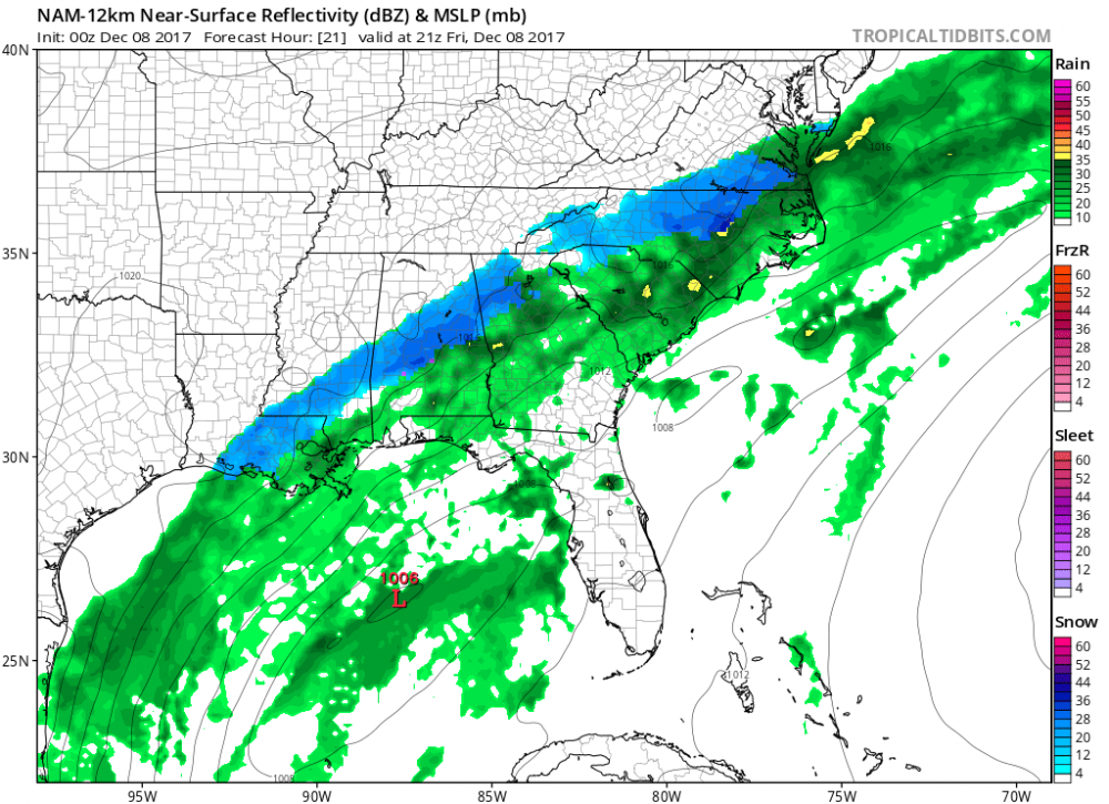
-
The December to Remember 7th-8th blue turd winter threat thread.
FallsLake replied to lilj4425's topic in Southeastern States
Oz NAM better for RDU. Looks like it will flip between snow and rain with heaver rates. -
The December to Remember 7th-8th blue turd winter threat thread.
FallsLake replied to lilj4425's topic in Southeastern States
Dealing with the last couple of runs of the HRRR, it backed off on the intensity of precip which then backed off on the cooling. The latest 0z increase precip rates some which then also increases mixing; particularly around RDU. So basically if you want snow, you need heavy precip to occur. -
The December to Remember 7th-8th blue turd winter threat thread.
FallsLake replied to lilj4425's topic in Southeastern States
Latest RAP(20z) is out and it continues to show RDU getting hit hard. Hour 19 to correspond to the past post with hour 20: -
The December to Remember 7th-8th blue turd winter threat thread.
FallsLake replied to lilj4425's topic in Southeastern States
Here's the latest RAP at hour 20: -
The December to Remember 7th-8th blue turd winter threat thread.
FallsLake replied to lilj4425's topic in Southeastern States
I'm really pulling for the HRRR. It along with the RAP look better for our area: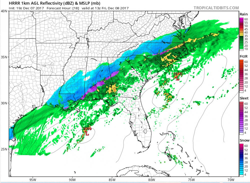
-
The December to Remember 7th-8th blue turd winter threat thread.
FallsLake replied to lilj4425's topic in Southeastern States
For us RDU folks we need to hope that the 3Km NAM has the right idea about snow on the back end:


