FallsLake
-
Posts
6,318 -
Joined
-
Last visited
Content Type
Profiles
Blogs
Forums
American Weather
Media Demo
Store
Gallery
Everything posted by FallsLake
-
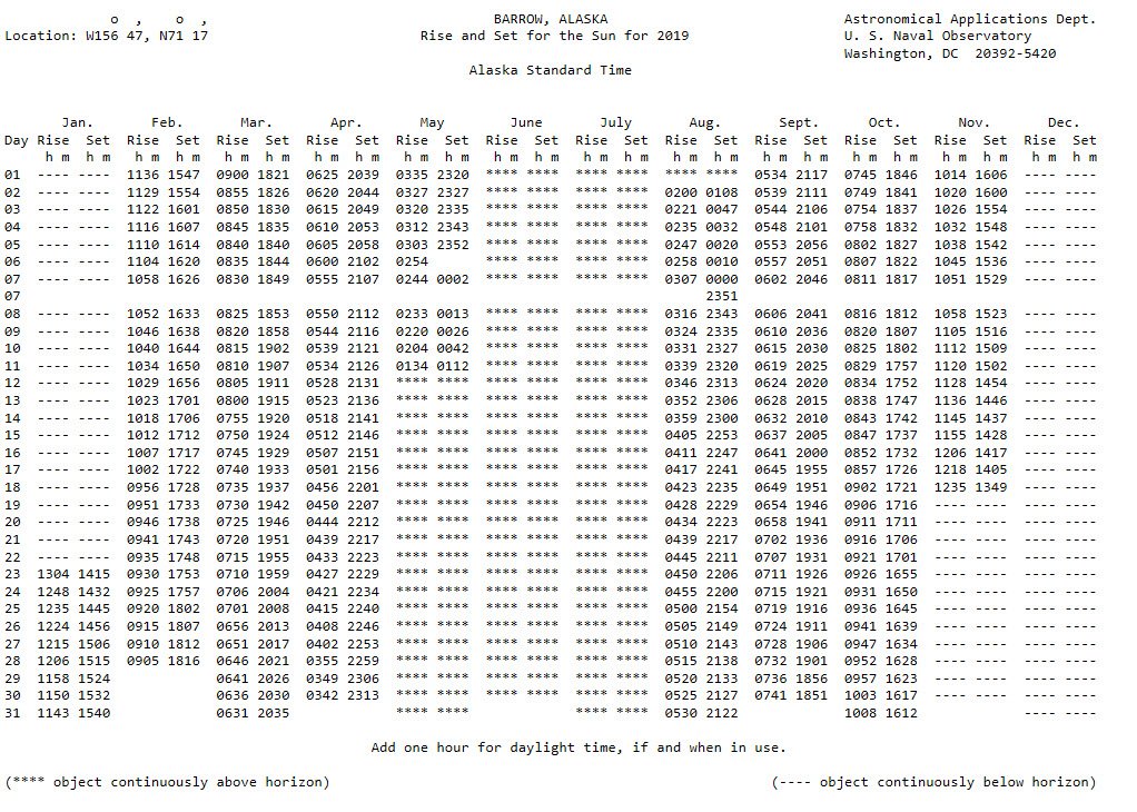
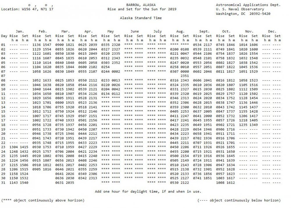
Here's something small to celebrate; the sun sets at Barrow Alaska tonight (first time since spring).
-
Yeah even though it's very rare, it's something we can hope to see again in the future.
-
Thanks for the great response!! I'm actually coping this post for future reference. Your probably right about the underlying reason for the article. And we very well could be f*!&ed. But (if we want to very selfish and shortsighted), if the arctic is going to hell we might as well score some good winter storms.
-
I'm definitely with you on truly wanting/wishing that the ice lose would reverse course; which it looks like it will not anytime soon. But saying that, what do you think of the concept that as the Arctic warms, lower latitudes could cool (especially in winter). https://news.nationalgeographic.com/2017/07/global-warming-arctic-colder-winters-climate-change-spd/ ** I suppose this could also go along with the idea that the Gulf stream could slow or stop...
-
Here's a good discussion (..at the end it turns to a debate) on lake effect snows for central and eastern NC. There are some good example links for 2003 and 2009. https://cimmse.wordpress.com/2014/02/05/an-examination-of-lake-enhanced-snow-across-central-nc-on-22-january-2014-2/ As a side note: While living in Wake Forest back in the 90s, we had a similar event whereas a cold front passed and a nearly stationary thin band of snow formed over northern Wake County. Ended up with ~1" of snow (nothing was forecasted).
-
Had a great storm a couple hours back. Got right at 2". Really needed it.
-
Here's a good link of weather hazards from NOAA (...quick catch all): https://noaa.maps.arcgis.com/apps/MapSeries/index.html?appid=cf93575e5535467199da7358ee6c825c
-
Happy Summer Solstice everybody! Good news: The length of daylight will now start to shorten with each passing day. Bad news: It will continue to warm for about another month. **we have to reach equilibrium.
-
You'll eventually get some rain if the models are even half right.
-
Finally!!! 1.02" at the house. Had a heavy downpour with some nice wind gust. The monkey is off the back...
-
Don't want the severe weather, but would love to see the better rain coverage folks to our SW are currently getting.
-
Bad for the hail, great for the rain. I feel lucky to have the .09" from the first band. Really hoping for a little more with the second band.
-
Yeah, that Greensboro to Roxboro zone seems to always be in the action. **center of the CAD.
-
Get a window unit. Put it in your bedroom window so you can at least be cool while you sleep. And it's always good to have a backup system in case (when) your new central air has problems in the future.
-
Nice! Going from reading about others getting snow to being one of the snowiest on the board.
-
For the Triangle you're in a good spot. The Wake County split has been in full affect the last three years. I've done good at my location whereas folks south and east of Raleigh have missed out on most of the storms. You would have to think the luck will change soon and NC get a big coastal plain special; but who knows...
-
There's always a chance a big storm could hit, but statistically not likely. Many (many) years back I took a trip with my parents to Colorado. It was early September and it was great; right before all the trees started changing colors and the cold took over. Drove up to Pikes Peak and traveled through the high elevation areas west of Colorado Springs (..Cripple Creek area). Later in life my wife and I camped in the Rocky Mountains National Park; but funny that was in July and we had a great time then as well. So basically I wouldn't worry about the weather. I would go when it best fits your time and budget.
-
That's great! It's going to be nice to get you back to the area; and to have you as a RDU person. You know this area well, we can score big and bust big.
-
The one good thing about the predominant trough in the west, is the fact that they're getting lots of snow across most of the western states mountain ranges (^^as you guys are stating). This is where the western folks get most of their yearly water supply. So in short, look for good deals this upcoming year on vegetables, fruits, and nuts. **bad side is there could be a larger burn season coming up this fall with all the spring growth.
-
Yeah, we have one more opportunity for things to swing better (+PNA) by the end of the month. But I'm with you, the odds are not good at this point.
-
Many years back my Dad was stationed there. From his stories, you will see snow and cold.
-
Most definitely. I'm almost expecting to see the 7/8 day disappear and another day 10/11 show up; keeping us hooked. But at least we have a little bit of hope.
-
Lol..lets hope. I am keeping an eye on the day 7/8 time period. Maybe we can get something wintery.
-
Well that's it, Punxsutawney Phil just said it's going to be an early spring.
-
If it's right spring is here. Doesn't get bellow freezing in the SE through mid month, and it wouldn't look good afterwards. FV3 is better. It still has the day 8/9 storm. Lets hope it is right.