Sydney Claridge
-
Posts
532 -
Joined
-
Last visited
Content Type
Profiles
Blogs
Forums
American Weather
Media Demo
Store
Gallery
Everything posted by Sydney Claridge
-
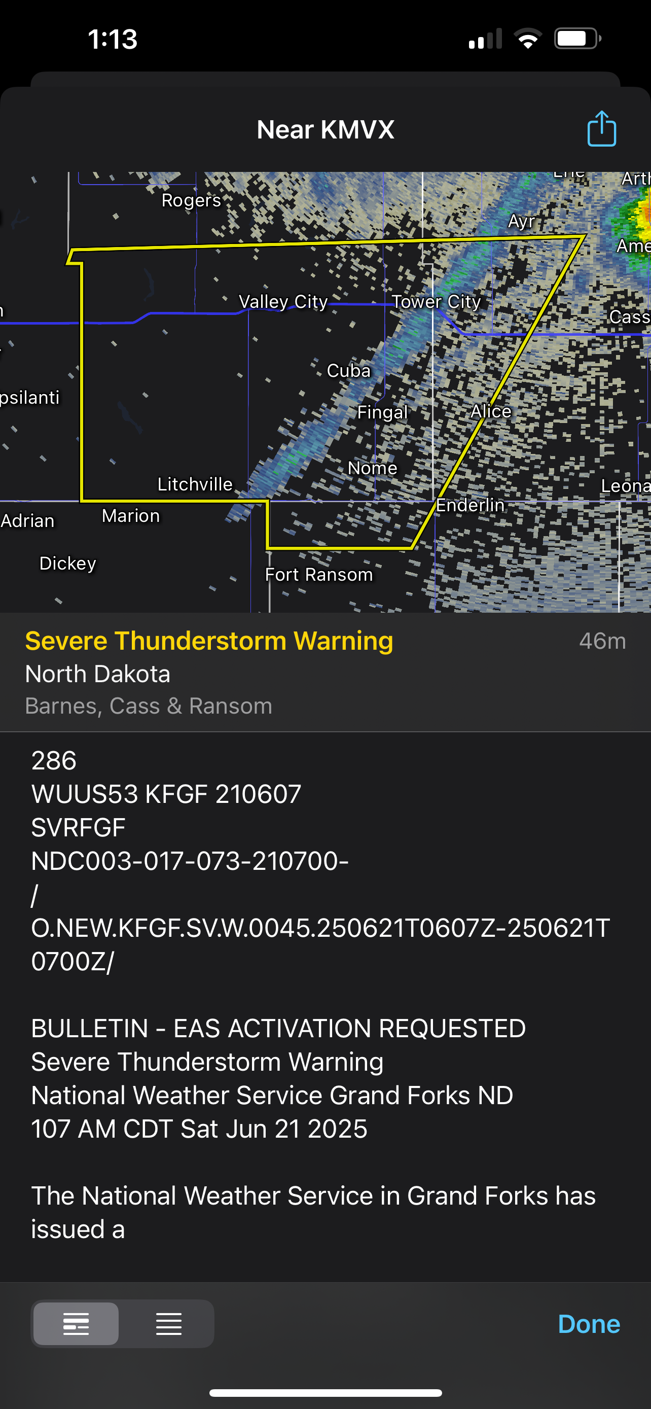
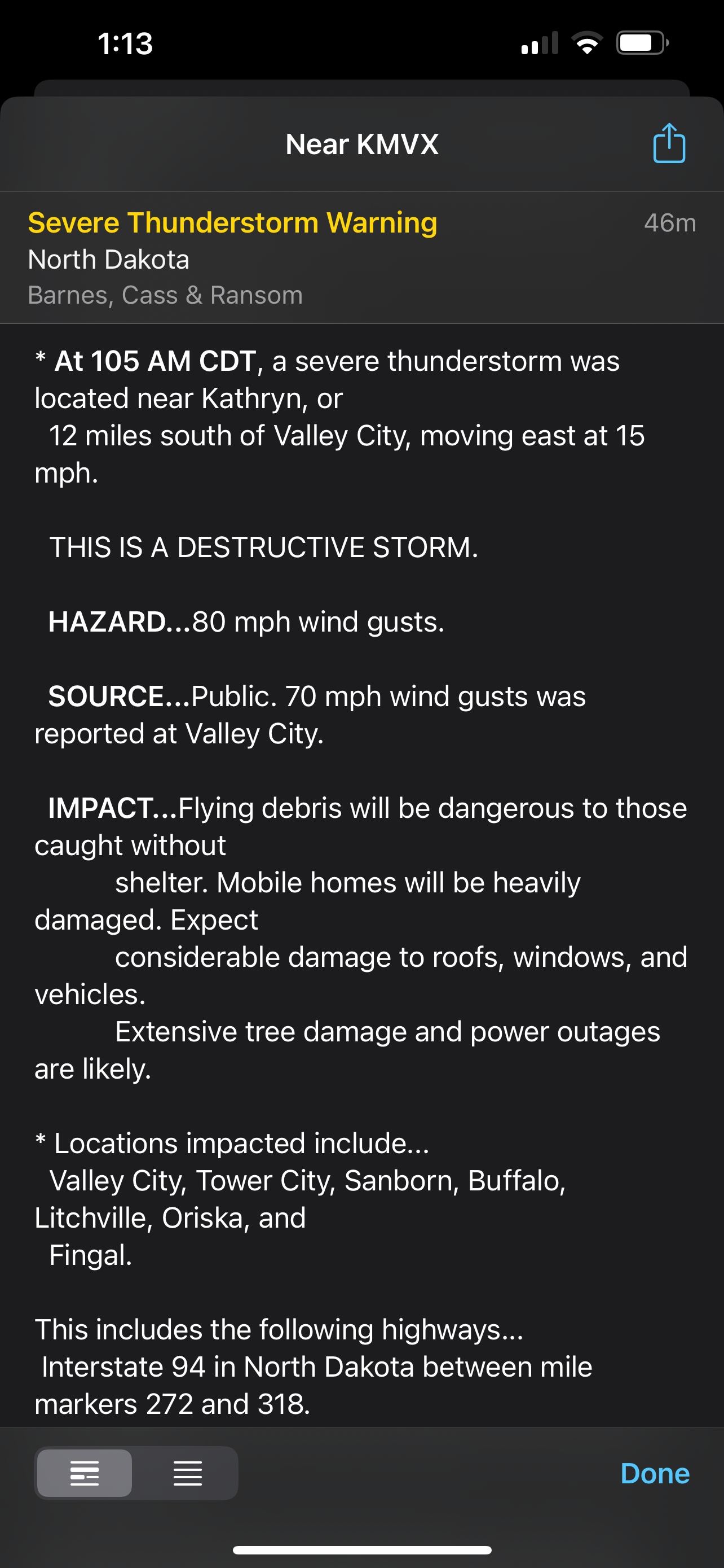
Even this gust front got a severe thunderstorm warning with a “destructive” tag. It’s incredible how much wind energy there is.
-
Rotation seems to be tightening near/over Kimball, MN.
-

4/2-4/3 Potential Major Severe WX Outbreak
Sydney Claridge replied to Geoboy645's topic in Lakes/Ohio Valley
Tornado crossing I-55 in Cape Girardeau, MO with power flashes, per KFVS livestream. -
4/2-4/3 Potential Major Severe WX Outbreak
Sydney Claridge replied to Geoboy645's topic in Lakes/Ohio Valley
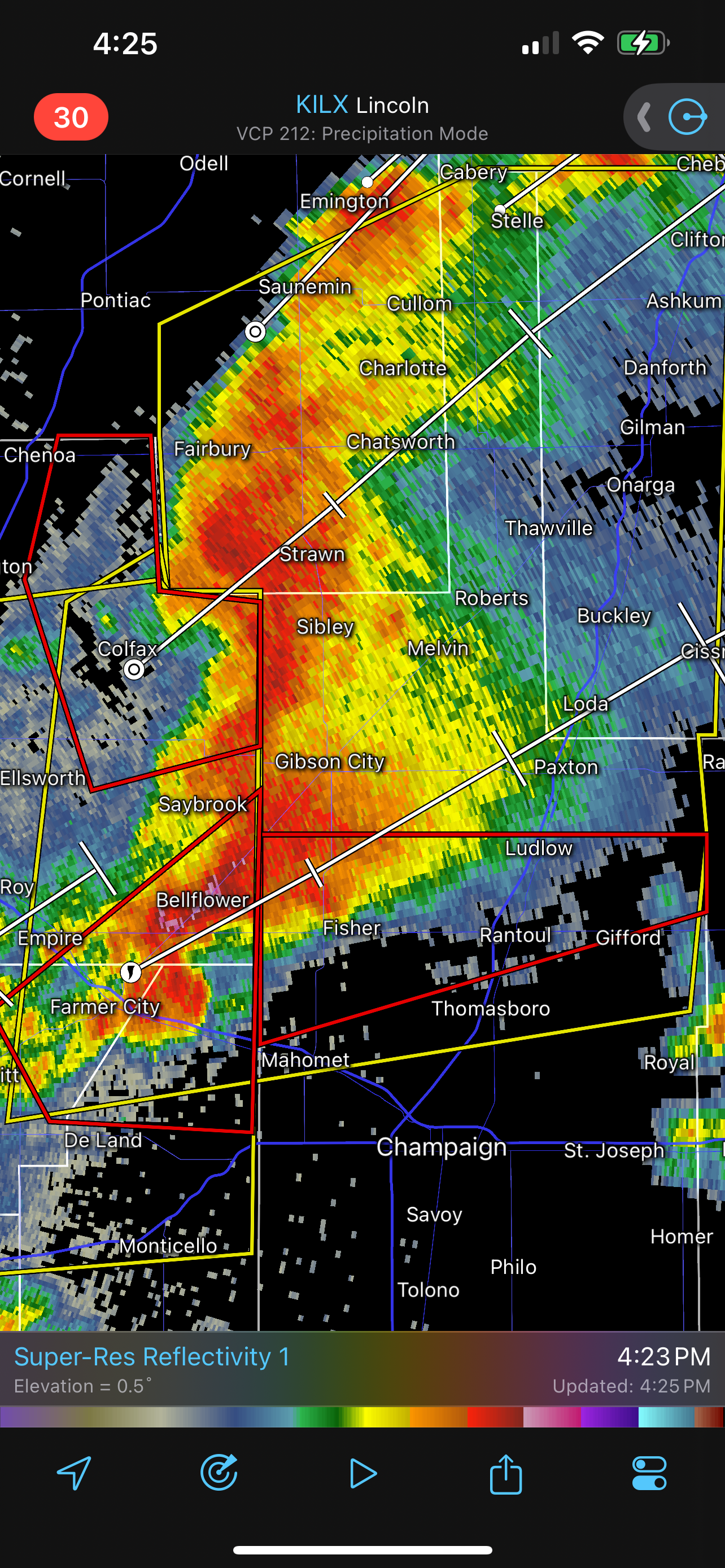
The county to the north probably needs a tornado warning on it. The rotation looks to be passing more towards Paxton, IL and north of Rantoul (the county line there is the boundary between the NWS offices in ILX and LOT). -
4/2-4/3 Potential Major Severe WX Outbreak
Sydney Claridge replied to Geoboy645's topic in Lakes/Ohio Valley
This storm east of Farmer City, IL moving towards Rantoul looks a little concerning, especially if the rotation tries to tighten up any more.
-
March 14-15 Severe Weather Outbreak
Sydney Claridge replied to HillsdaleMIWeather's topic in Lakes/Ohio Valley
I'm getting very concerned about this tornadic storm as it moves closer into the STL metro. A PDS warning was definitely warranted for it. -
March 14-15 Severe Weather Outbreak
Sydney Claridge replied to HillsdaleMIWeather's topic in Lakes/Ohio Valley
I feel like there are questions on moisture return at the moment as to why SPC didn’t go PDS. -
Texas 2024 Discussion/Observations
Sydney Claridge replied to Stx_Thunder's topic in Central/Western States
70/40 tornado probabilities too. The watch does cover a large area (DFW all the way up to the OK/KS border), though. -
Texas 2024 Discussion/Observations
Sydney Claridge replied to Stx_Thunder's topic in Central/Western States
I'm definitely keeping an eye on that area of showers currently over the DFW area (and more generally along and west of the I-35 corridor in north Texas), to see if any supercells try to go up within the next few hours. -
2024 Short/Medium Range Severe Weather Discussion
Sydney Claridge replied to Chicago Storm's topic in Lakes/Ohio Valley

-
May 16 - June 4, 2024 Severe Weather
Sydney Claridge replied to Quincy's topic in Central/Western States
If that tornado was on the ground that entire time, I suspect it would be one of the longest tornado tracks on record (if not the longest track) for the areas near/around DFW. While we are at the southern end of Tornado Alley, north-central Texas has actually had very few long-track (25+ miles) tornadoes in its record. -
Texas 2024 Discussion/Observations
Sydney Claridge replied to Stx_Thunder's topic in Central/Western States
There's definitely a significant temperature/moisture boundary (warm front?) over DFW right now. Upper 70s and 80s with 70s dewpoints to the south of DFW at the moment, with 60s and low 70s with dewpoints in the 40s north of DFW. While hail and wind will be the biggest threat, I also want to be mindful of any possibilities for tornadoes when such a boundary is in place, as there is often localized enhancement of tornado parameters near/along these sort of boundaries. -
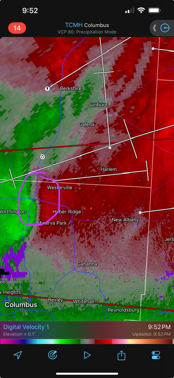
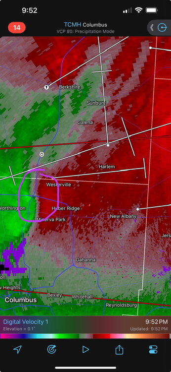
This area needs to be watched very closely as it moves into Westerville and New Albany.
-
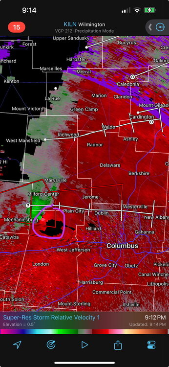
Not going to rule anything out, but it looks like that storm moving into Cincinnati seems to be getting cut off by outflow. There may be some spin-up potential around Lebanon, OH as well. There's also the storm moving towards the northern Columbus suburbs. Places like Plain City and Dublin will soon be in its path, and perhaps Westerville and New Albany down the line. On the other hand, SPC Mesoanalysis is showing a sudden drop-off in tornado ingredients around the Columbus metro, but I wouldn't count on the storm weakening before it impacts the Columbus metro, either. This storm is well-isolated from other storms, so there is definitely potential for concern. EDIT: rotation tightening between Mechanicsburg and Plain City.
-
Those training supercells lined up southeast of Indianapolis are reminding me of the storms that trained north of Oklahoma City yesterday, had those storms in Oklahoma not become outflow-dominant (of course the OK storms had a higher parameter space had they not become outflow-dominant, but still…).
-
Severe Weather 5-6 through 5-9-24
Sydney Claridge replied to cheese007's topic in Central/Western States
It just escalated. Severe thunderstorm warning with a destructive damage threat tag now out for the Moore area, with 80 MPH wind gusts possible. -
Severe Weather 5-6 through 5-9-24
Sydney Claridge replied to cheese007's topic in Central/Western States
Me too. There's nothing too concerning on that storm around Gracemont and Binger just yet, but it wouldn't take much at all for that to change. -
Severe Weather 5-6 through 5-9-24
Sydney Claridge replied to cheese007's topic in Central/Western States
The debris ball has even stronger reflectivity now. My heart just sank upon seeing this.
-
Severe Weather 5-6 through 5-9-24
Sydney Claridge replied to cheese007's topic in Central/Western States
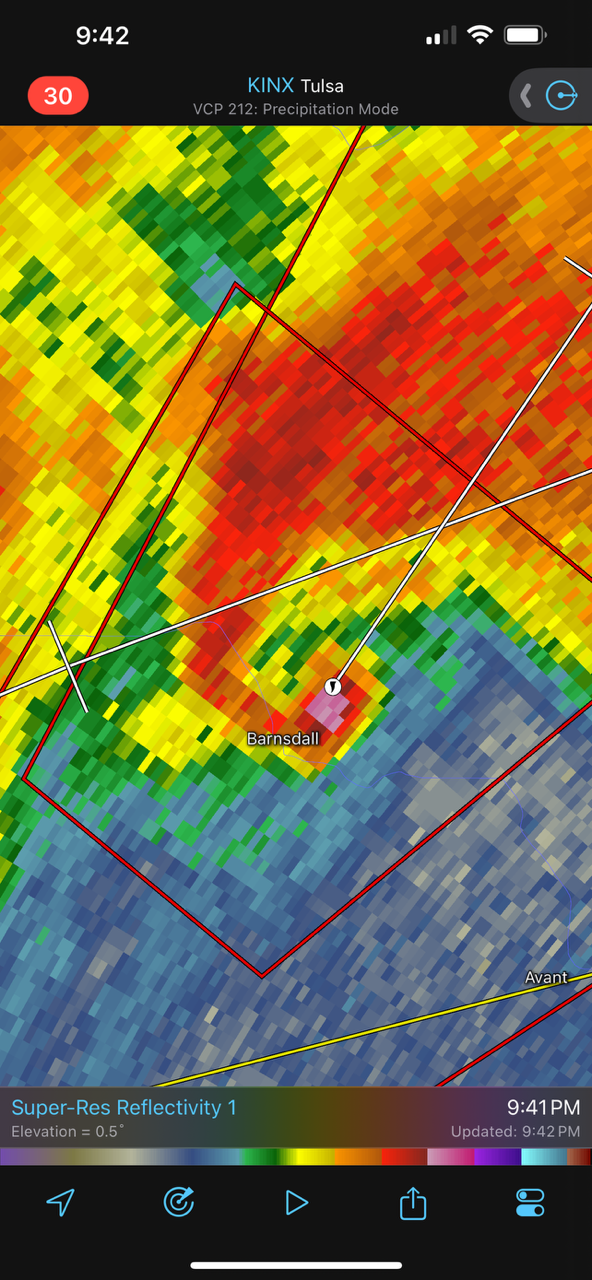
The storm approaching Barnsdall, if it holds together, is on a track that would take it into (or at least close to) Bartlesville in around 30 minutes. Hopefully that line to the west will catch up to this supercell soon. -
Severe Weather 5-6 through 5-9-24
Sydney Claridge replied to cheese007's topic in Central/Western States
Thank goodness, because the other ingredients in place would allow for strong tornado activity if a supercell went up. -
Severe Weather 5-6 through 5-9-24
Sydney Claridge replied to cheese007's topic in Central/Western States
I don't think I've ever seen a VTP as high as 20 before. The ingredients in place over central and northern Oklahoma are absolutely insane. -
Severe Weather 5-6 through 5-9-24
Sydney Claridge replied to cheese007's topic in Central/Western States
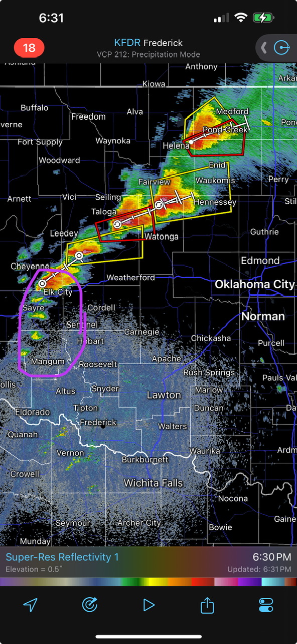
Looks like there are now attempts at initiation south of I-40 now. This needs to be watched very closely, especially down the line as the storms near the OKC metro.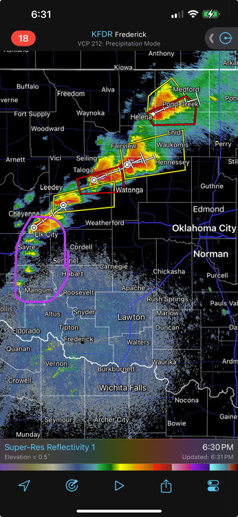
-
Severe Weather 5-6 through 5-9-24
Sydney Claridge replied to cheese007's topic in Central/Western States
It's definitely too early to call this a bust. Let's not forget what happened in southern Oklahoma on April 27th; that outbreak didn't really get underway until after dark. The deeper, richer moisture is further east, and the News 9 livestream just mentioned this. -
Severe Weather 5-6 through 5-9-24
Sydney Claridge replied to cheese007's topic in Central/Western States
That would be good news for the OKC metro if this remains the case. That's a big if, and I'm not counting on this remaining the case. -
Severe Weather 5-6 through 5-9-24
Sydney Claridge replied to cheese007's topic in Central/Western States
The area between I-70 in Kansas and I-40 in Oklahoma has really lit up with supercells now. It's only a matter of time before we start seeing this tornado outbreak begin in earnest. We have two tornado-warned cells in northwest Oklahoma now, one by Waynoka and now the cell east of Mutual.