Sydney Claridge
-
Posts
532 -
Joined
-
Last visited
Content Type
Profiles
Blogs
Forums
American Weather
Media Demo
Store
Gallery
Everything posted by Sydney Claridge
-

Severe Weather March 15-19
Sydney Claridge replied to Sydney Claridge's topic in Central/Western States
The area of rotation looks like it is going to go over Albany. This could be very bad. -
Severe Weather March 15-19
Sydney Claridge replied to Sydney Claridge's topic in Central/Western States
While this may seem like open country, the area of strong rotation either passed over or close to a major state prison facility (as I mentioned in a previous post). A well-built prison would probably be able to take a tornado hit well, but outbuildings would be a concern. -
Severe Weather March 15-19
Sydney Claridge replied to Sydney Claridge's topic in Central/Western States
I'm starting to get concerned about the track of the current tornado-warned storm. It will be getting pretty close to (or even go through part of) Abilene if it continues on its present track. EDIT: Abilene is now included in a Tornado Warning. Fortunately it says the tornado is radar-indicated (and not the strong wording seen back at Sterling City), although it is late at night and hard to spot as a result, so this warning still needs to be taken very seriously. EDIT 2: KTXS reports power flashes north of Tye. EDIT 3: Rotation moved near Impact/northernmost Abilene area. Hamby and the state prison facilities to the north (French Robertson and John Middleton Units) are now in the path of this possible tornado. Not a very populated area aside from the prisons. -
Severe Weather March 15-19
Sydney Claridge replied to Sydney Claridge's topic in Central/Western States
Looks like outflow ahead of this storm on the Palo Pinto/Parker county line may be helping keep it in check. Otherwise, the ingredients here would probably be good for more tornadoes.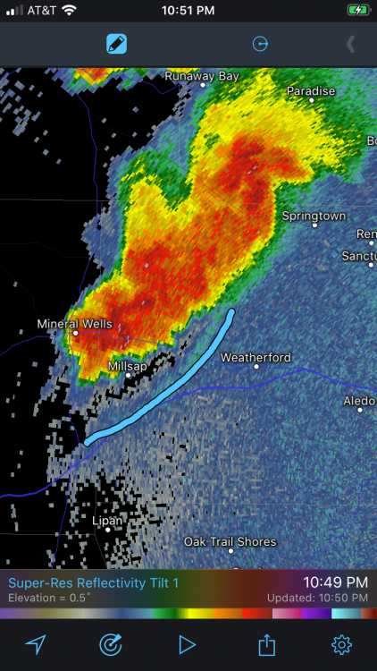
-
Severe Weather March 15-19
Sydney Claridge replied to Sydney Claridge's topic in Central/Western States
Unfortunately those storms west of Mineral Wells are outside of the anvil rain. I am very concerned about intensification as those storms approach the DFW area. Given current storm motions, those storms will impact the Metroplex unless they fall apart first. -
Severe Weather March 15-19
Sydney Claridge replied to Sydney Claridge's topic in Central/Western States
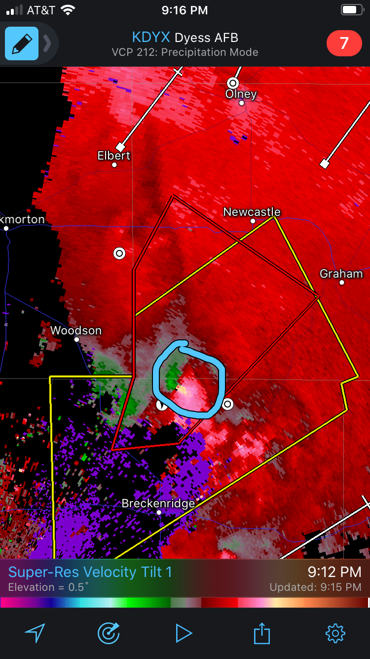
Confirmed tornado north of Breckenridge, near Crystal Falls. Watch that area to the south as well. The area of storms between Breckenridge and Cisco could be trying to develop rotation as well. A right-moving supercell forming there could be a concern for DFW down the line if it holds together.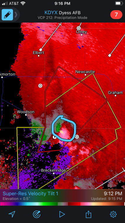
-
Severe Weather March 15-19
Sydney Claridge replied to Sydney Claridge's topic in Central/Western States
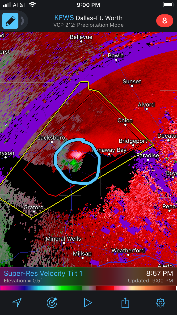
Strong rotation couplet moving east of Jacksboro, near Runaway Bay.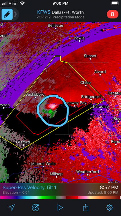
-
Severe Weather March 15-19
Sydney Claridge replied to Sydney Claridge's topic in Central/Western States
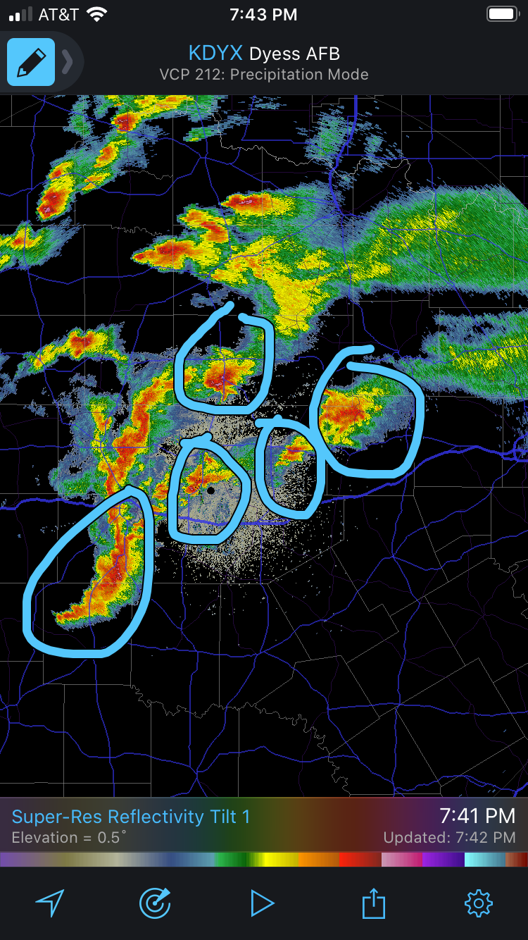
It seems like the expected uptick in helicity is now taking place. We are going to need to watch these highlighted areas (among others) for the possible development of low-level rotation. I also marked the portion of that line south of Abilene given the higher EHI there; this will probably be where any severe thunderstorm threat for the Metroplex would come from later tonight (unless something forms ahead of that).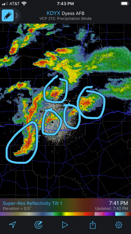
-
Severe Weather March 15-19
Sydney Claridge replied to Sydney Claridge's topic in Central/Western States
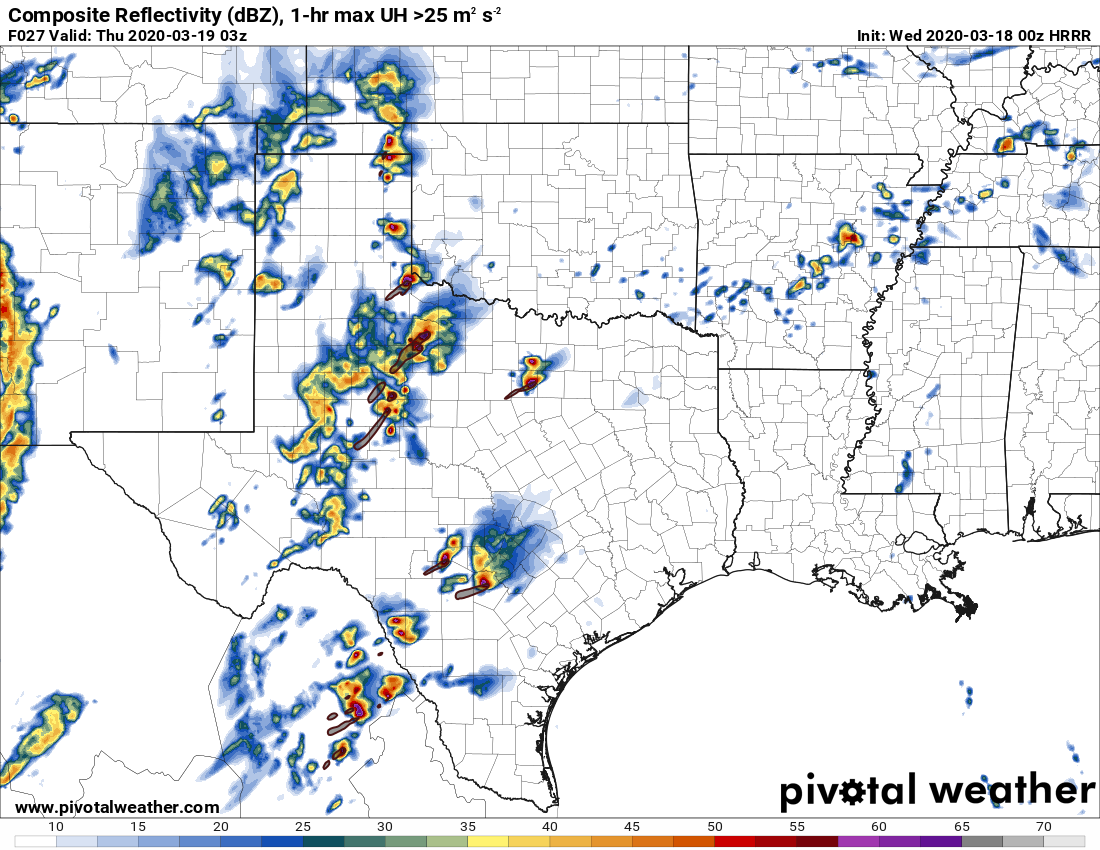
Storm initiation seemed to happen south of where the forecast guidance (HRRR for the forecast reflectivity) on SPC mesoanalysis suggested it would be. This could mean that there is more of a concern for DFW down the line if these cells hold together, considering the HRRR guidance suggested that these initial supercells around Abilene would wind up northwest of DFW. If you extrapolate the forecasted motion from the model then these storms could end up going across the northern DFW metro area. EDIT: I'm watching that supercell SW of Cisco for sure. It has unimpeded inflow and is trying to develop a hook. I am concerned about this storm following the I-20 corridor. -
Severe Weather March 15-19
Sydney Claridge replied to Sydney Claridge's topic in Central/Western States
Last time I recall uncertainty like this was back on October 20, 2019, when we had tornadic supercells form over DFW. That is very much the worst-case scenario though (not in terms of injuries/fatalities but monetary damages), and the effects from that day were more about where the tornado(es) hit, thus the high monetary damages were such due to damage in industrial parks and commercial properties along with affluent residential neighborhoods like Preston Hollow. We don't even know where supercells will try to form until they go up, so I am not saying today's threat will wind up anything like 10/20/19, but in a situation where a supercell goes through the Metroplex with favorable parameters, the potential for a damaging hit is not completely out of the question. -
Severe Weather March 15-19
Sydney Claridge replied to Sydney Claridge's topic in Central/Western States
Fortunately for the DFW area the HRRR runs have shifted the area of evening supercell initiation further west a couple of counties (compared to my earlier posts), so I am little bit less concerned about supercells in the Metroplex. But I'm not going to discount the possibility either, especially with the east edge of the 10% hatched tornado risk in Tarrant and Denton counties. And it seems the sun is trying to come out here in west Fort Worth. I also shifted the date in this thread to better reflect the end of the severe weather threat for this subforum. -
Severe Weather March 15-19
Sydney Claridge replied to Sydney Claridge's topic in Central/Western States
I'm currently (~4:45am) having constant rain in west Fort Worth with the occasional rumble of thunder. All this rain is too much of a good thing, enough that I'm starting to get concerned about low-lying areas if we get too much more rain. Also glad the severe weather potential here has died down... for now. Several HRRR runs (06z, 07z and 08z runs, plus the aforementioned 0z run) have consistently tried to initiate supercells in the DFW vicinity for this evening. Other convection-allowing models (at least the ones on Pivotal Weather) are not really showing this potential, aside from the 0z run of the HRW-NMMB. Some of the RAP runs may be trying to do something in north-central Texas as well, not to mention the 06z run of the NAM. EDIT: the 09z HRRR struggles a bit more with early evening convective initiation around DFW. The 10z HRRR run goes back to putting supercells over DFW, and with favorable parameters it could be scary if it verifies (though it is just one run of one model). -
Severe Weather March 15-19
Sydney Claridge replied to Sydney Claridge's topic in Central/Western States
Love Field TDWR shows what might be possible rotation south of Decatur. No severe thunderstorm or tornado warning at the present time: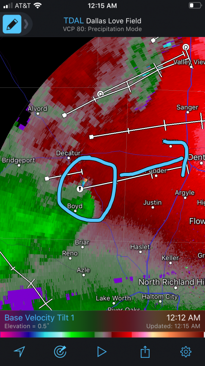
-
Severe Weather March 15-19
Sydney Claridge replied to Sydney Claridge's topic in Central/Western States
I know the HRRR can be aggressive at times with storm initiation and severe storm parameters, but I thought it was worth mentioning that tonight's 0z HRRR run puts isolated supercells through both the northwestern DFW and San Antonio metro areas around 10pm tomorrow evening. I'm not focusing too much on the particular placement though, just the possibility that there might be storms in a potentially-favorable environment. (For instance, if I remember correctly, I believe the HRRR did predict the tornadic supercells on October 20th, 2019, whereas some other models did not catch on to initiation prior to the overnight squall line; I'm not trying to say it will be as bad as 10/20/19 though, especially considering SPC currently says that the risk for DFW tomorrow is only marginal-to-slight)
-
Severe Weather March 15-19
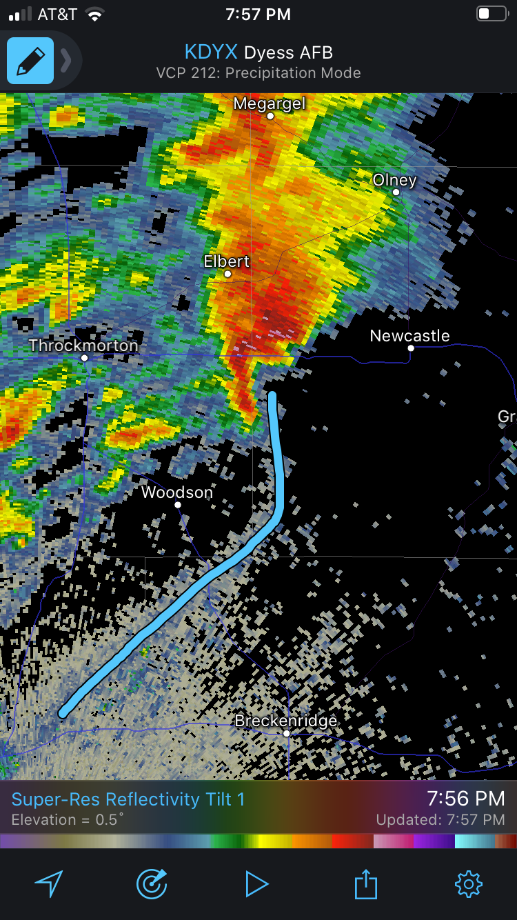
Sydney Claridge replied to Sydney Claridge's topic in Central/Western States
Looks like this supercell between Throckmorton and Newcastle might be trying to get ahead of the outflow boundary. Meanwhile temperatures in the southern reaches of the DFW area (eg. Burleson) have warmed into the lower 70s as the boundary slowly moves north. SPC lowered severe probabilities but if we can get a severe storm it could still be problematic.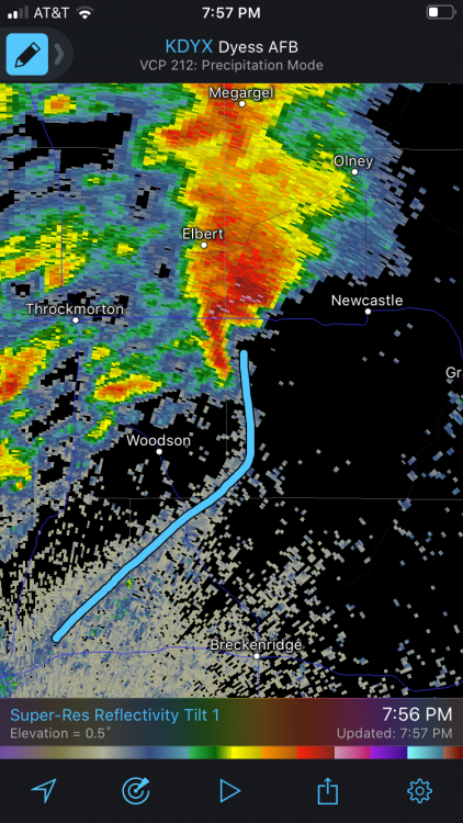
-
Severe Weather March 15-19
Sydney Claridge replied to Sydney Claridge's topic in Central/Western States
Fortunately it looks to be a disorganized mess right now, and they seem to have split into three cells. Meanwhile, I’ll watch the storms out by Sweetwater (currently sub-severe) to see if they try to exploit that outflow boundary left behind from the previous storms. -
Severe Weather March 15-19
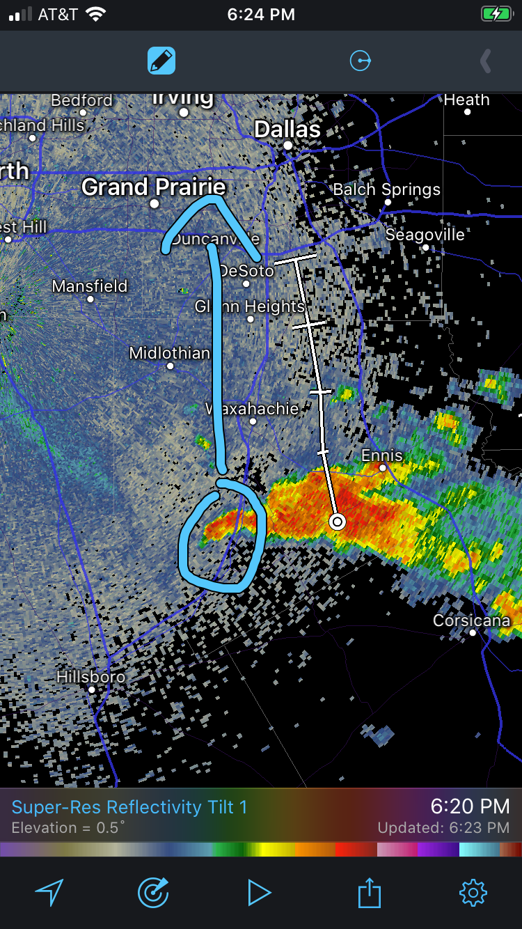
Sydney Claridge replied to Sydney Claridge's topic in Central/Western States
Might want to watch that area along the I-35E corridor between Italy and Waxahachie for the development of a potential hook. Conditions are not particularly favorable for strong rotation (EHI values, both 0-1km and 0-3km, are between 1 and 2), but the storm may be taking on supercellular characteristics based on the radar signature. This storm is also moving straight towards Dallas as well, and if it strengthens it could pose a severe thunderstorm threat. Fortunately there is no velocity couplet, and the storm is sub-severe, but I will be watching the I-35E corridor. Meanwhile, the severe storms north of Abilene (around Haskell and Stamford) look pretty healthy (albeit the one around Stamford seems outflow-dominant based on the radar), and appear to be riding the boundary, although EHI values there are similar to the storm south of Dallas. The storm just SE of Haskell also appears to have broad rotation and needs to be watched.
-
Severe Weather March 15-19
Sydney Claridge replied to Sydney Claridge's topic in Central/Western States
Storms down by Corsicana could become a concern for the eastern half of DFW if they strengthen and continue their due-northward motion. They are currently sub-severe, although there may be an increase in parameters for supercells with time. -
Severe Weather March 15-19
Sydney Claridge replied to Sydney Claridge's topic in Central/Western States
There is a cluster of warned severe thunderstorms out in far western Texas right now. Some of the NAM, RAP, and HRRR runs have me a little bit concerned about the possibility of a "sleeper" severe thunderstorm and/or tornado threat in north-central Texas this evening into the overnight, as a boundary appears to stall over the DFW area with strongly backed surface winds along the boundary. If this scenario verifies and a storm can latch on to that boundary, it might become a bit troublesome. Interestingly enough, there is also a severe thunderstorm watch up for the island of Kauai in Hawaii. (This isn't displayed on SPC's page as a watch since we are talking OCONUS here) EDIT: a severe thunderstorm watch is now out for the areas around Lubbock. Severe-warned storm west of Lubbock is taking on supercellular characteristics based on radar. -
Severe Weather March 15-19
Sydney Claridge replied to Sydney Claridge's topic in Central/Western States
The end of tonight's 0z NAM run definitely looks like it could be pretty amped I would say, with good ingredients for severe weather in place from NW TX and into western OK on Wednesday, not to mention decent helicity in place over the broad warm sector Thursday morning. However, it also models precipitation within the warm-air advection from Texas to the KS/MO border region on Thursday morning, just like SPC said might act to temper the severe weather threat somewhat later in the day ("crapvection" I guess?). It is just one model run, though, so I'll take it with a grain of salt. Nevertheless, the warm sector looks as if it will extend from Texas all the way up to Ohio. GFS, Euro, GDPS and UKMET even suggest some instability could reach into the Northeast (mainly upstate NY and PA) by Friday. -
There is still a lot of uncertainty concerning the extent of the severe thunderstorm threat that could materialize later this week (anywhere from the southern Plains to possibly as far northeast as the Great Lakes), such that SPC has not yet delineated a risk area for Thursday, the day which would probably have the highest severe storm risk. Nevertheless, multiple weather models (GFS, Euro, Canadian, UKMET, plus the most recent NAM runs) all show lee cyclogenesis of a significant storm system over the Colorado vicinity. All of these models have also shown a broad moist warm sector ahead of the storm system. Given all this, it seems like there is going to be severe weather, but the intensity and extent of it is still uncertain.
-
I'm surprised that SPC still has a "potential too low" in their Day 4-8 outlook. There seems to be a pretty good chance that there will be severe thunderstorms later this week, particularly in the Texas/Oklahoma region, based on various model runs.
-
I believe the lapse rates were pretty high with this severe weather event. That could have compensated for the lower temperatures and dewpoints somewhat. This also seems to be the first really bad tornado this year. It’s only been a few months since we had a tornado go through north Dallas on October 20th, so it has not been too long since we last had a tornado go through a densely populated urban area. Unfortunately this time around people lost their lives (unlike in Dallas, despite that being one of the costliest US tornadoes monetarily, and that tornado was probably weaker than what moved through Nashville), and the late-night timing could not be worse.
-
If we are going to see above-normal temperatures and precipitation at the beginning of March, perhaps the severe storm season could start to ramp up. GFS and Euro are both depicting a storm system for the Southern Plains for early next week (around March 2nd), with what seems to be sufficient moisture return across Texas into southern Oklahoma. We are still a ways out, so any model data should be taken with a grain of salt, but the modeled pattern caught my eye (with multiple low-pressure systems moving out of the Rockies on the GFS, and a big storm on the Euro). I'm a little concerned about the late-week storm (that should impact the Great Lakes with snow) scouring the Gulf of Mexico of moisture, though water temperatures are above average across much of the GoM.
-
Need to watch that storm NW of San Antonio for hail potential. It’s just behind the front so I would expect it to stay elevated (and SPC agrees), though the surface warm sector is fairly close.