
.png.5608f5bab30d37cac5ee5443be92fc2f.png)
HIPPYVALLEY
-
Posts
29,476 -
Joined
-
Last visited
Content Type
Profiles
Blogs
Forums
American Weather
Media Demo
Store
Gallery
Posts posted by HIPPYVALLEY
-
-
16 minutes ago, HoarfrostHubb said:
Aggressive move by BOX
Kiss of death, watch all the models start ticking South.

my original call for Greenfield was 4”-6” So I will just stick with that and hopefully be surprised with a positive bust.
-
 1
1
-
-
2 minutes ago, dendrite said:
H7 front right over the bamboo.
That works for my locale in NW MA with the inland deformation banding.
-
2 minutes ago, 40/70 Benchmark said:
GFS and ICON both took a step towards the 12z EURO, just not quite so apeshit.
Ya' but if an ape shits in the woods and there's nobody around to hear it, does it still snow imby?
-
1
-
 1
1
-
-
3 minutes ago, RUNNAWAYICEBERG said:
H7 keeps trending north though. Looks like it tracked along the southern half of the state so we’ll need a bump or two south tomorrow.
You know I want to see you snow more than most here because we are both often on the fringes. However, I don't have a lot of confidence in seeing a strengthening trend in confluence as we move closer. Tics N may still be in play.
I really just want a region wide 6"+ for everyone.
-
5 minutes ago, RDRY said:
Does the CMC rank at the bottom of the big-four globals? It's consistently dreadful.
It's particularly maddening in the winter. It is often showing big snow hits in the Northeast that fade as you get inside of 4 days.
-
GFS solution would make most in SNE happy.
-
 3
3
-
-
Little further N but not zonked. Everyone still does ok.
-
1
-
-
21 minutes ago, Typhoon Tip said:
There's hints there of concentric bands ...that's weaker frontogenic band paralleling that extends roughly MTW to N. Adams up there. Probably a solid band of moderate pivoting in position out there for a 3 or so hours. Greenfield may end up in a gravity well.
That doesn’t seem like something I should be excited about.
-
2
-
-
9 minutes ago, moneypitmike said:
GFS clown has come down to a better sense of reality.
Congrats, James.

Falmouth looks good, should I chase to my folks place? Lol
-
Be nice if @MJO812 and the NYC crew could at least get a few inches.
-
5
-
 2
2
-
-
6 minutes ago, 40/70 Benchmark said:
No, that was Feb 2001
Wasn’t there a big one for W MA in 2002? I was not out here then but that year popped in my head for some reason.
-
1
-
-
5 minutes ago, Damage In Tolland said:
Euro stays the course. Splitting hairs but a bit SE
It looks a bit more north to me.
-
Sun just breaking out here.
-
7 minutes ago, weathafella said:
Right about now a little messenger shuffle wouldn’t hurt for some of us.
If that’s going to happen, probably won’t start to see that until tomorrow?
-
12 minutes ago, ineedsnow said:
Hopefully this holds. BTW GFS is loaded with storms now
It has like 30" for you through the end of the run.
-
1
-
-
8 minutes ago, CoastalWx said:
I could buy that here.
Map seems pretty reasonable. Maybe a little high on N fringes but I believe their algo accounts for variable ratios.
-
1
-
-
Since Ray's not here atm here is GFS narcan totals:
.thumb.png.8dec3b5b9e20e248a1578c531a14cb08.png)
-
1
-
-
Just now, WinterWolf said:
GFS says Icon and CMC are tossed.
They generally are.
-
1 minute ago, MJO812 said:
Lol
.thumb.png.b7f05184d573232d81ffc21c59b7d77d.png)
It’s on an island of its own but that would be pretty amazing. Ray’s family would have to get a hotel room for a few nights to leave him alone.
-
1
-
-
This is going to be a fun day of model analysis of the storm and psychological analysis of the weenies here.

-
1
-
1
-
2
-
-
2 minutes ago, moneypitmike said:
You have transitioned into a bit of a debbie lately. Just sayin
You would know.

-
1
-
-
3 minutes ago, moneypitmike said:
I don't see that lower-end 8" threshold being very elusive for most.
4”- 6” back this way as I fear we never get beyond moderate snow based on the orientation of the better bands.
-
1 minute ago, Torch Tiger said:
the bigger Q is the timing, rather than track.

Tuesday morning disaster commute.
-
 1
1
-
-
2 minutes ago, 8611Blizz said:
If this is a 12 hour wonder like the GFS shows it will be a Godsend. Hit fast, hit hard and go home.
That's the part that's hard to trust as a jaded weenie. I'm much more enthusiastic, than I was earlier today but still cautious of a trend towards shredded S stream tomorrow.
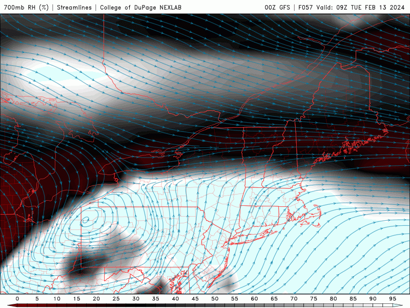
.png.719f1899e89575aa03d234d77c1a7147.png)
.png.1f86f691bbc5b01bce943b1c991bd388.png)
Following a Miller A/B hybrid type coastal potential, Feb 13th ... As yet untapped potential and a higher ceiling with this one
in New England
Posted
NWS Albany pretty aggressive into S VT. I don’t get it? I’m skeptical.