

Typhoon Tip
-
Posts
43,468 -
Joined
-
Last visited
Content Type
Profiles
Blogs
Forums
American Weather
Media Demo
Store
Gallery
Everything posted by Typhoon Tip
-
"generally accepted" is tantamount to urban legend, first of all. Half of common wisdom is in fact 100% fallacy. Where there was intimation that one was better than the other, that is the wrong - we don't know that. That's conjecture and that's fine - that what we do here. Heh. I mean it's all good. But I also like the other point there, that this isn't wasn't an organically occurring virus in nature ( as evidence presently stands ) - so, it is unwise to assume an organically occurring immune system can mount a proportional and winning response. I mean, getting into sci fi ... but, it's a matter of time when human "genius" out does nature entirely, and creates some dastardly thing where there can be no response ... But that's a digression -
-
'Conventional wisdom' ...what wisdom is that exactly ? Vitamin C from an orange vs a pill ... no difference. The chemistry has no distinction in biologic processes. Likewise, the triggering of a T and B lymphocytic response is no different. There's no virtuosity policeman in your blood telling your T and B cells, ' Heh, go easy. You don't have to study for that test -it's only half going to effect your grade' Lol. Also, the whole of the this argument about nature versus nurture in this case has a fundamental logical point of contention ( if not flaw ) to me. Namely, this outbreak and subsequent Pandemic appears ever so, to have an origin in an unnaturally occurring phenomenon. So, shouldn't it be reasonable to question whether a naturally occurring systemic response might be insufficient ? mmm. It seems there would need a proportionate angle of attack - like ... an equally/or better man-made vaccine weapon as a mitigator. In short, it is okay to question natural immune response capacity to actually respond to something that was not natural ( as in inorganically ) in its origin. You know, ..frankly, I want to credit humanity for getting three distinct vaccine forms into Beta workability so fast, like way ahead of the scientific arc timing for these things, as all a conceit of modern tech and for now, ..fine. Let's go with that. But maybe a memo of its origin and how to countermand was also passed into the backdoor of these labs - something that would be possible if they already knew how to do it. haha
-
This whole Delta variant 'quite dangerous' narrative - is that as in, 'more dangerous' ( potency/virulence across the gestation of infectious ability to illness) than the standard pathogen we've all grown to so adore ?
-
Heh.... you mean like the South Park creator's movie? Where they end up going into France and annihilating the entire city over a single terrorist loose in the society there. Socially/politically charged back-handed commentary is their specialty, delivered in the immoral humor much of the time. Go into Florida and sociopathically murder hundreds to get one douche - mm... maybe. LOL "America, F yeah!"
-
Yesterday's utopic bath being matched by today's dystopic bath ... talk about climate balancing! ...what a piece of shit out there today, and oh so diametrical to yesterday's top 10. Diamond to dog shit, boom boom. Series tied at 1-1 I have to admit, this is more pessimistic than I thought - but, ...mm, I chose to accept the NAM RH fields. What an asshole. But that had Logan under 50% ceiling hgt RH by noon, and with 85% in the bottom .. that all looked like partial sun in the afternoon. Not seemin' very likely looking at trends. Well see. I've been fooled into back-peddling before. So, cool bottom dweller day until further notice, and looking around, ...it cookie-cutter SNE and some parts of Central quite precisely. https://weather.cod.edu/satrad/?parms=local-Rhode_Island-02-24-1-100-1&checked=map&colorbar=undefined Here's the thing, despite the underpinning tone of dread to this, there something very refreshingly nice about that cool air. It appears looking at Sat and sfc obs that the vortex - which was rather well modeled actually ...- weakly closed off along the warm front will delay the warm front from coming through today. In fact, it may delay it to never coming through. The weak backside flow will pin it and instead of moving through it will just disappear through Sunday a slow death. It was tough to glean these behaviors out of the charts because the sensitivity was less than standard isobaric intervals at times, making matters look just as likely to be false. interesting -
-
...yeah, in more practical reality, this thing has got litigatin' madness written all over it. Building company(s) and their indirect webbed entanglements et al, right into the governmental inspection offices are all getting probed.
-
Yet if all this is true .. some interest group still made their money - This is why the super advanced, interstellar species have zero interest in first contact LOL. And... as an afterthought, it is why if they ever did come around, it would be because this planet is an attractive target for whatever-reasons that have nothing to do with that which is merely just dust in their way of their accessing it - because the former zero interest precludes them having any arrival based upon peaceful introduction of humanity to the VIP club hidden among the stars. That leaves only one other purpose for showing up - testicle stew Good sci fi right there - totally plausible and closed logic that adds up. Yes, it is true: 1 + 1 = douchebag species
-
Status quo from the guidance overnight wrt to the non-hydrostatic ( heights ) aspect of synoptic evolution, alone - that aspect alone is rather remarkably consistent across multiple guidance sourcing, too. GGEM .. Euro .. GFS and UKM, all place the atmospheric equiv of the Tibetan Plateau over the Bite region E of NJ, and anchor it there from Monday, maximizing Tuesday ...then they begin varying on the evolution of this ridge evolution there after, as a Lakes trough tries to descend along about 90W toward the end of the week. That then sets up either a Bahama Blue ( finally! ..will this ever happen?) along the EC, as similarly, it doesn't have any mechanical basis to move/propagate its wave space through the actual flow, or, it weakens faster and doesn't construct the S conveyor east of it at all. All this prior to another continental heat surge/event that is lurking the American -based telecon long lead - this isn't over after this week. .. but cross that bridge. Re the heat in the foreground; they are fiddling with details that offset impacts. The GFS thinks that an actual cold front will arrive Tuesday by 12z ... Given all, that seems less likely to me. It appears to be either uniquely onto something, or, artificially amplifying the eastern Canadian exit embedded middle tropospheric velocities, with jet shrapnel vort maxima it then says, oh, now I have to BD to atone for the mass flux ... This is an example of how its consummately over supplying cold heights in the Ferrel side of the polar jet gets it into trouble. Even subtle surplus tends to speed up the flow due to ending up on the next interval with more gradient then the other guidance.. It sets up faux mechanical feed-backs As a result, ends up unrealistically placing a west-east boundary from CLE to NYC underneath a suppressive/preventing closed 594 dm heights. The Euro of course doesn't do any of that hinky accelerating/power enhancement crap over eastern Canada, but it's up to something else. It has an interesting tendency after Monday to suddenly dry out the DP. We end up 98/62 at places like ASH, NH. Hot enough ... But, it's unclear why it is doing that when at the time there is a 400 mile wide tube of 70 to 76 DPs from IA to NY in a pressure pattern that should bring that conveyor right fluid continuation in, with almost no inhibition to do so. Something in the physics of this thing is lopping that eastern end off on Tue/Wed, which if so... booya! It would mitigate the risk from this thing on those two days. Maybe there is something to the GFS in the symbolic voice, as both these guidances are picking Tuesday to blindly introduce - there could be something about to come into focus, but I suspect it is coincident noise. The GGEM is the class clown regardless of any day of the year, but fwiw - it doesn't do either of these things. It just limits it's 2-meter temperature to 88 F at PHL-NYC-BOS which appears unrealistic relative to its total manifold -synoptics. I dunno - I suspect of the three oddities above, the GFS is the least plausible correction. Then the GGEM ... Euro.
-
It does ... but, it really interests me that the non-hydrostatic heights over LI are equal or event higher - I just really feel we are dodging extraordinary bullets when these emerge. Playing with fire We haven’t observed a true Sonoran heat release inject a pithy 22.5+C 850 mb, well mixing payload into one of these, not since 594 dm become the new 588. These tall heights can do a lot of damage with ‘hone grown cumulative thermal and consecutive days - like next week’s type. But I wonder if something special lurks and one of theses times 25C will be 850 over ORD with sights on BTV to PHL and Boston, but timing when we’re bulging the tropopause like we will with that atmospheric Tibetan Plateau next week. You wait
-
I mean yeah .. I applaud our local AFD gang here, but wonder ( still ) why CPC wasn't informed - Highlights... * Upward trend in temperature and humidity levels through the weekend into next week. Dangerous heat possible Monday through Wednesday.
-
Which way ... Let's rejoin this discussing circa next Thursday, when we've just put together 4 consecutive daily averages that will ( most likely..) have been +15 by nights, and probably that much by day, to close out the month. I'll be curious how June stacks up at HFD vs Logon. Scott's been aware that Logan instrumentation may need a tuning/calibration. I don't know if HFD, ORH or PVD are putting up contenders -
-
not sure on tomorrow... I could see it doing that, altho maybe 65 DP .. but splitting hairs. I almost wonder if the front has just enough residual convergence along it to spark convection ...Regional lifted index is like -2 by 20z the rest of the way on the NAM's recent runs, so it's unstable in a denser theta-e - those would rain hard too. The 700 and 500 RH is opened up < 60 % indicating it's tomorrow will have decent amount of afternoon sun to add to CAPE, in a noticeably different air mass than today - but getting that boundary layer DP advected in overnight does feel strata and foggy yea. Matter of if that burns off mid day - gotta figure it does under a June microwave emitter in the sky
-
Mmm, yeah it transitions into more a continental heat deal by late Sunday - perhaps Saturday into Sunday .. but it's a WSW inferno by Monday. But speak of the devil, this is really cool seeing these CBs moving N and approaching the S. Coast as that cold front has begun moving back toward the EC as the warm front above... I am nearly 200 miles N of this and I can see these side like anvils on the southern horizon, knowing it is tropical air coming, while the dash thermometer reads 72 and the DP is about 48 Time sensy but here's the loop: https://weather.cod.edu/satrad/?parms=local-Rhode_Island-02-24-1-100-1&checked=map&colorbar=undefined
-
I suspect history, given time, will define that era not so much as a 'dope in Washington,' but more of a reflection the judgement of people that made it all possible ( constituency) and the feckless nature of his rampart of enablers once he took that seat and office. Look up the term 'Kakistocracy' - the definition in greater percentage is apropos. This was not a political distinction that won him that seat - not really. It was a state of morality and intelligence, combined; one that the failures won't admit to, all the way to the grave, too. he was kind of an impish 'bugs bunny' - he really was much more of a distracting puppet entertainer, for/while any interests connected could then benefit from toppling certain institutions that have been stressing their proxy in the marco econ fight - those that will come back, and will eventually place those interests entirely on the wrong side of history -
-
Florida," is apropos as a fully descriptive cause - 'nough said. Seriously, the whole lithosphere there is a honeycomb of underminable salt caverns. The whole peninsula spends every other 10,000 years under seawater... and is probably in the process of being reclaimed again. It's just probably going to start happening where buildings start getting increasingly destablized .. .homes and parking lots and traffic intersections cave downward ..etc.
-
Interesting ... CPC doesn't appear too interested. They have zero hazards anywhere east of the GL for early next week, which is seems odd to me considering this specter has been growing in guidance of three days. hm
-
My goodness... I mean if Tuesday can't make historic heat given this 12z Euro set up rollin' in - it just won't ever get hot here. And we know it does so, heh- At 12z it already has a plume of 20C at 850 mb escaping east of the area, and the surface pressure pattern has a lee side thermal trough from coastal Maine to interior eastern VA.. That's going to be one of those megalopolis 101ers if that is allowed to mature under a 18z to 21z open insolation soak.
-
This is a Sunday through this next Wednesday heat wave. Don't shake a stick at Sunday. In fact ..it is not unprecedented, the entry into a warm departure event sometimes comes in more fervent than thought. I was just looking at the CMC run - which is my last of choice ...but fwiw - that model has 576 dm thickness diurnally blossoming from BUF to PWM and down to DCA, in a WSW wind from the surface to 300 mb as height are rising over 590 ...all by 18z Sunday already. I don't really have to look at much else when seeing that synoptic behavior ? That's straight up over 90 for everywhere. This whole thing seems to have morphed away from an 88/76 Bahama Blue pattern ...into a more standard heat density model .. there is a kinetically charged 850 mb layer involved from the SW that's gotten into the modeling over the last couple few cycles, and the pressure pattern is more STL to BOS oriented now - GFS/GGEM. ...we'll see what the Euro does but it was already sorta there in the 00z run. As Brian mentioned, the point and click was 95 to 100.
-
You know it strikes me of a conversation I had with a co-worker, back before the Pandemic changed things and we'd meet up for lunch ...and dissect the world to pieces with Carrington Events, ... indeed plagues, be it super volcanoes, Canary Island bifurcation/landslide bible tsunamis..etc. Even Fermi Complexes were fun romps. This is one of those Industrial society cosmic dildo events. Like plane crash theory ? Not one thing that brings the bird down - it's a cocktail of serendipity, the consequences of any one is meaningless, but they come to a happenstance nexus out in time ...and in aggregate - etc. See .. 1,000 teepees set out over the grassland prairie of the America frontier west, and all their occupants - they may not live as long? They may not benefit from the abundances and conveniences as we do now. No immunizations. No luxuries and/or accesses to stimuli that we may even operate within that are presumptive. Like we do. But ... when something fails in our world it has to take on this sort of enormity in specter and ghastly cost in casualty density. Trade-off I suppose .
-
Hey Brian ...can you delete my post making a tongue-n-cheek sleeping in, in that thing in Florida? - I didn't realize the scope of it at that time and thought at first it was a construction site that didn't have many people in it -
-
I'm beginning to wonder if that is headline-able heat Mon-Wed ... This 12z oper GFS run has expanded the y and x coordinate aspect of the heights associated with retrograde WAR ... now surpassing the advertized onset of the Pac NW ridge node. Between the two, and having a very weak counterbalanced negative region separating, this is a now hemispheric scoped ordeal with positive anomalies. In fact, said shear axis/weakening trough that separates the two is shallowing out over the last few runs - this is/was true in the Euro cluster too. That is allowing for SW heat release to get sucked up into the continental conveyor. Tracing the 850 mb plume back in time on the 00z Euro ..it originates over New Mexico and west Tx works it's way up and gets caught and trapped under this positive anomaly that has been growing in the last 3 cycles. It's turning into - or trying to ... time to mess it up - a serious heat impact scenario.
-
I mean that seemed a bit like perfect timing for the reaper - Judging by the surrounding ambient daylight, made sure most units had non-suspecting people in beds at that time. Coulda happened at 2pm when most were out or at work but no -
-
I got a hunch the real-estate market just revved further the already hot U.S. property economic engine: " ... Condos for sale!"
-
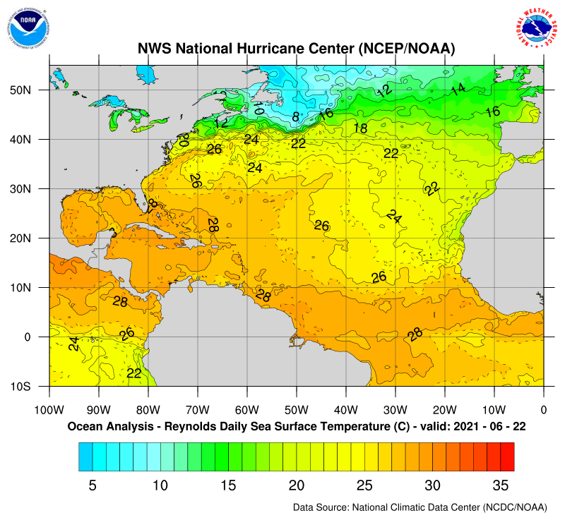
I'm not sure how they get to, "...Although oceanic temperatures are relatively cool across the tropical Atlantic..." with this, Isn't that 83 F ?? More over, it is in fact anomalously of warm measure via multiple sources. Interesting take - ...how warm does it have to be to be relative warm instead - heh
-
Oh, no shit - okay.. well, like we said above, the Euro members seemed sort of interested in that feature. Now, I am not certain of this, that TPC really does model-dependency, but I have noticed a pattern where the modeled spin up regions get yellow X's favorably so ... so I dunno. wait which one - oh okay. The verdi deal wow, 40 % at day 'out there' is actually pretty damn good when considering climate for June. ...I mean relative to that ... I got to say, with SAL displaced N a bit, that seems to open the region to less of that environmental inhibition. Plus as mentioned, multi-decadal OHC isn't hurting either. Maybe this is a good year for an early CV train ride
