Typhoon Tip
-
Posts
44,217 -
Joined
-
Last visited
Content Type
Profiles
Blogs
Forums
American Weather
Media Demo
Store
Gallery
Everything posted by Typhoon Tip
-
March 2022 Obs/Disc: In Like a Lamb, Out Like a Butterfly
Typhoon Tip replied to 40/70 Benchmark's topic in New England
I'm not prepared to aver we can't get so cold in the last week of March of any given year - CC hasn't evolved quite that far gone .. However, in this particular series of runs, I'm thinking this modulates less egregious in time. Model correction trends over recent months (which I'm not sure that isn't still quasi dependable...) has done that too often. There's two factors, that, and because models do this in the spring as a longer term aspect. Those may be mutually exclusive reasons to doubt that excessive appeal verifies quite so harshly. Yesterday was +5 at 980 mb, -4 at 900 mb and -5 at 800 mb at those levels over Logan at sun up...and we still managed low to mid 50s in a sparkling afternoon. We only missed "higher nape ranking" by factor of annoying wind. That's the sun embarrassing a snow atmosphere's ability to compete. It's gonna be cold... annoying... yup. But I suspect as we get near the models back off ...I dunno, some 20 or 30% of that annoyance. The 00z runs seems to hint that already, with the -20 C's less inserting/residential once that happens. If it ended up more a typical late March pedestrian cold wave, wouldn't shock me. As an aside, for muse it seems like the models "forget" the season is changing at this time of year, while rushing matters in autumns - in fact, the GFS usually starts threatening lake graupel air masses by an August 20th, 300 hour CAA - can't wait to end summer. I've actually seen the GFS try to start porking summer in by mid July. I think they have problems budgeting radiate forcing. In the spring, it's like they start at a given initialization, and as each day goes by in that given model run, they cleanse away the heat, while not adding the daily forcing out in time. In the early autumns they over assess the loss. At this time of year, a D7 to 10 they are all the way back to January. There's an air of sarcasm there; it's an exaggeration - but something like that. Different phenomenon entirely, to bowling season antics however... 1997 was 64F on March 29th ... 48 hours later? Historic blue bomb. Although that was uniquely extreme. It was +3 C and 850 mb - if memory is right - on that Saturday. NW dry down slope breeze, still enough to mix super adiabats and swell the BL to tall heights. Basically, perfect d-slope thermodynamics exaggerated the high temp. In fact, I remember having left the Weather Lab's morning of remnant hang-over, coffee and nerd charting ... around 11:45 am. En route to brunch at Fox Hall, ...walking across University Ave Bridge spanning over the Merrimack there ...the CU fractals seemed unusually high based. Their meager vertical extensions leaning over into Kelvin- Hemholtz eddies.. I mused the abstract artistry - the natural hand painted schooners dappled across a vast bay in some kind of regatta, as they leaned over amid white caps. The moment was nape on roids! Tho was but 60, it may as well been 80 under the blaze of March 30 sun ... I've often enough nostalgia over the eruption in spring energy and vitality over the University life as it spilled out of doors across commons... Meanwhile, the hinted model runs of the aft week were as of that morning really designing that storm. -
March 2022 Obs/Disc: In Like a Lamb, Out Like a Butterfly
Typhoon Tip replied to 40/70 Benchmark's topic in New England
I'm personally not buying the magnitude of the cold climate hammer the Euro and GFS are selling D6-7.5, from this range. I'd be surprised if it showing that by this Friday's runs. -
March 2022 Obs/Disc: In Like a Lamb, Out Like a Butterfly
Typhoon Tip replied to 40/70 Benchmark's topic in New England
Well... I guess that's not totally true.. I do remember maybe 5 Aprils spanning my decades on this planet... So, I guess based on that relative sample set, there is a 90% chance of being ass pounded beyond the endurance of man, and a 10% chance that it breaks dandy. Heh, the worst month ever experience for weather ( though ) was May 2005 by a country mile, too. The worst summer was 2000 -
March 2022 Obs/Disc: In Like a Lamb, Out Like a Butterfly
Typhoon Tip replied to 40/70 Benchmark's topic in New England
There's a sneaky good vibe Friday afternoon if the Euro's right. We end up under the low ( latitude) The flow turns west and the 850 mb cold pool lags through NY ...so we'd be down sloping under +2 to +4 C 850s ( but the mixing depth doesn't likely get that tall, no - ), with warm sun swaths... It'd likely bust MOS too cool. I but that's good for 60 or even a bit better before pancaking. Not terrible. Thing is, the models will also tend to overpollute the skies with d-slope trajectories - so it could be better than that looks moreover. Granted, it's not 78 but ... you know, we all need to get a grip and not expect anything other then shit. April is still coming and there's no justification in lore or numbers, that suggest that will be anything other than an unrelenting interminable crime by god itself -
March 2022 Obs/Disc: In Like a Lamb, Out Like a Butterfly
Typhoon Tip replied to 40/70 Benchmark's topic in New England
Oh man ... seems like that' gotta be physically impossible -
March 2022 Obs/Disc: In Like a Lamb, Out Like a Butterfly
Typhoon Tip replied to 40/70 Benchmark's topic in New England
We had flurries in early May last year ...busted virga CU in CAA type... Then that decayed into a weird 70/29 type air mass with huge diurnals for a week. It felt to me like last spring may not have been "as" bad as those others you listed, but it was just smaller piece of CC -caused seasonal lag shit. Frankly, next week's -20 shot is that too - whether it happens or not. ...have that in the area in early April is part of the same mechanism. -
March 2022 Obs/Disc: In Like a Lamb, Out Like a Butterfly
Typhoon Tip replied to 40/70 Benchmark's topic in New England
You likely were not around there in '98/January, but there was a big ice storm all over QUE/NNE ... I wonder how that area did in that. -
March 2022 Obs/Disc: In Like a Lamb, Out Like a Butterfly
Typhoon Tip replied to 40/70 Benchmark's topic in New England
Eh I don’t got a problem with warm enthusiast per se. In fact I’ve been done winter for a couple full weeks at this point. I’m probably more in that camp at this point. I was telling the truth though. That 850 as the GFS has the other metrics isn’t warm. And you bunned the truth … sorry -
March 2022 Obs/Disc: In Like a Lamb, Out Like a Butterfly
Typhoon Tip replied to 40/70 Benchmark's topic in New England
honestly... using a '240' hour chart to elucidate a warm point in f'um march is the bun-able offense. Not the person correcting the user. lord -
March 2022 Obs/Disc: In Like a Lamb, Out Like a Butterfly
Typhoon Tip replied to 40/70 Benchmark's topic in New England
Nah...wet and windy under that 850 ... not as warm as that one metric implies -
March 2022 Obs/Disc: In Like a Lamb, Out Like a Butterfly
Typhoon Tip replied to 40/70 Benchmark's topic in New England
I know ...one's cold with implied coastal bomb chances while the other is only cool and shitty -
March 2022 Obs/Disc: In Like a Lamb, Out Like a Butterfly
Typhoon Tip replied to 40/70 Benchmark's topic in New England
yeah... more than less intimated the same, it could all just be amplified aloft and not do much below. The 12z Euro loses the idea around D7 ...sells reposition of new suggestion out there at D10. Kick the can... -
March 2022 Obs/Disc: In Like a Lamb, Out Like a Butterfly
Typhoon Tip replied to 40/70 Benchmark's topic in New England
It's aight - This message ^^ above is more lucid and intelligent. But the previous exchange(s) were intended for constructively informing you, you are slipping from the central voice in here - in hopes to elicit some sort of awareness on your part. It was not abundantly clear you understood the ramification/connection of the dots on that stuff. This above shows you understand - good. Start with adjective herding... don't use the word blizzard - Listen, there's a short list of verified blizzard condition events, per year, spread out over the entire country. Any one given location has a very low probability of ever seeing one in a given winter. That should/could suggest how often it is really "utilitous" to refer to any given mid or extended range event as a blizzard. Almost never... If you disclaimer your self as an artist or story teller of sorts...that's entirely fine - in fact, you have a native flare there ( perhaps). But when one drops these a-bomb dystopic thrill seeking winter nuke posts, that just don't really follow from or match, as though to be taken seriously, that doesn't leave folks much to go with. -
March 2022 Obs/Disc: In Like a Lamb, Out Like a Butterfly
Typhoon Tip replied to 40/70 Benchmark's topic in New England
The best that I can tell ... from that particular source there is almost 0 filtration through Meteorological machinery in the formulation of post content. There's some vague toe-hold on reality, only for the that the user starts with a chart, but from there....? It's really like sitting through a Looney Tunes day dream of "Ralph Phillips" Eventually ...if this has not already begun to happen, this individual will start getting ignored altogether if he doesn't modulate his tact ... I tried constructively to warn him of that destiny, yet he replied with post like, "Yeeeeeah I don't think that's gonna happen" I don't know what you call that. "Pull the gun out of your mouth or you might blow your head off" --> "yeeeeah I don't think that's gonna happen." It is what it is -
March 2022 Obs/Disc: In Like a Lamb, Out Like a Butterfly
Typhoon Tip replied to 40/70 Benchmark's topic in New England
Looks the same as it did yesterday when I brought this up ... ... an emerging signal for amplitude now ~ day 6 - 8.5, but the last 24 hours of runs haven't provided much confidence in what that will be. It may only express aloft. I was looking at the individual members of the GEFs and about half have some impressive evolutions at 500 mb, from the MA to off the NE coast ...roughly D7 .. 7.5, but then you go look at the sfc? garbage - Still appears destructive interference is going on out there ... which may or may not limit this potential. The big bag of trough garbage in the mid range that wobbles and contorts its way through the east does two things: one...it normalizes the thermodynamic gradient but perhaps more importantly, the wave space between its aft/exit aspect wrt to the amplitude diving in, is too short. Because of that, the wave coming in can't pop crucial lead roll-out ridging, such that would feed back ...slow down, situate/cross up jet axis ... blah blah big storm. The GGEM nicely exemplifies this type of 'starvation' result. It slowly deepens a middling low over 18 hours. It has spring snow in mid level forcing... All this could modulate more developed, but the total wave spacing needs to either open up ...or less emphasis in general in handling the mid range ...such that it doesn't evacuate ambient baroclinicity and/or back-impose wave spacing contention. -
March 2022 Obs/Disc: In Like a Lamb, Out Like a Butterfly
Typhoon Tip replied to 40/70 Benchmark's topic in New England
It looks to me like we have an emerging signal from the mid Atlantic to coastal New England, ~ D7.5 thru 9.5, but of what? There is likely to be L/W amplitude positioning thru the eastern continent during the time frame; that much is actually above confidence for me. But there is all kind of destructive interference ...that really begins much sooner in the individuals operational versions, and blends of all. The trouble is, the models are bunching a lot of noise on the front side of that more important period of time. The D4.5 - 6.5 period features a sort of typical spring climate, half commitment bag of trough that in itself is tussling with internal mechanics. That whole mess then advects stage right, cleansing away the thermodynamics Better player mechanics then arrive into a dearth of baroclinic instability ... ends up less. Not for not, ~ 1/3 of the GEF individual ( 00z ) members, manage to engineer at least a middling low that strafes the MA to NE region thru the above time range - slow mover. Spring blue judging by the marginal appeal/540 < hydrostatic height coverage while that is happening. The others don't do this/ keep destructively interfering. -
March 2022 Obs/Disc: In Like a Lamb, Out Like a Butterfly
Typhoon Tip replied to 40/70 Benchmark's topic in New England
IMHO the NAO might be partial but the mor important change is the PNA bouncing around positive every three to five days aft of the recent -EPO that’s long gone, but residually, having loaded cold in Canada, this could lead to trouble That could mean bowling trouble … pretty much hitting climo too. 18z almost parroted the 12z Euro in the fantasy range … Not a testament to possibility … yet, but a testament to the vulnerability in the physics right now for these possible deep pinch lows -
March 2022 Obs/Disc: In Like a Lamb, Out Like a Butterfly
Typhoon Tip replied to 40/70 Benchmark's topic in New England
O K out of no where … 1 pandemic 2 nearly avoiding a nuke exchange 3 then a biblical cap failure sends a 20 foot sea level rise all over the world only that tsunamis doesn’t wash back … bring in the locusts I guess -
That‘s that gust of it yup.
-
March 2022 Obs/Disc: In Like a Lamb, Out Like a Butterfly
Typhoon Tip replied to 40/70 Benchmark's topic in New England
You know what that is... ...that is merely missing a S. stream zygote disturbance to fertilize, because if it had that... it would be historically competing with 1888
-
March 2022 Obs/Disc: In Like a Lamb, Out Like a Butterfly
Typhoon Tip replied to 40/70 Benchmark's topic in New England
Now this is a bowling ball !
-
March 2022 Obs/Disc: In Like a Lamb, Out Like a Butterfly
Typhoon Tip replied to 40/70 Benchmark's topic in New England
Here's what's going to happen... The broken line of convection will orient into a linear feature and propagate into western zones later this evening, pushing an outflow out ahead ...and that will scour out this shit ...or perhaps even ride over the top... but it will at least assist in doing so... Then, as the main cold front comes in the aft, it the brief gradient packing ahead will do the rest and there will be a mix-down T spike like 5 minutes before the front goes through neighborhoods ... .... at which time Kevin will either be already asleep, or ... posting how the models were right about the warm front busting in to NE Mass. -
March 2022 Obs/Disc: In Like a Lamb, Out Like a Butterfly
Typhoon Tip replied to 40/70 Benchmark's topic in New England
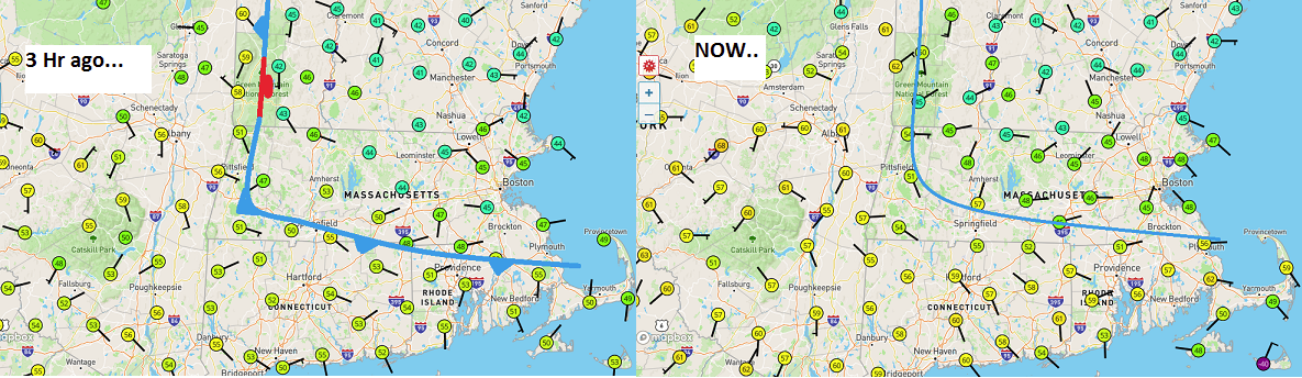
despite your narrative on the day's proceedings... the boundary has not appreciably retreated back N as a warm front - sorry if reality and empirical data doesn't fit. Don't blame the messenger. I mean ..there might be some mixing along that leading edge there on the right panel ...but that is not attributed to warm fronting. The winds have to go essentially calm where you see the wind is not calm and blowing from the NE with those wind flags - Can't help you. This probably does break down as the main front tied into the baroclinic axis is moving through... You'll get a 10 minute T spike then a west wind or something. If we wanna argue the BD front won't make it to CT, I never said it would. I said it isn't clear whether it will or won't.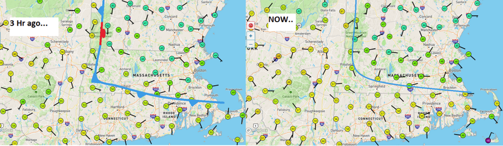
-
March 2022 Obs/Disc: In Like a Lamb, Out Like a Butterfly
Typhoon Tip replied to 40/70 Benchmark's topic in New England
Well well well well... PF finally gets to feel our low elevation, east of the Berks April pain lol