Typhoon Tip
-
Posts
42,090 -
Joined
-
Last visited
Content Type
Profiles
Blogs
Forums
American Weather
Media Demo
Store
Gallery
Everything posted by Typhoon Tip
-
Ha haha .. this may be the most destructive hurricane to ever impact the NE alright - a hurricane name "Cried Wolf" will destroy any uncertainty regarding weather forecast competency, affectingly removal of any doubt -
-
The lower level would need to be feeling the steering ... It's not a bad approach to figuring it out but it looks like there's still shear in the mid levels from the NNE. I'm beginning to wonder... we may not see a shear abate from that source as much as perhaps anticipated, but similar to what you allude to ...wait until the llv and mid level convection begin to move along with the SSW flow over the eastern arc of the U/A low closing off, that is window of lowering relative shear. pure speculation.. But as far as what is plainly evidence at this hour, the shear is still hosing this...
-
Word! This thing looks like shit to me at this hour frankly. I keep seeing a flurry of post about explosions and detonations and go look and heh wtf are we looking at. Nick's post with vis loop - it's hard to argue that the inner sanctum of rotation isn't about to pop right out of the convective foreskin on that NW side. Things can change in a hurry and I am not 86 any forecasts here at all - just the now-cast gripes.
-
Yeah... time to update/re-install some concern spectrum: ... tornado threat with this spread out over all of SNE and probably the southern half of CNE ... There is a flood concern that is rather obvious shore to rain inland, which depending on where this land falls may be west at first... But if it does slow and meander E through southern VT/NH... that can be 24 hours training water boarding and massive problems if that happens. It's figuratively as though the dramatic "20 minutes" of land falling is 20 % of the crisis -
-
These land falling systems don't spin up - or tend to ... - the bigger violent types. They tend to be smaller 0 to 2 leveled whisking by. Which 2 can be deadly ...hell, 1 can be deadly. So can be a sunny day if the husband catches you with 'er - But systemically the trade off in violence is the 'swarming' numbers, in that there can be a lot of rad tripped warnings and dangling ropes
-
Was just about to post this exact couple of sentiments - ..and despite the air of exuberance in mood and posting spin, this is still all based on what ifs - granted, more plausible than 'what isn'ts' but ... storm enthusiasts that want to see their neighbor's property denuded from the face of the planet while leaving theirs ...unscathed with power still entitled and in tact, will need to get some realization of intensity/organization profile cooking here.
-
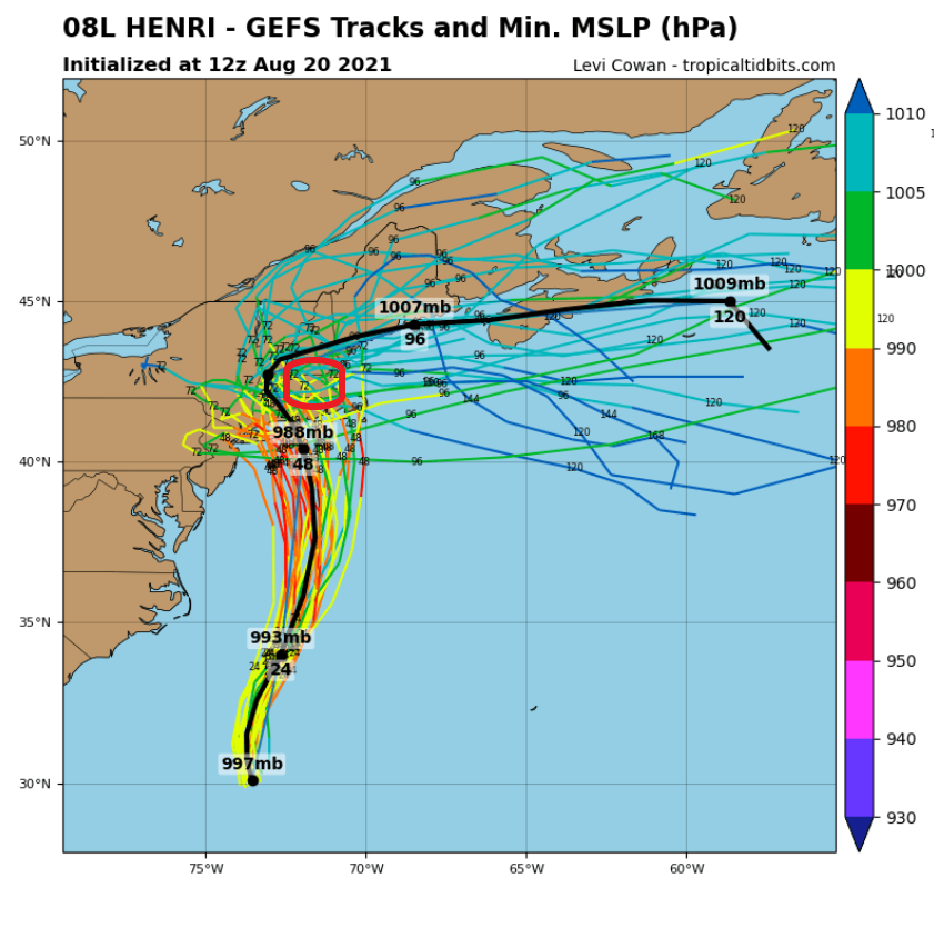
This red annotated region in that track wedge may as well mail in the insurance forms now ...cuz that's liable to be one contiguous tornado vortex if this ens mean works out...

-
It's definitely tactless and insensitive - I'll give it that ...
-
it's here : https://www.weather.gov/box/1938hurricane
-
That might actually bring surge waters into downtown Providence in that scenario. I think who's a 1938 aficionado ...I'm almost certain there's a high-water mark around Town Hall that has the 1938 ... I may be fantasizing that ... but, that Buzzard Bay in a bad bad spot for that stream line analysis - heh. Actually edit: that's kind of a weaker system there... well, maybe not. But if a stronger system moving into that position would be -
-
Which ironically may become "ass - buried" park.
-
I was just looking at the tide charts for NYC ... Looks like the 8:55 am Sunday tide ..should the west correction become more real, is unfortunately timed rather well with the approach to the coast that morning. If this thing is a category 2 and it is moving headlong, bee-lined into the Bite region on top of that high tide cycle... oy
-
Eww... If this thing were to RI and expand ( no, that doesn't mean Rhode Island), essentially becoming a very prominent physical reflex in the total synoptic field ... that can and likely would reflect in modeled track guidance. Sucks, this thing's capacity for mayhem is in a sense, hiding in plain site - I large Category 3 hurricane interacts with a weak U/A steering field differently.
-
You know ... I've spent some time this morning outlining some of the uniqueness vs comparisons to past, re this whole thing. Some semblance in governing synoptic players that in principle are similar to Sandy - but differ in exact orientation and amplitude...etc..etc.. But the uniqueness of this may be slipping away to that sort of nearer term modulation you're demo represents above. That's starting to try and look or 'trend' in a more typical climo set up ...it's not there totally. But trend - interesting...
-
Okay ...you're talking about something else: impact specifics ... I was just referring to the meteorological shit. Heh... Yeah, I wouldn't care to debate the other popsicle headache discussion. It's subjective to experience making that non-influential, but objectively, there's not likely to be any empirical comparison UNLESS this thing Cat 4's outta nowhere and expands radii and all that... who knows. I lost my internet connection for 20 minutes so -heh, may have missed some of that leading posts. sorry
-
Mm, the blocking node/-NAO with the U/A capute are very similar - There's a amplitude difference in those conducting large synoptic events, comparing the total manifold of Sandy and this, but in principle they are most certainly similar. A Sandy comparison is not BS - sorry. We can't get cute with exact parametrical comparisons - first of all, that's a snow-flake comparison argument. Second, it only means anything to petty squabbles in the social internet; 90% of the civility between Cape May and CT is not going to engage in pettiness. It came from the E in both cases and fugged up their lives. Science can hyper categorize later on after the dust settles... and probably those quantification efforts would reveal more that 50% likeness -
-
It's probably a silly subjective 'philosophical' take but... "ages" in that context - in literary circles - just means the impact-affects at cultural scales, incurring changes in modes of thinking therefrom in aftermath, and modality of means. The more so, the greater the 'age' of distinction? In that sense... Cat 1 ... 3 ... 5 means nothing. A stalled tropical storm in Texas in the 1970s dumped 40 " of rain and that changed the climate thinking of what can happen in Texas, and probably ... led/helped constructed Harvey response/understanding at least a little...etc... ( May not be the best example but helps the point - )
-
The "fanning" characteristic over the entire N outflow at upper levels is more indicative for me. But, in this case it may be 6 a dozen or half another because the better symmetry aloft may in fact be physically tied into that 'pulse' As far as the pulse its self, in a vaccuum it means less to me. We see these flare ups and have along the way, with Henri and every thing in history Lol. I think also we collectively are like carpet surfing crack discard for the petty nugget find to spark off in our pipes ... j/k. I love that metaphor. Seriously though, I wouldn't be surprised if we are seeing the instensity about to bite down hard over these ensuing 12 hours. I'm a little bit concerned shy of bun-merit for the anecdotal climate of how systems that make it through hostile guanlets and live to strengthen, tend to go a bit crazy - it's almost like they have stored momentum/battery that adds to the environmental favoring, and they like synergistically get a feed-back. interesting...
-
It's a matter of scale with that. At smaller scales, a single home can adapt quickly for obvious logistic easy and access to compensating means ...etc. At society scope -? Nope. Panic ...given time. Social order break downs and anarchistic phases of discord will get scary. It gets into the darker humanities of that kind of violent hording/pillaging ... climbing over the injured in survival fight or flights for potable water, food of any kind by those that have 0 skill but 100% acclimation to the industrial bubble - which ...unfortunately represents 90some percent if every person. With nothing moving any longer along social order.. basically, an apocalypse being a dimension of scope and scale that no one really thinks about because let's face it: The Grid is sort of assumed? It's probably more a philosophical sojourn/sci-fi thing for the banter thread, but ... nothing about Henri imposes that latter extreme scenario, no. Haha. Obviously we'd need something of a different order to bring about that ... I dunno, Yellowstone, a Carrington or comet impact event ...
-
Yeah... they're being unkind in the bun Tsunamis but ... if you are really on the Jersey shore, I would not assess "storm impact gaining traction" for your location. In fact, if it approaches CT from the SSE, you may end up in strikingly beautiful lighter winds pushing 79/75 tropical balm, while the heaviest rain is up the coast toward NYC. Trauma of Sandy may guide more so than present 'clearer' impression of threat assessing, but ..as there are no certainties in the weather-related risk game, it can't hurt to be prepared. And one should always monitor, either way.
-
Oh ...shoot - missed ur op to fug with folks there. You should have put a big H in the mix-
-
Heh... right - sure they do. Until it shows an ISP to EEN track at 920 mb, then, '...There are circumstances where this guidance can be trusted though' lol... J/k... There are in fact circumstances where it can be trust ... though tropics and interacting tropical phenomenon with the westerly complexity is not one of those circumstances.
-
Will and I were discussing that last night, AGREED... Folks'll need to come down off the 'we may not get the direct goods' disappointment first, but the old adage of not focusing on the exact position comes into play. A compromised track that goes NW or NNW through say ISP-HFD as a rought axis, probably sends E0F .. E1F tornado swarm over all of RI and central/E Ma and southern NH.
-
Yup ...add that to dizzying array of components to this thing. Is the timing of the ET even right...