

Typhoon Tip
-
Posts
43,440 -
Joined
-
Last visited
Content Type
Profiles
Blogs
Forums
American Weather
Media Demo
Store
Gallery
Everything posted by Typhoon Tip
-
So I think what's gong to happen ... the oper. GFS will correct toward the Euro for the Mem day weekend. The 00 renditions are in reasonable agreement, wrt to the handling of that trough eject through the MV at least through D4 ... but they part company rather extremely as that mess approaches the eastern seaboard. The GFS over-deepens the Rockies aspect on or around D6 ..7, and that causes the immediate downstream wave lengths to buckle between 90 and 70W. That scaffold grabs the vestigial trough remnant, closes it off, and sends it S astride the MA over the remainder of weekend - which I think is bs overall ... My hunch is that the GFS tendency to lower heights in troughs and nadirs, too much, is causing all that. Fwiw - the 06z corrected the D4/5 west, and that immediately corrected the structure along the EC ( transitively) ... As we age through these days this week, we'll likely see more solutions like the 06z ... 'fill' it in, wash it out, more so like the Euro.
-
Just adding an opinion here to that... Anecdotally based on my own observations, since the 1990s, that seems to be more and more observable - a kind of 'correlation breakdown' increasing in frequency. All winter long it was remarkable watching the La Nina decouple, ...recouple, only to decouple... The MJO was faux attributed to forcing circulation modes, only to have the weekly publications have to abandon the previous week's assessment/causality. Couple of examples of longer and intermediate terms teleconnectors there. But even the intraseasonal/weekly modes have been less dependable.
-
Wrt to the Euro 00z run... Not intended as prognostic or deterministic effort. This is just a scalar implication of that 192 hour synopsis. Spanning the Corn Belt/Lakes region around 168 hours, a circumstance approaches a "Pacific NW" heat event. Probably would not match that exceptional rarity that took place up there, late last June, but both then, and this Euro now, are examples of "synergistic heat waves. " Their exact magnitude comparison aside, the phenomena is paramount. 24+ C, 850 mb temperatures looms over the entire region, with pock nodes to 25! (indicating 850 was adiabatically breached) over a region the size of Texas. Leading, modest seasonal rain deficits. That will edge the thermodynamics toward the drier theta-e side of the "heat dome climate" typology. Then, under solar max radiative forcing. That is an over-lay of less-than-obvious initial conditions, silently interacting factors that support one another: the results exceed the more obvious (non-silent) input metrics. Earlier expansion under very intense sun, feeds heat back in... etc. The system over-achieves. Hint, we don't want to over achieve +25C at 850 mb over Chicago under June Sun Bottom line, connotes historic temperatures. It would be worth looking those up out that way, should this 192 ( would last thru D9 too), become more confident/urgent. Possibly all-time of June. That scenario on there looks on paper like antecedent circumstances are converging there. Questions is, ...where does that go? Not sure it's going to ever get here...but that's close! The Euro has been signaling this -PNAP surge for the last 3 days, ...the EPS has been on board with at least moderately expansive geopotential anomalies. The -PNA over all is clearly the footprint hemisphere leading, so ... in wait of happenstance timed/embedded wave mechanics than super-impose a ridge genesis, is also a bit of a positive feed-back. The operational Euro run shows less restraint in synergizing all these factors. The ens means of the GEFs and GEPs have been more similar to the EPS for May 30 thru June 4th or so during the last three days, which reflect solutions that don't support those erstwhile GFS close-happy offset.
-
If it weren't beyond D6 I'd say we have an epic model battle going - the problem is, that far in advance sort of gives them all a lot of latitude to f-up. I think if we're still in disparate state on D4, the fight's begun?
-
out of the GEFs individually, I saw 6 total that could offer support to the operational version for Sunday/Monday. Otherwise, none do - the operational is also the most amplified of those members that do carry the closed low/weakness shit parade. They are in the minority.
-
oh Brian beat me to it .... right ?
-
Jesus.... I cannot imagine a synopsis for Sunday into Mem Day, more diametric to the GFS than what the Euro has, without it just being on another planet. It seems to me there are two sensitivities vying for 'f-up the holiday rites' 1 -NAO; it's out there as a wild card. The Euro's been flip flopping with magnitude and placement. So has the GFS... But in either scenario, if that gets westerly limb over the domain, we have BD issues regardless of the closed deal - so this is kind of a personal obs/addendum. 2 ...that closed low. The Euro has zero, the GFS is miserable... the GGEM is in between. The Euro actually sends Monday afternoon toward HHH while what ... 52 with east windy rhea into CC Bay on the GFS. Note, the NAO can often be modeled negative, and just not be negative when the time comes. It may not be factoring ... just sayn' so long as it's there.
-
GGEM looked better to me - fwiw. still ends up with piping high retreating E ...which isn't hugely warm, no. But it looks fair aloft
-
yeeeah.. on the fence personally. That weird cut off three weeks ago, that pinched at first as though it would stay E and spare, ...did that huge clockwise track spanning some 7 days...only to come back up the coast as a smearing vestige. It also served as an 'inverted block' because the high pressure initially over Maine couldn't sink SE of the Cape. It was sort of anchored in a position to keep us in an east flow. Remember? I mean it was like 4 dry but cloud days with drilling E wind, followed by 4 sunny but still drilling E wind when all that happened. These inverted blocks happen too - This thing that the GFS and GGEM reverted to in recent run cycles, hint at doing a similar inverted aspect ... hold the high to a N position E of Boston. That said, the cut off isn't anywhere close to the same frame-up momentum, as that big gyre back whence. The other thing, I've noticed this in the past with models over many years actually - they seem prone in the mid range to disproportionately drive surface responses from weak mid level mechanics. The GFS has a single close 500 mb contour, ...filling at that, as it rotates closer to the MA. Yet N of up the coast results near gale CCB coming into the Bite of NY. I don't know if that's really true - seems a bit too much of a response.
-
Mother's day was ruined... Now mem day weekend destroyed by the GFS... ? Starting last year, that makes all holidays destroyed in a relentless series spanning over a years... kinda interesting
-
My personal hunch is, that will continue as we press further onward into/thru the warm season. Then, next autumn, GFS model performance will improve again. Lot of words to describe what is subtly, albeit importantly different between the GFS operational run and it's competing other model types: As faster wintertime basal state geostrophic wind velocity, once again, proves it is the new paradigm during winters ... first creeps on during OND ... the operational GFS model then 'defaults' back to having that uncanny performance edge in that D6+ range. As an aside, I noticed all this and its knack for that, began during this era of more rapid version upgrades. Hypothetically: 10% better in performance, at that range, isn't saying much in terms of larger/super synoptic handling? No. However, small movements with big objects can have ginormous impacts at smaller sub-continental/regional scales. But also, these small morphology matters to the behavior of storm genesis, as well a 'atmospheric logistics' with embedded features et el. This may be why over the last several seasons, the general voice has noted the Euro has faltered to the GFS more and more during outer mid and extended handling. In short, I believe it's because the GFS' speed biases - but here's the thing. It's not 'right' per se? Its error is being hidden by the tendency for faster overall hemispheres ... it looks right. The old adage, 'right for the wrong reason' The speeding tendency is a cumulative one - it grows out in time ( I have noted..). By D6 ... 8, particularly in the winter season, it will routinely be some 6 to as much at 10 dm colder N of the jets. That steeper gradient ...instructs the higher velocity. It's simple. Something about it thermal dynamics of cloud and latent heat and UVM budgeting complexity in the NCEP's version of Navier Stokes LOL. But that model isn't necessarily going to stop attempting dump cold into vortexes, just because it is summer - necessarily. summer, vs winter. It may not apply in this case with Mem day... I'm just op-ed'ing about it. It seems all the models are having difficulty with the -NAO mode change. Dimensions of volume and timing ... I think if we -NAO, there's going to be a BD proneness, too
-
Mem day heat
-
Yeah that’s prolly right. still interesting.
-
It just occurred to me… 20 years ago on this date in 2002 Worcester had an inch and a half of snow and we had cat paws in Waltham at 38° in a wind swept nor’easter… Pretty sure that was 2002 and May 22… Or something like that
-
We may split next weekend ...end Sunday into Monday in a heat surge. But yeah, some of these days this preceding week could be real massage weather. wow. Talkin 77/48 type stuff
-
What's the daily record for Worcester ? Mesowest has 89.6 ... depending on that site's funky rounding method, .. a new METAR should be arriving any time now.
-
I think you're going to have a better shot at this on Thursday/late .. into Friday .if timing works out.
-
This is an impressive note.
-
Me neither ... that other goofiness aside, I posted about this a couple hour ago. Heights are following only slowly ... The front seems like it's paralleling the flow.
-
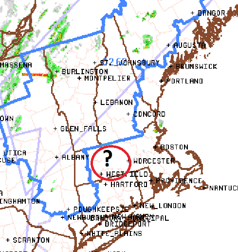
I've always scratched my head when they do this kind of illustrating ... Obviously "in or around" should suffice, but is it really impossible to be a little tidier? - haha. Danbury CT, and Nashua NH ... bombed. But that light sprinkle in Orange MA? Phew, that almost shut things down, huh Is it really hard to just draw that from HFD to PWM and call it a day? I think it's pretty clear they relay upon county lines - or I suspect so ... - and it may not be convenient to do so, but this technology isn't like DNA - it's not causing cancer if they change how they f'n do that. Guess there's more important problems in the world.
-
yeah our winds here along Rt 2 are convincingly W to WSW.. 94/66
-
I bet the warm air floods out to WInthrop over the afternoon..
-
Impressive... BED 97 ! 93 here
-
I can see the tops from here ... Appears a wind shift is working E. We've gone WSW to almost due W here over the last hour, with more tree top movement .. Probably 20mph over the canopies. anyway, it appears there is a convergence there where that lingering SE inflow is being met by this pulse moving E, situated over NE Mass
-
of course ... a mid level deck start emerging.

