Typhoon Tip
-
Posts
43,440 -
Joined
-
Last visited
Content Type
Profiles
Blogs
Forums
American Weather
Media Demo
Store
Gallery
Everything posted by Typhoon Tip
-
As an aside... it seems to me just a-priori for the experience, that June was held down due mainly to dry air pulling the nighttime lows down, when actually ..the daily maxes were above normal. It was a matter of averaging magnitude in either regard, and the lows won by like -.2 of whole degrees. And even though July is, so far, modestly above normal, it is still being taxed by those desiccating air masses/ soil moisture memory. That's kind of interesting, if true. Because as we know... many of our above normal months ... dominating the anomaly vectors since the year 2000 really ... have been cited for having elevated lows in fact tainting the monthly means. So we've actually just gone through 6 weeks of antithesis to that.
-
Yes ... the recent era of merely above normal has to soon yield to even more above normal era ha. But I'm not sure how hot it will be next week? Because that looks like more home grown heat. We don't really have a W/SW releasing synoptics lending to that period. The lows will elevate over recent noctural behavior, though. 66 to 72 DPs with zip advection means to cleanse the continent will tend to stifle nights from falling. Need to think of next week as entering a regime change - I mean it's not a novel insight ..the models indicate the humid week coming. But the so-far July above normals at the SNE climate sites (+1 give or take a decimal) will likely no longer benefit from dry radiating desert nights. So that'll likely gain starting Sunday until further notice.
-
Mm ...I actually prefer the GFS for Monday afternoon and night's rain styling... The Euro looks too balled up and concentric with that low - smacks as feedback. The GFS fits the synoptic motif better, which features more subtropical ridge resistance ..so troughs and fronts are apt to laydown positive tilted, and we end up with those strafing bands of showers and thunder. Quasi training ..where you clip by a cell moving NW of you then you get one ...then the next clips SE so you get two thunders in the aggregate lol... But that looks like our first run-in with truly soupy air. 65 to 70+ DPs legit and deep in the BL with sun to 84-87 Monday afternoon... Good rains could take place.
-
Folks ... if you're not under the rain core of fast moving small scaled convection cell .. yeah, you're apt to getting sprinkles. deal with it. lol..
-
It's a tough call... Telecon's are useless right now. Have to go on the tenor of the operational trends and mash 'em up with season and persistence. Even in doing so you get a kind of even money on which side of the ambient front we'll end up next week.
-
Looks like it went about half way back to the 00z's heat complexion next week
-
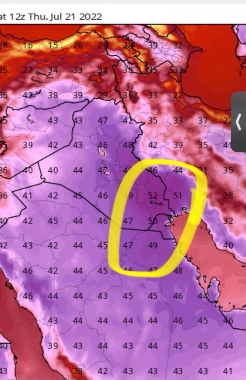
interesting synopsis next week with the area flirting with heat wave if not succeeding, without much of a traditional ridge impression. It's coming by way of flow relaxation which was advertised beginning last week's indicators - posted about it.. .but it's interesting that the +20C 850 isotherm creeps up to the 45th latitude in some of these recent Euro runs, really without a very define presaged western inject. The GFS has that weird miasma of frontalysis and air mass convection that it's using to generate what I suspect is a model-artifact cold pooling in PA/NY and eastern OH bleeding into our area. Suspect model feedback... in fact that 'front' appears to spontaneous occur where that air mass stuff festers. Noticing it and the Euro have 75 DPs pooled in that area... The GFS just has always hates low level moisture since the MRF became the GFS... Likely to be a more convincingly elevated DPs ... and with that some air mass instability is understandable.
-
Stop having fun! ... we're all doomed...
-
"Dave ... Kevin here. Hey bud, can you tweet about hell on Earth cuz ... you know it's like true right -"
-
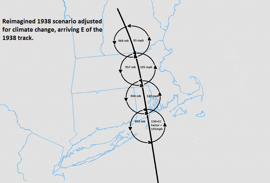
Right now... that's triggered Kevin to frantically surf Tweets and Google New England dystopian death drought 2022 to regale us with some pablum's dire warning or a chart taken out of context to fluff the sensationalism of our collective demise.. lol
-
Y'all 'ill train convection some night here sooner or later, and down a couple inches of water. At least for my own melange of grass types (the only species I don't find out there is crab)... it won't fade back green like that. What it'll do is start sending up new green shoots amid the beige carpet. I've seen that often when summers go through a desiccation period.
-
um... no
-
We actually were making out well with the aridity around our town along Rt 2 in N-central Mass...until about a week ago. While most had been waving the drought flags, we were one of those lucky locations that got a couple of random downpours earlier last month. That's all dramatically changed in the last week. Most yards around town went from hold out green complexion to tinder looking tan. I wonder if flag warnings are going to be needed soon. My own lawn is pokey straws at this point... very quick transition from salad to kindling over the last 7 to 10 days.
-
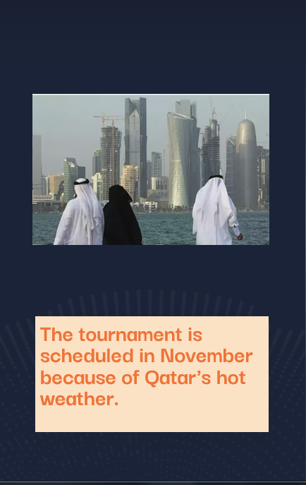
Where did you hear/read that specifically ... I just read ( actually ) a different report that says it was move to November in 2021 because of the Pandemic. Now they're saying Qatar heat ? I dunno - both aspects can be true I guess. Boy...our weather must be boring, huh
-
Heh...it was actually postponed to then - apparently .. - because of heat in Qatar https://www.fifaworldcupnews.com/web-stories/2022-fifa-world-cup-postponed/
-
Check out this rectal plaque … apparently a World Cup game was postponed because of it.
-
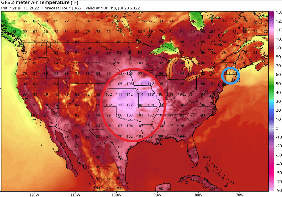
well... it kinda isn't, because that's cloudy murk and misty light rain east flowin' rhea. I mean, obviously at 384 hours discussion is not warranted, just sayn'
-
I just saw an internal memo that exposed that the modeler's are doing this on purpose, interestingly enough... The exact motivations for parameterizing/forcing the run to illustrate this physically excessive disparity, and seemingly deliberate singling out of SNE ...was not explicitly elaborated but the experiment was an apparent success -
-
annnd that means you work directly with clients, then? sorry - I know nothing of social work. They allow you to prescribe medication with a Master's degree though ?
-
I guess you're manacled to the blazing speed of changes in state protocols and accessibility ... so Remote work won't be an option until the grid actually fails, at which point it will be moot -
-
This whole mess today was moving along at the rate of winter synoptics. anomaly in that regard.
-
Oh .. I forget. That Hurricane Kevin
-
I do this too - it's gotta be the abusively unrelenting jet pattern configuration that looks like I'm convinced of its subconscious directive dreaming influence. haha

-
If they survive scrutiny and the rounding convention shit ... a lot of sites are nicking 90/ dp in the 64 range Not bad. We should be good for 92's ... probably the hottest day in recent weeks, I'm guessin'