Typhoon Tip
-
Posts
43,406 -
Joined
-
Last visited
Content Type
Profiles
Blogs
Forums
American Weather
Media Demo
Store
Gallery
Everything posted by Typhoon Tip
-
heh... exactly what I was said in my mind when I read that, 'welcome to our spring'
-
Setting the table on a possibly "moderate" impact winter storm. Perhaps the most promising event to date, this season. Presently... Radar upstream argues for a stronger precipitation loading than some of the guidance have been illustrating. However ... these rad looks can be deceptively over and under suggestive, either way. Therefore, that statement is not an aver for a big deal here...just that at this hour, that arc is pretty potent looking as it advances E into PA and matching that against the axis positioning by the guidance, it's not impossible that just ends up through the region with some higher fall rates. Combining...some of these recent guidances ( last hours) going colder with 200 mb of the sfc, is worth it to mention. Re that: the new NAM solution has almost doubled the Logan numbers, and I'm seeing an uptick out around ALB. Judging by radar return and overall lay-out, this is tentatively a nod to a better performance. While also cooling the column below 800 mb sigma Sat presentation has the abrupt ceiling advancing, shielding the skiess rather abruptly ...already so western regions. T/DP spread around the region looks like this, ..biasing the obs to NW-N regions because this is our loading source for the lower troposphere later this evening and throughout ( particularly) Thursday.
-
been in meetings all morning stealing glances.. sorry if this is covered - which I'm sure it must have been knowing this gang. LOL Just saw the new NAM FOUS grid numbers. Pretty chilly... coldest run for this mess I've seen out of that particular guidance. These numbers are all snow for 4-6 hours at Logan on the front 'wall' of this thing: 18037987363 07119 160914 46009798... this is .37" thru 0C 980,-3 900,-2 800 mb 24025987730 -1425 120620 48009602 The next period is .25" at 0, -4, +2 ...but +2 is not really enough to melt aggregate completely unless the layer is thick. I'm assuming there is a warm layer above 800 ...but not abundantly certain without looking at the NAM modeled soundings... Assuming there is, that is tall sleet column. This is near warning snow/IP combination totals at Logan just using these numerics and what they mean as a guide. Obviously, this is old school and there's modern other tech we use..
-
Not seeing a big load of QPF. In general we may correct the llvs colder … but for a lighter event ?
-
The ensemble means of all three... essentially parrot their operational versions.
-
The GGEM is hugely more in favor of the GFS overall... From this particular point in time and range, it's 2 against 1
-
Actually... closer look at the surface synopsis ... the GFS isn't a bad as that, buts it's definitely different and less favorable overall.
-
I spent 10 minutes observing the looping the stereographic layout of the NH off the deterministic 00z GFS and Euro solutions, and I couldn't really make out any reason to assess either as less likely regarding that 120 - 180 period out there. Which nests the 28th system ... It's important, because they offer world's apart difference wrt to that event. The GFS is a nod to seasonal trend, but has a progressive bias ( also ) regardless of said trend. It has the same eastern limb -NAO as the Euro ( they actually agree spectacularly on that specific feature out there by D6-7-8), but the effect it has on us, here, is the GFS doesn't transmit that effect. It keeps the -NAO influence more toward the outer Maritime and Greenland areas, and allows the Pacific/-PNA to proxy our events until much later ( that fantasy crap out there at 300 hours) The Euro seems to be responding more to the -NAO over the eastern limb, by transitively causing a slowing/trapping of the circulation features across the NW Atlantic Basin. This transitive forcing ( meaning it is coming from afar) basically back-logs the escape latitudes and speeds over eastern N/A, much more an expression of a NAO exertion comparing the two models. Thus, the local scale circulation mode ..and circumstantially advantageous to winter enthusiast, the mechanics of the 28th system ends up dumping a ton of snow across New England. The -NAO has a multi faceted support for happening -but when/where? Flip a coin ... not sure I see a reason why either is more likely than the other. Either we get 0 south coast snow to 4" of tired futility in the mountains out of the GFS. Or, something like 18-24" out of a slow moving, stalled CCB hosing into ample cold thickness, with 30 hours of S/W mechanics force fed under our latitudes.
-
It would be neat to see if we were getting like moderate freezing rain at 31.8 and then all the sudden it was 19 with moderate freezing rain
-
What's going on with NWS ? I don't wanna be flippant or impugn but ...there's been like 7 days of antecedent consistency leading this thing. I think it's safe to pull a trigger on Headline graphics. The other office did, what's the hold up? I needed those for critical update. Damn it
-
yeah, ( lol ) I just posted that exact thing..
-
The Euro may have tuck too, but it's so cold really N of the Pike that it may be sort of lost/absorbed in it
-
Agreed... How that translates to the ptype gradient ..heh. But I feel ( still) that the correction vector for all this mess is still S oriented. "weather" that ultimately happens, it's more like leaning. The problem I'm also having is long years of experience related to seeing 1030 polar high with teens over single digit T/DP hanging over our latitudes by drain distance, with low pressure - however weak almost doesn't matter - rippling by to the S of us. Yet we stagnate at 33 F ... ? I don't know. The GGEM has a coherent tuck evidenced by the 2-meter, Thurs afternoon - the model may suck by street cred but this seems like a dead ringer for that. Maybe what you said, is just unique enough for a cold bust.
-
It's lala range anyway but ... that solution is also shirking D.C. to Maine out of a 30" history bomb
-
All I needed to do is op-ed an 8 paragraph rant about 'pumping the 28th breaks' because the NAO was backing off ( this morning...) and now during the day ... we start going back the other direction. see? all one has to do is bitch and complain and there we go. LOL No but that's about an ideal look for 'balancing' the -PNA with -NAO. It's a narrow window that we really need to work out, for this recouperation idea... Otherwise, heh... But it is what it is and we'll see. That said, the 28th is still a dead deal to us, because this NAO is just that delay I was talking about. So, whence we arrive upon the 28th, does that then get delayed again? God ...I hate the f'ing index
-
All we're doing in here it pointing out the very typical oscillations that happen to everything that is ever modeled. Step back and look at it from Orbit...this has been solid and relatively unalterable since a day ...day and half ago. Every storm that is ever modeled, no matter the scale or the intensity, varies just like this - typically... no one notices, because they are safely inside the threat area where such minuscule movement are irrelevant ... thus, unnoticed. In other words, it's unlikely to be an indication of this moving en mass N or S from here on out. These 'giga' motions are going to take place in the guidance output, right through verification. You'll know if this wholesale makes a definitive move.
-
mm... all years combined perhaps. Our arena this year and the antecedent/leading indicators wholesale, changes that idea a bit in my mind. These 70+ rolling warm balls through the M/A are may just be a harbinger - Or not ...just sayn'
-
no idea
-
hooo... (exhaling) we can relax. The JMA saves the d-drip dosing
-
..heh... 'cool' ? what I just described transcends a 'cool spring' ...and that's what we may end up with, a sort of protracted May 2005 deal. Not all SSW --> -AO effect our hemisphere the same...some may not show up, some do really bad like in 2005 ... But, we're talking physically raining in cold air... never stopping, not just cool. If that's what is really coveted, okay - but just so's we're clear
-
I don't really care if it snows or not in that sense. I'm interested if snow is falling...or may do so, Sure. But it doesn't hit me that hard if it doesn't work out - especially post Feb 15 any year. I like intersting events for a spectrum of the weather output. I think it's cool when you get IP aggregation... several of them frozen together... they're loud and bounce and shatter... Neat to see.
-
I realize y'all in that Pike latitude really are straining and I'm sensitive to that ...but this looks like from Ray's area to myself/FIT gets a solid 5 hours of straight moderate 1/2 to 1/3 mi vis snow before we IP on that run. That's actually more than I anticipated at this threads inception along Rt 2. ...But, no one can be held accountable in the CH scenarios... the gradient is so finite that it's beneath the resolution of the best tech and minds... imho. ha.
-
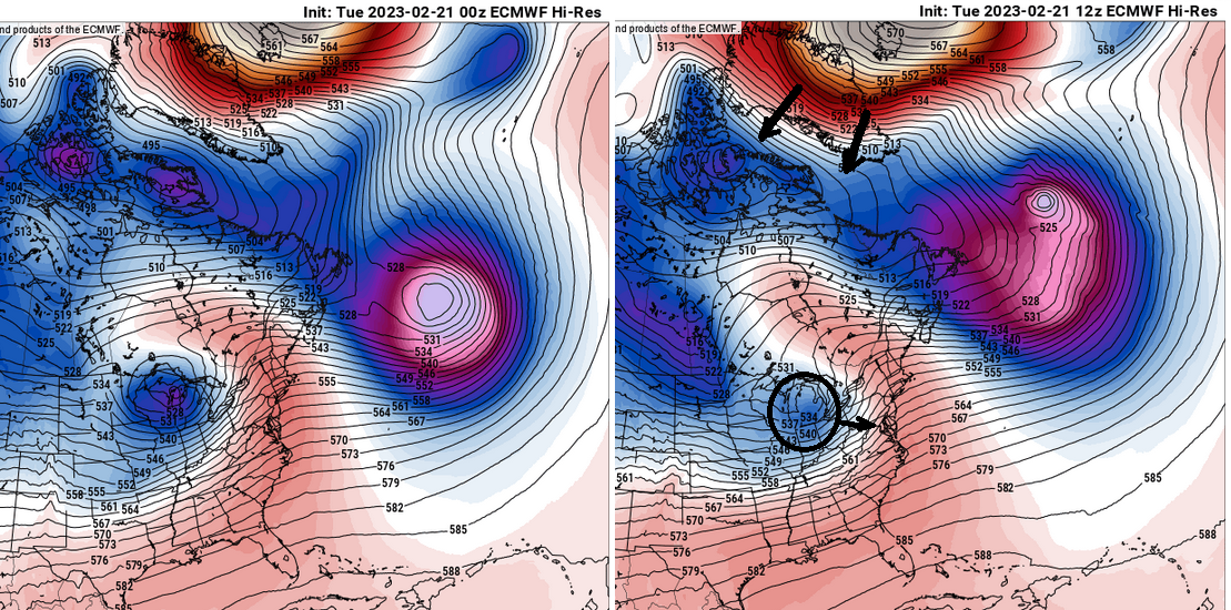
y'allz funny mu'fuggers Actually, this 12z run of the Euro ...I'm telling you, you can see more NAO exertion comparing 156 to the previous 168 ... f ...here that's why this run is better. It's subtle, but you can see how the 12z retros the NAO just a little over the previous cycle ( left ) and immediately ...the hemisphere responds by forcing the Lakes cutter more E. It just takes that little bit of adjusting and it forces the activity here, South. which ( now to confuse you ...) isn't really the NAO forcing it - it gives that allusion. It's really just that these features move as an integral at large scales, or tend to.

-
seldom do I engage in this sort of discussion but .... really? Serious Q: do you like 40 F mist in between 38 F straight rain nor'easters... always relentlessly every day ?
-
I like the appeal outside today though ...least around here. We got the old 'under the radar' grits and flurries going... it's a solid fireplace afternoon. Also, that looks somewhat convective out there in NYS ...wonder if we can't get a burst later this evening