

Typhoon Tip
-
Posts
43,396 -
Joined
-
Last visited
Content Type
Profiles
Blogs
Forums
American Weather
Media Demo
Store
Gallery
Everything posted by Typhoon Tip
-
Models trying to come around to a warm pulse next week - I'm sure it's been noted....
-
Nice fat regional power outage blanketing 4 or 5 towns this morning... to which Ayer was one of them. Apparently some sub-station decide to trip ... or blow up. Who knows. Well...actually, it wasn't a damage thing or else we'd be out for 2 weeks. I read that these substation parts are not stocked? one particular reason why a Carrington Event would be particularly crippling... because A, it would take a long time to fab the parts necessary for each substation that got zapped, and B, because so many of them... it would take years (years!) - per NSA estimates - to restore the grid to any kind of function that we've multi-generationally become inextricable so accustomed to needing - to put it nicely. Jesus... It really does hone two failings about this thing... 1 ... Ironically, despite all that power being distributed across the face of the planet contained within the wholly dependent grid, it is utterly fragile. 2 ... The shear lack of back-up systems ( redundancy ) flop over for what is tantamount to an apocalypse if it truly failed. It was ugly out there. Within 20 minutes, the line at Dunkin pooled out the door, and people were yelling into the store as though the staff was somehow at fault. This is how fast "civility" and order and politeness ... everyday cooperative assumptions begin to break down. It really is a prerequisite to a species that deserves it's own demise, to evolve it to be helpless without an aspect they do not protect. Individual residences and edifice can certainly formulate ways to take themselves off grid when the grid trips... but still... society should long been researching and implementing back up systems - they don't even have to be as distributive as the primary - 'brown supply' the f'n population. Just with enough to run a light and heating element.
-
I'm only moderately impressed by that snow, only because it beats out the local climate signal by so far... But, that's at 7,000+ feet. right? I mean that's impressive but isn't that what happens in the clouds - particularly, a cold trough. It seems like we do this every year as our snow seasons finish off screwing us ... we go out and act all staggered by mountain snow somewhere. I dunno... Something similar to this happened 5 or 6 years ago, when there was a pretty potent wet season then, with slides and valley flooding...even quite a bit of res restoration levels. I mean... I was reading a paper about the expectation that all this isn't really going to help the drought there. The problem is that the terrain west of the Divide over western N/A, is too proficient in channeling melt and fall water before it can get into the sub strata where they need it.
-
does 'WOR' mean to imply 'west of region' ?
-
Nice nape out there. High high "nape index" value. It's only 48 F, but dead calm wind whilst intense sun.
-
Global Average Temperature and the Propagation of Uncertainty
Typhoon Tip replied to bdgwx's topic in Climate Change
I also tend to agree that the preceding E N/A 'warm synoptic burst' was circuited to the warm intrusion in the stratosphere. Whether or not that can ultimately ( and probably so...) linked back to the Pac MJO interference pattern or not, I have noticed in the past that warmth over continents in general tends to precede the advent of SSW's ... -
Global Average Temperature and the Propagation of Uncertainty
Typhoon Tip replied to bdgwx's topic in Climate Change
It wasn't an an extraordinarily prominent event but it definitely behaved in the characteristic downward propagation of the warm intruded mass... The timing also situates well with the advent of blocking later in March that year.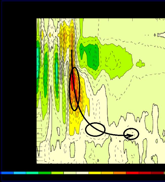
-
Heh
-
Global Average Temperature and the Propagation of Uncertainty
Typhoon Tip replied to bdgwx's topic in Climate Change
While on the subject... " https://phys.org/news/2023-03-deep-ocean-currents-antarctica-collapse.html " interesting little nugget. Ironically... here we're discussing a very similar phenomenon - actually... the exact same phenomenon, but in this case, the polar southern Hemisphere. The 'thermal haline buoyancy' stuff is threatening to shut down that circulation engine down there (haline means the salt content) The way it works is the fresh water flux is lighter than salt water and "floats" over top. Cold salt water sinks...particularly as it cools, and those downward 'chimneys' then pull the surface water back N from the south to compensate for the mass deposition to the ocean depths. ... BUT, here's the key: if there is buoyant fresh water ... effectively 'blocking' that (even in fraction do to turbulent mixing...) that impedes the downward mass. With less mass moving downward, less drag on the surface --> the conveyor system is weakened. Fairly large pallet of consequences loaded up for the canvas of the planetary future with that to put it lightly... -
The bold makes perfect since in a sort of ad hoc assumption... 90% of the "warming" in the Globe and Warming concept has thus far been absorbed by the oceans. Assuming that delta goes back to the Industrial Revolution ... ? - don't quote that. Not sure what the time dependency is wrt to that value, and it matters. It may be more recent ... guess it's short Google work. heh. But if that 90% is say... during this last 40 years of "hockey stick" accelerated(ing) change? Other than being alarming, ...that might also explain why the Ninos have trended warmer over that same span of time. Seems bush arithmetic works. If/when the pattern of sea stressing and wind flux anomalies in the quasi couple marine-atmospheric NINO mode, there is thus more warmth available to that system. Almost seems comically obvious. Except ... It arouses a question in my mind about the "anomaly" comparisons. Are the NINO vs NINA eras strictly based upon historic neutrality of the SS temperatures? Or is there a "relativity" supplied to those calculations. I think that's important, because if the ambient SSTs are ...whatever fractionally warmer than normal, than that may supplement the NINO periods with additional heat that gooses those values. I'm sure with all the PHD's they have working on Global monitoring ...enslaving their red-eyed grad student TA's to do that actual monitoring work... something like that "should" be easily considered but probably is missed LOL. kidding... There was a "Super NINO" over the last 8 years... The actual climate response was rather mediocre, however. There was conjecture in the ambit ...but I don't recall much very in depth research/follow-up on it. But it was like a near historic warm episode that sort of came and went the hemisphere(s) seemed to eat the momentum. Weird. You know ... truth be told ... my cartoon way of reasoning makes me want to think that the 'obviousness' above was in fact missed, and the warmer oceans overall elevated the NINO scalar value, ...not an indication of it's differential to the whole planetary system ...thus it was weaker impact.
-
Global Average Temperature and the Propagation of Uncertainty
Typhoon Tip replied to bdgwx's topic in Climate Change
It would not shock me if future findings hone changes in the total atmospheric circulation mode are at least partially causal related to why the SST warmth has increased from roughly the VA Capes to the D Straight ( relative to those latitudes) ... I'm interested also in the thermocline; sub surface delta and the integrated OHC in those regions, too. There may be concurrent factors. The thermalhaline imbalance causing buoyancy to increase may certainly play a role in/"IF" slowing of the AMO is confirmed. But I also suggest that changes in the winter seasons', sea sfc wind stressing patterns (possibly related to perceived lower frequency of intra seasonal -NAO phase states over recent decades) as playing a role. Less -NAO phase state over the longer mean, means there is more for SE/S return flow tendencies over far eastern N/A and the NW Atlantic Basin ... perhaps suppressing upwelling to some degree. -
no.. .it's unusual... by a significant margin
-
I understand the 'intuitive' thought process behind the question ... however, I'm inclined to think no? See, the physics are just processing input parameters - they are not like "remembering" the old atmosphere in lieu of changing atmospheric chemistry, and then error processing based on where we've been... These are based upon thermodynamic laws operating in a fluid dynamical law defined system. Having said that ... if the chemistry of the medium being modeled changed literally within a guidance cycle outlook frame ( typically two weeks worth of projection), then perhaps the results might bias ( warm)(cold) when then compared to the original outlook from two weeks earlier. However, that can be all but ruled out in this case because the atmospheric constituency gases and so forth are not actually changing at that rate. My personal gripe about this winter was that the models might have been too aggressive with cold boundary layers in the mid and ext ranges ... yes. However, that is likely for origin flaws in other areas of the model's complex construction of counter acting, interfering forces. Digression a bit, but these models have to simultaneously manage in a single process effort, a truly dizzying array of interacting "secondary field mechanics," which in turn, interacting aspects --> emergent properties. That's probably approaching something like incomprehensible to even a polymathic savant. It can't be ruled out to 100% certainty - seldom in nature can 100% of anything be. That's like a theoretical unicorn state. Black holes are only 99.999999999999999 % cut off from the Universe, as Hawking Radiation demonstrates - quantum uncertainty principle allows for spontaneous particle creation in duality pairs, and the escape of one near the even horizon steels energy from the 'hole' ...effectively reducing it's mass by some ungodly small amount. Do that over trillions of years, and BH's evaporate. hahaha... happy now?
-
Global Average Temperature and the Propagation of Uncertainty
Typhoon Tip replied to bdgwx's topic in Climate Change
Yup Bluewave ... aware of the SST paper(s) wrt coastal plain snow increases over the last 20 to 30 years. I was going to mention this but you beat me to it -
But the 'marginal set ups' are ending up warmer, too - Seems the models may be too cold then, perhaps. We know the GFS is anyway.
-
Well... As usual, I was making two points at the same time and probably just being more confusing because of that. I was originally just commenting to PF the idea that our marginal set ups tend to end up more +1.5 as opposed to -1 ... that does seemed to be reproducible. The "warm burst" was a digression - but yup. The recurrence of those - I'll just say personally I don't think that is just noise at this point. Speak of the devil... we'll see, but there's some suggestion that Apr 6 the 10th may bring the goods but conflicting signals there. Not a lot of confidence.
-
Right, they probably didn't have more modernized hvac tech outfitting shoe-string budget municipalities like public school buildings (because we have our civility priorities straight) yet. They had to manually flip out the 'winter system' for the warm season. Ha ha. That might be just fiction, but I've seen that happen before in person, where the heat is still on during unusual warm spells when I was in school up at UML. Not sure that happens so much in this era... things are increasing mini split and controlled by automation. You hapless working class population brats sitting there sweating in 92 F with the windows open - ...not hard to imagine.
-
Oh yeah... shit yeah. It's deltas in different rates of change across multiple factors. He, more like "..a little of ambrosia" Delta climate Delta seasonality Delta pattern Delta model performance ...probably, some smaller amount of Delta fractals and being open minded to randomness, too.
-
Random thought during this cold goo of a morning ... I remember in 1998 ... like it was yesterday as the cliche goes. So vividly, though that juxtaposing the 29th -31st of March that year, to what is out there right now is stunning. I thought that extraordinary stretch of temperatures around the Merrimack Valley up in NE Mass was perhaps a once in a lifetime experience relative to the calendar. AfternoonS above 85 ... one of which poked a hole into the 90s at 91! On March 30 We've gone on to at last "arguably" similar on several occasions since 2008 ... Regardless of ENSO this, solar cyclic that, or propensity to explain it as just noise ( ) ... the recurrence of dramatic early warmth in Feb-Apr makes on wonder if that may just be a climate threshold crossing and is now part of life now.
-
There was some minor "hope" - if we want to call it that .. - in the NAM runs 42 .. 36 hours leading. I saw one run that was 0C isothermal N-W of Boston, with nearly .75" liq eq. But the short game started sneaking temperature back into the column. I saw that and rolled eyes, 'whatever.' I mean in late March? - we can't be adding therms. These late season blue deals need to default neggie, not posi It actually hearkens back ( for me) to that idea that the "flop direction" used to be more dependably cold side when in leading marginal set ups. I remember seeing just about any +1 or +2 cold side QPF envelope in 1995 - 2005 seemed to always wind up blue glories. Now, they are always ending up +2 to +3 instead... Or worse yet, -2C end up +.5 ughers. That could be modeling changes, or NJ climate invasion .. who knows. This late in the year ... mid spring month begins in 3 days... it is also harder to separate lacking seasonal cold issue, from the fact that it was 48 to 62 in sun-soaked earth yesterday, immediately before hand. About as close to 10 on the nape scale as is theoretically possible right around 1:30pm yesterday, when it was 62 and dead calm air under close to 100% cerulean blue sky. Then clouds slabbed in abruptly at five, if anything ...insulating all that rad. It started raining here around 7 ish last evening, and it was still 51 F when that commenced ... Without a dynamic hammer that woulda been hard to do in 1995 for that matter. If the 00z GFS is right ...NNE should get some back side/"upslop" chances over the next two days.
-
It's interesting to see all three major operational models oscillating between shit, cold, shit, cold, shit right through D10 like that.
-
There's dreary ... then somewhere beneath that distinction is the realm of March 28th, 2023
-
Global Average Temperature and the Propagation of Uncertainty
Typhoon Tip replied to bdgwx's topic in Climate Change
LOL ... proof that the 1980s blew pickle dicks -
Global Average Temperature and the Propagation of Uncertainty
Typhoon Tip replied to bdgwx's topic in Climate Change
Not sure I see very much disagreement between y'all - in so far as where it counts... You're both suggesting you need more data, specifically ... as it pertains to validating whether or not declination of snow totaling is now (or not) a dependable delta in Boston's climate. First of all, I wouldn't use Logan as a proxy in that. Too much oceanic interference - or in the least, the proximity to the ocean would need to be ruled out somehow geo-physically/statistically as a contaminated data series. Probably, use the triangular method: HFD-CON-ALB. Then perhaps do a separate region that is bounded by BED-PVD-ORH. Reanalysis techniques may also speed some of that up... however, I would aver at this time that if anything, the snow should be increasing, until such time as a "threshold" is breached. It's unclear that 8 years of anything in climate means very much. If we go by that scale, the 1970s would have us staring up the fascia of a 1/2 mi high ice sheet by now - kidding... That all said, the threshold idea ( which IS veracious, unfortunately) means that it may not take 50-100 years. It may not take 20 years for that matter.... or 10 or 5... That's the point. Particularly if it's a silent boundary, like going through an Event Horizon - you may not noticing anything particularly out of the ordinary going over a threshold. Again... you just sort of wake up one day and realize you're not going back. What has me a little spooked is that the climate modeling is already behind the rapidity of noted changes, so theoretical thresholds are closer than thought would be as recent as the projections from 20 years ago. See... don't look at the 1.5C since the Industrial Revolution. Decimals in that average are not linearly, or symmetrically distributed across the face of the planet, nor is the affect of CC. -
Global Average Temperature and the Propagation of Uncertainty
Typhoon Tip replied to bdgwx's topic in Climate Change
The issue that immediately jumps to mind for me when I hear or read these answers to the question of snow vs CC over eastern N/A ... they appear to assume a linearity, and/or symmetric result and that's philosophically dubious to me. The forced circulation of the planetary body of atmospheric responses do not typically motivate as a linear 1::1 cause to effect, at all temporal scales and spatial sizes - the latter of course being slower by simple momentum arithmetic and Newtonian dynamics. and so on Perhaps a way of backing into that realization? - considering "thresholds" (as a verb) phenomenon. These abstract virtual boundaries in how the systems respond to forcing in nature appear to take place once compensating stabilization means, in situ, are finally overcome. An "elasticity" or bounding event or series, resets a location into a new paradigm - in this sense ...we are talking about climate. There's a reason that scientific circles accept the vernacular, "nearing thresholds..." etc.. A purely linear/ and symmetric, or coupled causality to observed results, would not suffer threshold phenomenon. A linear atmospheric systemic response, to which climate describes, would move concertedly with the advent of the new forcing. Thresholds, on the other hand, are an acceleration. That's not a straight line in simpler terms. We cannot logically assume, given that reality, that raising the temperature 1.5C since the Industrial Revolution --> x-y-z, having snow results so far = a-b-c, will continue along that linear projection. It is more likely ...at some point along this journey... either knowing it is happening, or unwittingly we all just realize, we've ended up on the other side of the virtual boundary (threshold). Some thresholds are crossed silently. Some would argue that much of eastern SNE is already much more NJ -like, just by anecdotal accounting. Which obviously that is far less than the consilient findings of the scientific ambit. It's still fun to relate this morass to the common everyday life, though - otherwise why the f are we doing this thing called humanity ( other than unwittingly forcing a "Fermi boundary event" )


