

Typhoon Tip
-
Posts
43,386 -
Joined
-
Last visited
Content Type
Profiles
Blogs
Forums
American Weather
Media Demo
Store
Gallery
Everything posted by Typhoon Tip
-
It’s too early to be specific, of course, but just for fun… The Canadian solution underscore what I was saying early about the sneaky wind potential. There could be like a 2 to 3 hour period there east of Worcester over coastal southern New England where they get battered pretty good with wind gusts and sideways snow in that solution
-
Meant to respond a Tauntin’ ha ha ha
-
You guys seem to respond to whatever image you’re seeing with no larger perspective. Weird It’s an encouraging GFS run for obvious trend potential/reasons
-
That’s not the take away… The take away is that it’s in flux man.
-
Huge changes in the total synoptic handily across the continent with regard to the 10th on this GFS run
-
Previous run was better by 10% or something
-
This may have a sneaky wind issue for the Massachusetts coast and along the Long Island sound. There’s just enough pressure well there and up against that high-pressure over Quebec …there’s gonna be a decent gradient there.
-
Anchoring high pressure like that is something we haven’t seen in years.
-
Interesting … seemed to start out that way but ended up the same
-
Looks N of previous
-
Bears no likeness to the others
-
Above all else ... right. Nice to have a "Fantasy Warning" issued LOL... We'll see how it goes. Frankly, I'm not particularly fond of any of these events to be honest. But my concerns aren't surrounding p-type. The telecons are going the wrong way from multiple sources. That's A. In fact, the textbook interpretation has each one of these losing that support in successive order, heh. Yet the operational runs have there magnitudes in the opposite order. It is what it is I guess. B, this is my own supposition so tfwiw: model amplitude bias may shock some as the scale of these come into nearer terms and we lose some 20 .. 40% of their magnitude. The speed of the flow tends to be slowed by guidance, and speeds up from D 9 to D 4. The speed up takes storm mechanical energy away and give it back to the baseline velocity anomaly. This is an aspect I've noticed since ...2010 really, about winters. The core months get speed saturated and we see this energy exchange. All the models do this... Yes, I think I'm the only one that notices this kind of excruciating detail because I have no life. But this why systems tend (not always) to be weaker when they come through that D4.5 model performance window.
-
I agree ... this storm in the Euro has the option of containing a broadly expansive mix region, with snow to start going over to a rattling off the eaves and bouncing down windshields. Freezing an option too but more likely a tall IP column. Could see the interior with IP clumps even at 25 F. That high will likely tank the hydrostatic hgts below the 700 mb level though. I'm saying this just purely because there is unusually ( what's new ) warm air south of the storm track, while the 500 mb trough isohypses remain open while the trough bodily passes NW of the region. A 700 mb warm intrusion isn't a bad idea here. it is not abundantly clear that the exertion/rearranging of the -NAO ( be grateful it's western limb or we could be cooked with NY state transit), but if that begins to exert during the week and the 500 mb squeezes more S than we ... there's time for that too -
-
This could be a rattler. There’s room for this to correct north, but I also think that it’s going to run into a cold wall… In no small part related to what we were talking about yesterday with the falling polar field indices beginning to exert on the field, but more practical terms you’ve got cold surface high situated nearly ideally to the north - flipside of the same coin. Might create a broad mix zone.
-
I frankly like the GEFs being slightly progressive at this range because it fits that model system’s bias heredity
-
Yeah agreed mention that yesterday… Had a midwinter tornado outbreak look in that GFS run yesterday so not surprising here. If this weird long wave stretching shit continues to play it’s going to end up causing tremendous sheer/instability cross up down there.
-
Don't be surprised if the 7th entity ends up like the 4th as we get closer to that date, too.
-
I can imagine that sentiment would be shared among the local faithful. ha
-
That would probably be a Cleveland exit into eastern Canada in that look.
-
What I suspect is going on here in driving the current sensitivity is a bit theoretically challenging ... But, the numerical telecon say no way on siggy storms E of 90 W. We really should be seeing the evolution of a 'thaw' climo/ridge. I think what's happening is a compensating for the former, by surplus speed of the flow. It's mechanically stretching the -PNA configuration causing an exceptionally broad ( 'REAL') Rossby wave length. So broad that it almost "clicks" the mode around. That's typically a very unstable wave length. I believe if the flow were to ease off the throttle, the wave length shortens a little and the actual N/A pattern structure would then look more -PNA correlative. You don't typically have positive geopotential height anomalies NE of Hawaii and have negative height nadir so deep through the Lakes region - that's out of phase. I guess I am saying all this because, these storms are not really supported by theoretical spatial/synoptic meteorology, rather appear to made from the idiosyncratic nature of that unusual flow structure above. It doesn't lend to confidence in general.
-
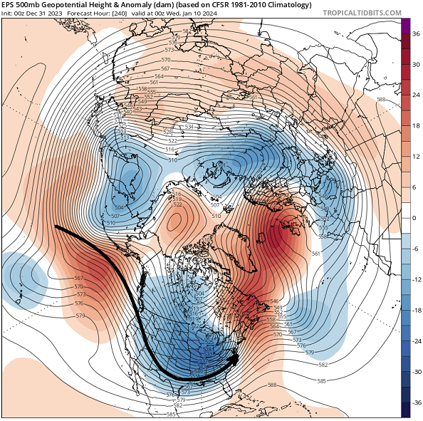
Stepping outside the sandbox for a moment ( ... or maybe 'litter box' is apropos ), this EPS mean looks like March 1993. Triple stream phased planetary low event:
-
We've basically covered all that, already. It's nice to cite NWS I guess ...
-
Hey Will ... if you're lurking, do you have that PSU link for the historical model runs? I seem to have lost that. I'm keen on this Jan 7 thing because in reminds me ( in the general mid latitude circulation manifold) of the Dec 2005 10. NCEP's map library has the chart but it's the 12z only and I was wanting to see it closer to the 00z - I think your site has those?
-
It's a sensitive 10 days with potential for significant error - exceeding the base-line 'error climate' for modeling. After about 5 days from now ... the EPO flips positive, as the PNA sinks to -1 or -1.5 SD; meanwhile there is a continued general consensus for -AO/-NAO to anchor N/E. Those two are diametric signals occurring at hemispheric scale. Small variances from run to run are actually large changes in both time and space with entities at smaller scales. What you're describing is like a small back-off of the -PNA, but so subtle it barely registers in the numerical calculation of the index; yet look at the strife it caused during yesterday's model runs? It's kind of a big deal whether PIT-BOS line gets 36" from 3 separate events, or nada. That larger of all signals near the 11th has shifted E from the Iowa 'anchor low' idea, now more of a progressive season defining bomb for the Great Lakes, but I would not trust that. 18z yesterday, the operational GFS had that completely forced E and now it is wind blown open busted ravioli nuisance up through Minnesota again. It's something like the models are right about the entities existing, but there's some enhanced position error on where they will be - because there is no real boundary or exact interface where the circulation mode of the Pacific ( described above, which is a warm Chinook signal for N/A) approaches and begins to experience constraints imposed by the -AO/-NAO. Which is of course a cold, blocky storm thing... completely different universe of expectation.
-
I’m not sure why … and I’m not saying things are gonna work out this way, but for some reason all evening, I knew these model runs were gonna look this way tonight. Don’t ask me how I knew I just had a feeling like I didn’t wanna even look. I guess it’s good for the mid Atlantic snow for at least one of them.


