

Typhoon Tip
-
Posts
43,369 -
Joined
-
Last visited
Content Type
Profiles
Blogs
Forums
American Weather
Media Demo
Store
Gallery
Everything posted by Typhoon Tip
-
It was a Flop... February 2024 Disco. Thread
Typhoon Tip replied to Prismshine Productions's topic in New England
Yup 20th -
It's actually the weak S/W and attendant back side flow going normal to the hydrostatic gradient ( i.e., CAA) ... which scoots by overnight Saturday night - while not a huge deal, it is crucial and starts that process ... The advent of 'sneaky' cold advection 30 ... 36 hours prior to arrive disturbances is quite highly correlated - for those that don't know to look for that
-
It was a Flop... February 2024 Disco. Thread
Typhoon Tip replied to Prismshine Productions's topic in New England
I mean the mid level jet mechanics are approaching upper bound material with wind exceeding 130 kts at 500 in a jet tube that spans WI to S of LI. wtf -
It was a Flop... February 2024 Disco. Thread
Typhoon Tip replied to Prismshine Productions's topic in New England
Okay, ... a gift for Scott, Ray and Kevin Today marks the first day removed having exited the perennial solar minimum, after spending 91.25 days since Nov 8, in the cave of winter This is now the solar transition where moving forward the +delta in daily irradiance begins the equinox acceleration. yay! -
It was a Flop... February 2024 Disco. Thread
Typhoon Tip replied to Prismshine Productions's topic in New England
agreed ... the 20th may be the next in the hemispheric cycle - I realize that's the 23rd but I suspect it's all within shuffling range, either way -
I don't normally make comments of this nature but ... can we lose the mustache ?
-
Despite all peregrinations ... enough similarities to make us ponder how much the patterns really changed...
-
It was a Flop... February 2024 Disco. Thread
Typhoon Tip replied to Prismshine Productions's topic in New England
The cold should be expected, though. There's a very strong -EPO signal from every telecon source that's been in the projections for over a week, positioned between ~ the 13th and the 20th... 7 days of cold loading into the Canadian shield still on the polar side of the Equinox probably not a warm look along the NP-GL-NE garland. -
It was a Flop... February 2024 Disco. Thread
Typhoon Tip replied to Prismshine Productions's topic in New England
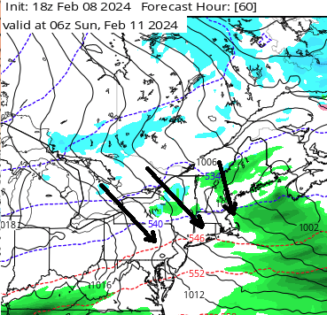
I know - did you see the 12z Euro ? gelid hell. It creates a standing R- wave that happens to place a continental cold conveyor axis right through New England ... sub 520 dm non hydrostatic hgts in a laminar sort of 40 mph wind -
It was a Flop... February 2024 Disco. Thread
Typhoon Tip replied to Prismshine Productions's topic in New England
Okay... lol - if you need to go there, that's fine too. Not sure why but okay - -
It was a Flop... February 2024 Disco. Thread
Typhoon Tip replied to Prismshine Productions's topic in New England
I got news for ya ... you're in spring. These cold outlooks since ... maybe 15 years ago but more so recently, are behaving more and more so like spring cold snaps. A qualitative appeal that too few are really aware of, either because they don't want to be, .. or it simply hasn't occurred to them. And guess what? It snows in spring sometimes. -
talk about a strand of thread along the axis of a needle ... the whole f'n storm is like 50 mi wide
-
oh, I know You know frankly it gets harder and harder for me to think that CC isn't effecting the way the circulation of the planet behaves and somehow it is having some sort of effect in the physics - it wouldn't be a violation idiocy like some think. I mean they're just ill-equipped now in the sense that their defaulting to missing needed components to keep up. Maybe when Quantum Computing comes on line - that's a whole 'nother terrifying reality for this engagement because let's get honest ... much of the allure is in the mystery of the unknown. I don't know but ever since the atmosphere began speeding up ( and there are papers that directly demo now how CC has in fact made that happened - thanks ) I've noticed that we've slipped performance in the mid range by some
-
but, we should have additional opportunities beyond this one ... hell, maybe we can help the Feb 15 to Mar 1 W-L column because that period of time has a relative nadir in historical activity.
-
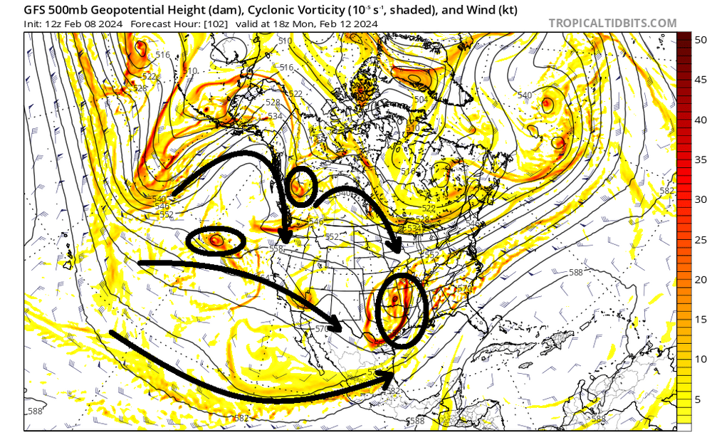
M'yeah the more I look at this ... the more I'm seeing the origin of problems over more vs less phasing potential is actually coming from the transitive influence of the E. Pac flow relay. It's sending negative interference downstream during present era of modeling cycle trends. Not saying it goes on to be the final... I've seen these things correct from this range. unknown. But that's it, no question. So this is more of a scaffolding of the entire flow structure, at continental/hemipheric scale issue. We are simply not generating enough of a R-wave ridge signature over western N/A .. under cutting the -EPO ridge (speaking to the operational's handling) is bad in this case. This below ? Is a piece of utter shit ... very little/zero means to force wave space coalescence down stream
-
You know dude... what's happening there ( imho ) is that the ridging over the Pac NW/B.C. region is actually growing, but doing so at the same rate as the N/stream S/W is actually attenuating in time. It's like we're creating the scaffolding for a better phase result, but the N/stream S/W relay from ...where ever that is originating being weaker and weaker, there's no diving wind max enough to "take advantage of it".
-
It was a Flop... February 2024 Disco. Thread
Typhoon Tip replied to Prismshine Productions's topic in New England
well .. yeah .. fits the CC modeling - the variability was always hit hard in what even the primitive models always put out. Now we're living it and going 'what the f is all this short term variability' ... humans are an interesting walking talking diametric super position of utter genius and astounding beauty at the same quantum space and time of cartoon stupidity and hideously disregard-able personal ugliness' -
Yeah, for me the greater experimentation value is/was the verification of a storm on the index inflection - 13th is the steepest part of the graphical projections from the big three. That much seems fine at this point. The snow vs rain and where ... how much? Jesus Christ. Tele's say batten down the hatches. The operational runs are windshield wiper events at times even dim sunners. heh it may turn out the only major impact is the pain the neck this caused? Who knows. There is some availability to a colder solution though. I outlined this earlier, but I'm not actually too put out by these warm GGEM type washes... they're likely both deep layer wrong, and then also considering the native model bias ...etc of some of these tools to be warm BLs. I'm more intrigued in whether we hit the key-hole lat/lon because there's marginal but enough cold to make due if we can hit that. It's not impossible just yet that we do or don't either way. All the while, this thing has back ground arguments for being way more impressive anyway - that part's a separate frustration. If it got more amped and N/streamy-like ... no question to me that someone gets pretty damn white -
-
Yeah I've been more than less crooning that aspect for a few days, actually. The operational runs across the board are to varying degrees, not representative of the index calculations that originate from their own ens systems. It's weird. You know ( ...risking poking the hornet's nest here - ), if this corrected suddenly way more amped in the last 72 hours because the western N/A ridge is suddenly more represented and that triggers an N/stream canonical dive through MN ( like the GF-f'um S actually had two nights ago for f-sake), I would not be surprised. But it may not... you know, one sore rub about this stuff is that anomalies relative to the larger ongoing anomaly, do sometimes take place. But your right as rain on that look there. That's like a straight up zonal progressive rake by the operational run that is almost diametric to the principle of a increasing meridian flow associated with said ens derived index handling. Interesting. It's not just the GFS doing this though. All the other operational models appears to be guilty of this to some degree more coherent or less. They're all shirky looking- GFS is just most egregious as of late.
-
Fwiw, the Euro and UK are a better fit for the +d(PNA). In fact ... there's only been a couple model cycles out of the last several day's worth that really fit the general index manifold This entire erstwhile handling has been rather depressingly conserved. Always on the low-end representation of the correlation. I wonder if the EPS is attempting, though. .. I see the 0z mean with a sub 988 at D5.5 pretty well nucleated to the the proper climate location; and it still has those spread members indicating bomb depths or close to it. Not sure if some of those individual members have more N/stream involvement but probably. The 00z Euro operational was the best current compromised solution between the index argument, vs the lack-representation in the guidance. A low in the process of deepening below 985 mb while sliding under L.I. in route to just SE of ACK, with the 850 mb isotherms S of PVD ... Boy, the index imply a major - if only.
-
It was a Flop... February 2024 Disco. Thread
Typhoon Tip replied to Prismshine Productions's topic in New England
So it’s official then… This is officially a worse stretch than the 1980s. That is …. incredible LOL -
It’s kind of the unmanned fire hose


