

Typhoon Tip
-
Posts
43,368 -
Joined
-
Last visited
Content Type
Profiles
Blogs
Forums
American Weather
Media Demo
Store
Gallery
Everything posted by Typhoon Tip
-
May 2024 Discussion - Welcome to Severe Season!!!!
Typhoon Tip replied to weatherwiz's topic in New England
NW massachusetts is sunny-ish .. The western side of this convergence axis is winning this thing now, as there's a definitive clearing line out there pressing E. Hang on folks, there's an end to this madness. The llvs will persist with the east shits through tomorrow as the seldom understood reality about SNE, being that we are decoupled from the rest of the planetary atmosphere ( jesus!) was clearly created by an asshole god on purpose. Heh eventually that yields from the top down tho. Monday's surface ridge settles finally E enough to veer the winds around... Tomorrow and Monday will be two different worlds for folks E of ORH -
May 2024 Discussion - Welcome to Severe Season!!!!
Typhoon Tip replied to weatherwiz's topic in New England
It's actually perfect to me ... it fits right in timing with my personal pattern. heh. Not a work out day. No yard projects going on. No other plans? I guess if we have to douche out a whole day, this would have been the day I picked. -
May 2024 Discussion - Welcome to Severe Season!!!!
Typhoon Tip replied to weatherwiz's topic in New England
Hey John .. low grade heat wave potential, Tue-Thur. By that we mean ... flirting with the big nine-O but could miss with upper 88's. I don't see this as being a dewy heat - we'll see on that... Wet antecedence may contribute locally more so than transport with higher soil moisture after recent rains. But, the current machine numbers are likely a shade cool given the over-arcing synoptic look there. -
May 2024 Discussion - Welcome to Severe Season!!!!
Typhoon Tip replied to weatherwiz's topic in New England
There's also some straight up convergence between about HFD and ASH ( axis ). Look at the region sat loop you get a distinct impression of a general westward motion east of that line, and an eastward motion west of it. Where in fact if Kevin drove 30 minutes west he'd be in brightening. I think western CT is trying to salvage the afternoon. https://weather.cod.edu/satrad/?parms=subregional-New_England-02-24-0-100-1&checked=map&colorbar=undefined -
May 2024 Discussion - Welcome to Severe Season!!!!
Typhoon Tip replied to weatherwiz's topic in New England
Well ...anyway, back here in reality ... That's starting to look more and more like a low-grade heat wave potential Tue-Wed-Thur. The 2-m products ( which are a joke, because they don't in fact actually ever represent the 2-meter slope temperature, but appear to stop/interpret the sfc as the 1000 mb level on the bottom of the soundings ) from the operational runs are already 85 to 87 on Tuesday and Wednesday... 850s are marginal though. 14 to 16C ... but that appears to coincide with favorably less ceiling/blocked insolation, all happening over a wind trajectory that is transporting a kinetically elevated air mass. This has been sort of in the making for over a week in the telecon spreads, with a pretty strong -PNA. It seems to be finally over powering this weird trainwreck thing we've been observing for the past week between here and lower D. Straight. The NAO hasn't been hugely negative ...just sort of. It seems some other emergence of the larger scoped synoptics is/has caused this semi-permanent grunge stalling in in the area... Anyway, 88 to 91 wouldn't shock me for those two days with Thursday a bit sketchy because a Pac front/convection my break the party at that time. And the upshot of this analysis is that I actually studied the guidance when drafting these projections ... -
May 2024 Discussion - Welcome to Severe Season!!!!
Typhoon Tip replied to weatherwiz's topic in New England
WTF ... I just bold' right back to you, what you posted about NWS SO yeah, I did - 'showers are possible at any time' you seem to also be blind to content that proves, in objective clad black and white facts, your BS - I forgot to add that charm to that list of your accolades - -
May 2024 Discussion - Welcome to Severe Season!!!!
Typhoon Tip replied to weatherwiz's topic in New England
Ha ha ha to say nothing of the fact that Dendrite only must somehow be construed as a positive thing when it comes to turd weather - -
May 2024 Discussion - Welcome to Severe Season!!!!
Typhoon Tip replied to weatherwiz's topic in New England
You need reality scope checks ... badly. First of all, in interpreting Met discussions ... that bold statement counts. It was possible to do what it is doing. That does not mean, mainly dry in concept or intent - neither. There's thinking positive' but you have to do it from a position of objective plausibility - not just because it is what one wants. Lol. Secondly, "the 18z runs" don't mean jack shit when there's run after run after run signifying something else when taking their ( duh ) aggregated mean. But ... just for shits 'n' giggles, that is not true about the 18z runs, yesterday, anyway, when taking that single run cycle in a vacuum: Like I said, as this series ( 18z run yesterday ) clearly shows... the GFS busted but the other guidance has QPF plugging into the region from just about exactly what you see happening in the now-cast/synoptics at this time. Bravo all guidance except the GFS. See... (this goes without saying at this point) ... you don't actually look at the guidance. I think you sometimes gather what the guidance must "seem" like just based on something like ... I dunno, the mood-tenor of the moment from the shenanigans in here. That's a social awareness - I'll give that. But it is exceedingly error prone in the long run and gets you into trouble, because you make statements that are patently incorrect, like, "At 18z models were mainly dry... " It's all good though... you're the class clown. They serve a purpose too -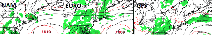
-
May 2024 Discussion - Welcome to Severe Season!!!!
Typhoon Tip replied to weatherwiz's topic in New England
Every guidance except the GFS had it - made a point of it yesterday. The GFS busted fwiw to you -
May 2024 Discussion - Welcome to Severe Season!!!!
Typhoon Tip replied to weatherwiz's topic in New England
Huh? Radar shows light rain approaching HFD now -
May 2024 Discussion - Welcome to Severe Season!!!!
Typhoon Tip replied to weatherwiz's topic in New England
Interesting little short term battle between the this new 18z GFS vs everything else for SNE for tomorrow. GFS is gray but dry...probably a little milder by virtue of being so. Perhaps a little drizzle on the immediate shore points. Maybe some breaks in ceiling out CT and western MA. everything else squares the day into the dumpster with steady light rain shut in weather. -
May 2024 Discussion - Welcome to Severe Season!!!!
Typhoon Tip replied to weatherwiz's topic in New England
It's become a phenotype of Mays to have BTV smoke NYC and BOS' batting average for warmth lol Although next weeks looks like a I-95 corridor warm special from D.C. to PWM Wed/Thur - -
May 2024 Discussion - Welcome to Severe Season!!!!
Typhoon Tip replied to weatherwiz's topic in New England
It may not rain 'up here' though, ... much. I mean drizzle passing here and there but primarily dry. There's no real means to provide lift, and most likely where the models have the stationary very light QPF blob parked over eastern zones that's just the land/sea convergence over sensitive in the runs. It may also start to sag south during the afternoon. Sort of like what happened yesterday. It'll be a cooler air mass everywhere though. It's a matter of how much. -
May 2024 Discussion - Welcome to Severe Season!!!!
Typhoon Tip replied to weatherwiz's topic in New England
Yeah unfortunately ...tomorrow probably is 15 below today ( tick or two ). It's probably a day where Danbury CT is bathing in a utopia while Beverley MA is having second thoughts of ever having placed a town charter in that location. -
May 2024 Discussion - Welcome to Severe Season!!!!
Typhoon Tip replied to weatherwiz's topic in New England
All seriousness ... ( and tedium ), it's a nice out there today. 70 here. I'm noticing that the CU trajectory and the llw wind is actually more NE were I am here in N . Middlesex in east central Mass. That's technically not a marine flow here. With sat presentation showing only micro fluffies getting in the way of the sun, we're probably going to be just fine this mid day. Maybe the s-breeze mechanics overwhelm late in the day. I also noticed the 12z NAM is a little better for Sunday. It's probably going to be cooler coast, warmer deep interior type thing. Could see that being 63 here and 53 at Logan. ...75 in ALB. With sun around. That's a better scenario than prior run. -
May 2024 Discussion - Welcome to Severe Season!!!!
Typhoon Tip replied to weatherwiz's topic in New England
Fixed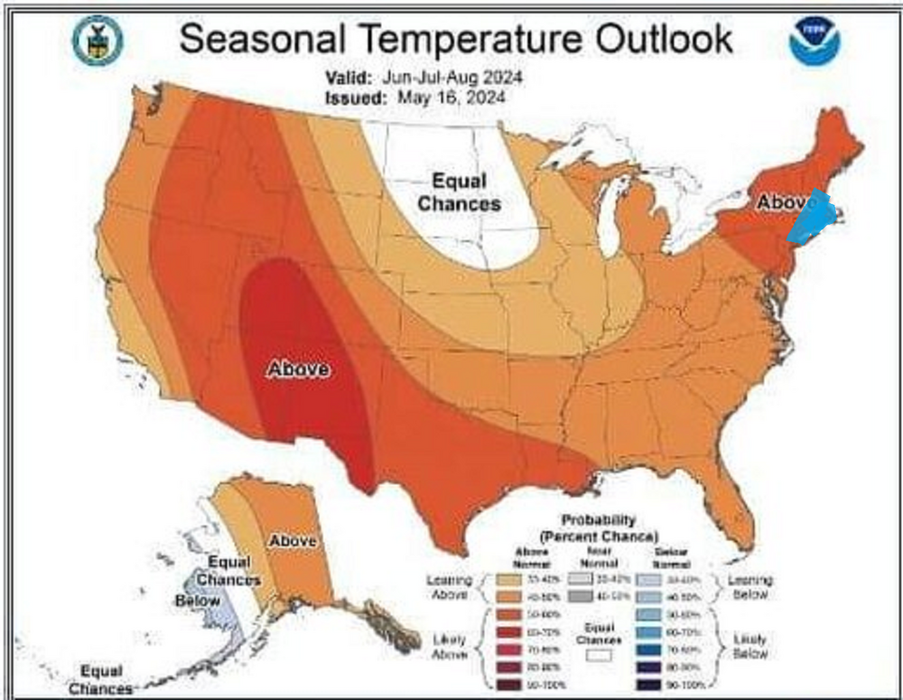
-
May 2024 Discussion - Welcome to Severe Season!!!!
Typhoon Tip replied to weatherwiz's topic in New England
It's almost like the GFS' physics cause these analogous 'Jovian' like fixed spots. Vortex modes, and the rest of the atmosphere just starts moving around them. We happen to be stuck with one SE of L.I. ... Not saying its even wrong, necessarily. There's currently a festering llv gunk low there this morning, helping to send <700mb slab back west into the region. It seems to be all but entirely uncoupled to the mid and upper air synoptics. Something about the llv mass field circulation medium is forcing that interesting -
May 2024 Discussion - Welcome to Severe Season!!!!
Typhoon Tip replied to weatherwiz's topic in New England
That's a bit different circumstance, though. The Euro I was using to commiserate was D8.5 This above is typical of the GFS at that range. ... just humoring a 372 hour chart for a moment... It seems like a transfixed result of the model, where out around further ranges it (perhaps) loses all other driving forcing ... allowing the underlying Labrodorian cold climate sink as an actual atmospheric footprint. I mean really, just imagine for a moment we remove the land from the map, that's indistinguishable from a the Labrador current's cold SST termination waters. Which by the way, that depiction is colder than the current, too. It would have a cold offset regardless of its own rancid low. ( That latter fact sometimes makes me wonder if it is exposing some of the modeling strategy at NCEP where they may in fact be initializing grids based on climate. The Lab current has been notably getting warmer in the last 10 years in particular ...etc. ) Not just with that aspect. I've noticed the GFS is the wrong model - always - to ever detect heat at extended leads. It's like they templated the model to hide CC LOL ( little sarcasm there..) -
May 2024 Discussion - Welcome to Severe Season!!!!
Typhoon Tip replied to weatherwiz's topic in New England
Nothing like a deep coastal nor'easter while the rest of the planet undoubtedly puts up another hottest month ever - -
May 2024 Discussion - Welcome to Severe Season!!!!
Typhoon Tip replied to weatherwiz's topic in New England
Frankly it looks like all models were festering that low level grunge low E of NJ, while S of modest +PP layout over NS - hold just enough differential static for 2 days it sends pulses of low level Labradorian ass vomit all weekend long. I'm like ... really - They weren't ever ideal for the weekend in prior runs, but they're coalescing around that idea now doesn't seem like physics. LOL. And this is infuriating looking ... because it's hard to find any kind of mid and upper support for that "anchor" low. And it's not even deep. It's like 1009 mb ... barely lower than standard sea-level, yet it keeps us in the 50s ... I gotta say though, we were supposed to be locked in the 50s in the 2-meter progs from the Euro, yesterday, yet we had a gorgeous sunny mid to late afternoon into early evening and temps recovered to 70 for a high. It's probably grasping for hope to say so but it could be a prelude to these models over doing it. It's really sensitive around here.... the ocean being 44 F while the 850s over land support 72 makes for some whiplash error potential. All depends which 10 minutes of W or E wind is in place. -
May 2024 Discussion - Welcome to Severe Season!!!!
Typhoon Tip replied to weatherwiz's topic in New England
I'm getting an estimate at the end of the month. It's not just about the installation. That too, but mostly it's about a fraction of the per annum energy cost to heat and cool the edifice of the home. Plus the sound controls. Jesus. Install A.C.s that don't sound like an emissions control test at an aeronautical proving ground cost a lot, plus are less efficient to even run. In the winter, my house has electric base board heaters. redic -
May 2024 Discussion - Welcome to Severe Season!!!!
Typhoon Tip replied to weatherwiz's topic in New England
low/non-zero probability for 89.5 type heat wave -
May 2024 Discussion - Welcome to Severe Season!!!!
Typhoon Tip replied to weatherwiz's topic in New England
Sky's lightened some here... looks like dim sun is cleaving through the easterly anomaly across southern NH just to my N. Probably that opens up as the initiation of this thing breaking down. It'll take the day down near the Pike and S.. but maybe some improvements along Rt 2 and N during the afternoon -
May 2024 Discussion - Welcome to Severe Season!!!!
Typhoon Tip replied to weatherwiz's topic in New England
Oh no way. I grew up meteorologically in the 1990s, when the models were amazing compared to the 1980s... By present era standards? the 1990s are neolithic. We were taught in advancing dynamics ....back when the dinosaurs roamed ... that there is a 'predictive horizon' to this modeling tech. It's basically just where the statistical results fall below significance to the purpose. It was, at the time... still beyond the technology of the 1990s, which really couldn't see very well enough to matter beyond 5 or 6 days ( although there were rare times when extraordinary events would show up at D10 and stick ). By today's standards, that horizon has been pushed out D8 or 9 ('m not sure what these horizon values are in use-case; I'm just using these numbers as examples). These D8 .. 9 are somewhat more reliability when combining huge advancements of computing speeds, increased input data density, with other key metrics - to mention also experience. You can increase the odds of success in that range by some 20 or 30% - where in 1995 D7 had 5% ... now has a 25% ..etc There is however a kind of 'absolute predictive horizon,' a temporal boundary whence the inevitable collection of random permutations aggregates too much reciprocating influence, and the system's coherency gets irrecoverably effected. It's an unintended consequence of all complex systems in nature - systems are ultimately not allowed by nature to remain in stasis. There is always drift - just a matter of how much so, and when... I mean, where do we think cancer comes from ? You know, it's an arresting momentum to be informed by ones doctor, 'Did you know that all human males WILL end up with prostate cancer, period. It's just a matter of whether they out live the inevitability.' This is really true for all cancers - more generic to say ... true for all complex systems to flounder. In the context of cancer, genetic mutation from billions of RNA sequencing and re-combinatory mechanics. It's a matter of time. Chaos as a product of time and opportunity cannot be avoided. In weather modeling, it's two process of spontaneous emergence: the models have to deal with their own, yet the atmosphere they model is also emergent. Those emergence' are mutually exclusive. That widens the gap further. Ultimately it doesn't matter how dense the input grid and the speed that is available in order to crunch all that data - emergence of randomness in time is a factor that will always corrupt an outlook. We're probably still not quite there even in 2024. But we are more than a hair better than we were in 1994. We ultimately can't sample every quantum state of every quantum point, simultaneously, with exacting precision - that is intrinsically impossible, as Heisenberg ..et al showed us both mathematically, and empirically that is demonstrated to be the case. You know, the more precise the measurement, you start gaining uncertainty - it's not altogether very intuitive for most. But really, all of nature and reality itself is a result of probabilities. Imagine where we'll be when AI ( and there's a new coining expression called Super AI - think next gen(s) ) is sistered to practicum quantum computing cores? I think the absolute horizon is "probably" found there. -
May 2024 Discussion - Welcome to Severe Season!!!!
Typhoon Tip replied to weatherwiz's topic in New England
It kinda 'suggests' that the GFS, with its apparent hypersensitivity in creating/emerging all these gnats and rogue perforations that undermine ridging ... yeah, it's probably too sensitive, but the physics 'sensing' this sort of oddities - this is one of those perforations. It's not completely useless in that sense.


