Typhoon Tip
-
Posts
43,367 -
Joined
-
Last visited
Content Type
Profiles
Blogs
Forums
American Weather
Media Demo
Store
Gallery
Everything posted by Typhoon Tip
-
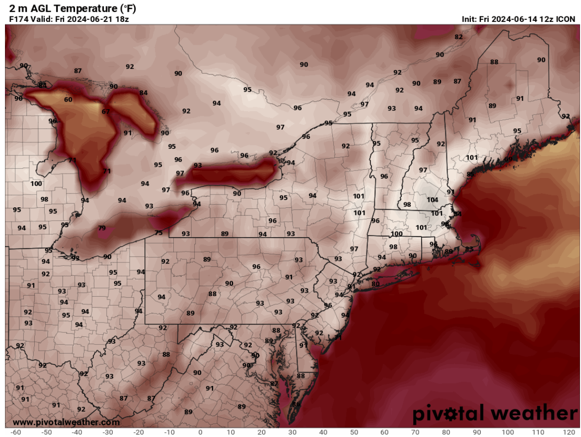
wow, this ICON run is nuts! 95 pervasive Tuesday is a cool bargain for what's in the mail the rest of the week. 99, maxing 102 on Friday... The model only runs out to 180 hours, but at 174 (18z this next Friday) there is no evidence of any kind of synoptic mechanism to diminish the heat heading into the weekend.

-
Mm ..this isn't ten days away, though. Just sayn' I get what you mean and agree in principle, but we're also getting multi guidance support now for 101's out of a D6 lead. Of course, you said "WELL into the 100s" which qualifying that remark ...hovering around 99.5 falls a bit short. heh
-
it's interesting that the highest heat lags the 500mb amplitude in the Euro. The 596+ dm is gone and it keeps getting hotter for the mid Atlantic. It relieves SNE (NE of HFD) but then again, this thing is long enough that the front of it is high confidence and the end of it is beyond the confidence horizon.
-
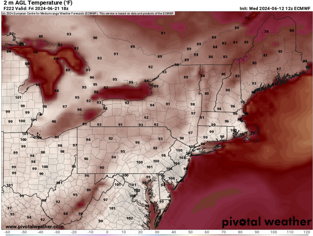
GFS: I was shocked to see 4 consecutive 20Z afternoon readings between Tuesday and Friday, in the 98 and 102 range between PWM to NYC. Whether we set daily records or not ... just off the top of the head I believe that would be a record in aggregation. Euro: While similar in length, it only has two days of triple digit heat, Thurs and Friday. The absolutely sick/'synergistic' heat explosion takes place in the mid Atlantic next weekend, two days, back to back with historic highs - a period of time when the GFS is attempting to dismantle the pattern. GGEM: was 91 to 95 (seasonal) heat wave implication. Similar to the GFS, it snaps the heat rather abruptly with a N-door type front. I just would advise ...the onset of this heat excursion is higher confidence wrt the pattern orientation, while just middling confidence as to actual high temperatures within... this latter aspect is too prone to nuance to be certain in best of times. A high cloud patch is the difference by 6 F when it comes to a pattern's cap temperatures being actually achieved or not. The end game is less clear. We are out there beyond 180 hours and that's the unmanned fire hose range. The GFS/GGEM could be right or wrong...
-
I’m not sure we get 97/71 without an assist in the 850 mill bar Only the euro has been willing to cast a plume exceeding 22°C… I’d like to see other models join in. Heights are high ( in fact, that may be historic in and of itself) , but we need to see the lower tropospheric parameters more convincing. That may yet be the destination … we’ll have a better handle probably starting tomorrow - 95/71 is a HI if 103 anyway. it should be noted that with heights approaching 600 dam … the the ceiling is exceptionally high. The concern should the ‘unknown length’ of the correction vector … which is pointed higher
-
Every time I check in on the next model iteration the signaled heat gets more extreme. It’s interesting that this 18z operational GFS is both increased the ridge vertical and horizontal amplitude but is actually less height (vertically) than the GEFS mean, which for the first time is closing off five 596 dam between NJ and Boston.
-
Correct … and correct.
-
I'm late on everything ( had to actually go into the office today which sucks up all my model time for traffic - ) ... but from what I saw over lunch re the last 18 hours-worth of guidance, this was still trending straight through to what I've seen so far of this 12z run cycle. The 00z EPS was just damn mean looking. The Euro operational likely has company among it's various members. The mean is over 597 ... I did get a statement in earlier re the 00z Euro's 850 mb layer being more evidenced of an actual SW Heat Release injecting into the ridge - that's the red flag for taking a seasonal heat wave and sending it... how far? There's still time to back off, but I suspect the baseline is just that... at minimum a seasonal heat wave ( 91 ... 93 )/70 ... I suspect the DPs are not handled entirely right, particularly in the Euro - unless there's been some improvement, the model tends to over mix. What's also interesting about the overmix aspect is that it doesn't really calculate a 2-meter temperature - if one looks at the sounding as it terminates into the boundary layer, it clearly stops the extrapolations at 1000mb ( or equiv sigma ) level. So one has to juggle a bit... Assume 3 F than 102 at Beford Ma become 105, which is a better match for 850 mb/23.5C, but then inject more DP... and we get 98/72 or so... Which is dangerous if things ceiling that high in this thing.
-
There it is ... in the 00z operational Euro, coherent SW heat release - not just a ballooning eastern continental height anomaly, the inject of SW expulsion in the critical 925 to 800 mb layer was absent in previous runs, but it is there now. You're looking at a 22+ C and the model even "feels" the expansion exertion by briefly closing off 600 dm heights over PA at D7. Not to be too alarmist but synoptic 101: this is not a sudden inclusion into a recent trend with the model(s). This has been a solid trend to increase the importance of this, which in the operational Euro is clearly into a dangerous heat category and is a candidate for synergistic feed-back/extending results beyond the model projections - Haven't seen the GFS yet ( LOL ) for all I know, it has a 57 F BD front up Kevin's bungus -
-
That would be hilarious though… BD at the last minute
-
The GFS is actually weaker overall in totality too with the ridge node Wouldn’t buy this run verbatim, as it’s just out of any of the models’ wheelhouse. The ens means are hemisphere anchored at this point … have been steadfast and also trending more significant up to but not including this 18 Z GEFs mean … which for some reason is late. Kinda makes me suspicious of the whole run package.
-
I'd like to see a more robust 850 mb expulsion out of the deep S/W before going too crazy. That said... the non hydrostatic layout/evolution through that period is already on par with historic events - that's got me a little spooked. This could deliver with shorter warning ... pushing a seasonal expectation for heat into that synergistic territory. It would catch civility off-guard, particularly in that .. I don't honestly believe that phenotype of heat explosion has happened here since the attribution science ( recent evolution out of necessity - ) codified them as a particular interest area. It's not tested or knowable to well over the 90th percentile population density, what over 106 would be like. We built a similar scaffold in the models in 2018 prior to the July 4 heat -that also avoided the SW/Sonoran inject. Contrasting, the July 2010 one day big heat event was not appreciably soaring non -hydrostats but the 850 layer was a Sonoran released pass through and it was 104. Are we ever going to colocate these metrics? The problem with synergistic heat is that the models will inherently (likely) fail to project them, because they are based on the super position of emergent properties. I have pretty strong conceptualization in mind that at least for us, big time stratospheric heights super-imposed by 25C Sonoran dragon fart might be a good place to start. To equate the standard deviation 2-meter T would have to be 114 at D.C. and 110 at Boston to be like London's 108 last year.
-
still a few days to go though
-
I'm actually getting a little bit concerned that this may be our turn with the dreaded synergistic heat wave phenomenon, which has been identified as a specific event type, showing up in attribution studies, that transcends the seasonal heat wave phenotype. The problem with these types of events ... the results exceed the technology's ability to appropriately project the scale and magnitude of them. That's the synergistic aspect ... in that emergence properties of the heat wave synoptics then 2ndarily interact/feedback to become 'more than than the sum of the parts'. Not suggesting Pacific NW 2021 June is walking through the door. We're not capable of 112 F at Logan given to physical limitations... but, what they lacked up there, we won't: access to DP. Anyway, as is this is an usually looking set up - certainly hinted to be that way. One aspect that's holding me down from hoisting that flag is that I'm not seeing a very convincing SW heat release/expulsion ejecting down stream. Some of the original guidance ideas regarding this thing did signal that a week ago, but as of now...it's mostly just a whopper synoptic scaffolding. But this latter stuff was telecon flagged 2 weeks ago, by the way ...and it's been a class room in synptic Met watching the ensembles emerge the spatial metrics in concert. When we do that in the winter, we tend to produce massive winter events.
-
crazy .. the Euro if anything is cool in the 2-meter temp at that range. there's probably a few reasons why it's hard to get passed 101 around here; the return rate is therefore pretty long. I think July 2010 might be the last time we saw routine 102's around the area -but Brian might know. we're doing this right on the solstice - fuggin beautiful man. as others have noted, the 12z guidance compendium are also extending this into a lengthy at bat.
-
I don't think I've seen heat quite this pervasive in terms of areal expanse, at these latitudes, in modeling - whether it happens this way or not, that's sort of amazement in and of itself. This is pan-dimensionally GW/OV/NE involving ...
-
GFS is even more impressive centered on 'Juneteenth' 18z
-
The 12z GGEM brings 596 to 598 dm non-hydrostatic over SNE on the 20th
-
Yeah ..wise precautions You're right about the 80s tomorrow and Friday being a correction down from 90, going back to the modeling a week or so ago ... but, the defining difference between that vs next week is scale - and more precisely, how 'size' in the atmosphere matters to the physical processing in the models. We'll call them 'objects' for now. Small objects are often hidden by the noise amid all the ensemble members that are a part of ensemble means. They are also hidden by the noise of spontaneously emerging factorization in the individual ensemble members ( which includes the operational versions -), themselves. But, as the object in question nears ... the time-dependent materialization of those noisy factors reduce; thus, exposes the real features. By virtue of having more size, bigger objects are less "hidden" as said time-dependent noise emergence that accumulate at longer ranges are less sufficiently large enough to completely conceal their presence. This is why it has been observed that very big events in history tended to be 'seen' if not suggested by the guidance envelope very early - Sandy for example was suggested at 2 weeks, and started actually getting modeled at D10! The so dubbed Super Storm in March 1993 was also pretty glaringly suggested beyond a week out in time. The warming on Thursday and Friday was of the small object size. The warming aspects next week are coming from a massive R-wave reconstruction that starts out over the western mid latitude Pacific Basin and transmits the signal all the way around the hemisphere to influence the pattern orientation over the mid latitudes of N. America. So if you're following this ... a light may go on that next week had more confidence, at least in principle of occurrence, than tomorrow and Friday. Which is really just warm sector ahead of a standard mid latitude S/W progression through the field, owing to being a 'smaller object'. A week ago, a small warm intrusion ahead of the much larger phenomenon was probably seamlessly included in the latter - if perhaps in error. This being said ... there still a lot of wiggle room as to how hot it gets at the thermometers. Wrongly timed MCS debris and whatever nuances can hold temps down from potential, when the pattern at large can support more. So that takes some confidence back... Confidence is high for a pattern that has a high ceiling; the daily realization of that is naturally going to be less at this range.
-
Theta-e pooling under permanent +PNA residue flow structure festered and stole heat from the days and dumped it into drainage basins while nights stayed elevated so that CC gets to keep truckin’ along pos boring season
-
Actually the trough looks a bit more progressive with a ‘kink’ now so that may limit the recursion/sequencing
-
Yeah I was thinking training
-
Haven't seen much just yet but the operational Euro was big. 4 day heat wave with a couple days easily flirting with 101. that could also end up protracted ... possibly even in two waves heading into the last week of the month. An intermission in between, where it's just 80s and thunder before rolling back in type thing. Not sure, since we've been monitoring this signal, the end game doesn't appear to have a play book yet. The ensemble means deteriorating coherency, not changing pattern, doesn't lend to knowing.
-
In 500 million years the sun will be shining 10% hotter than it is now ... soon after to begin consuming helium instead of hydrogen and expanding. In 2 billion years it will almost entirely be consuming helium and will have expanded half way to the orbit of Mercury ... at which time the earth's atmosphere and ocean will be getting removed ... as the power of irradiance and solar wind mechanics will overpower the magnetic field of the Earth. By 5 billion years, the sun will have swollen to engulf the orbit of Venus. The sunrise and sunset will occupy the entire eastern and western horizons, shining over a cinder planet cooked to the brink of melted rock. Not long after that ... the sun's out layers will briefly ( in cosmic time scales ) swell to also envelop the Earth... if the Earth survives the million years of electromagnetic bath, it will end up eternally trapped in orbit around a dead white dwarf star - with no history that life ever existed on this world. It's also possible that the Earth will have disintegrated altogether.