Typhoon Tip
-
Posts
43,360 -
Joined
-
Last visited
Content Type
Profiles
Blogs
Forums
American Weather
Media Demo
Store
Gallery
Everything posted by Typhoon Tip
-
December 2024 - Best look to an early December pattern in many a year!
Typhoon Tip replied to FXWX's topic in New England
all the wormhole portals by the alien sentinel drones opening and closing is causing temporal ripple effect in the local space. -
December 2024 - Best look to an early December pattern in many a year!
Typhoon Tip replied to FXWX's topic in New England
in a below normal month no less ... ho man. the chapping of asses is priceless -
December 2024 - Best look to an early December pattern in many a year!
Typhoon Tip replied to FXWX's topic in New England
telecons don't look great for winter enthusiasm heading into january frankly ... the wpo/epo are solidly switching modes in the outlook and the positive pna starts to collapse after xmas. it tries to maintain a modest positive aspect out there in the deep range.... but that's all there is to really stop this bus from driving down a different road entirely. believe me, we've been fortunate - as bad as the payoff has been - to this point. should we lose that n/pac arc, and then say if the pna goes neg ... you will be shock and awed at how bad this winter would be. 70s in jan in a cc attributionist's fantasy, no problem -
the ggem is snowing xmas morning
-
well... there's still a handful of other guidance that looked more encouraging - i guess we auto sans those in lieu of the bipolar rage ? lol just kidding. yeah, i don't think the euro is going to be very wrong inside of 120 hours. i'll give it one more cycle ( this evening) inside it's 96 hour wheelhouse. it gets rare really fast for it to be wrong enough to make a huge difference, particularly when this has large field problem in this run. i mean, those have to be fixed before looking for nuances to help out --the western ridge sucks. --the field doesn't respond quickly enough after the mid week thing leaves
-
i thought he was serious ... i don't disagree with his "sarcasm" either way. it was close. the next step would be to see the flow out ahead of the s/w, as it is nearing the coast, begin to back aloft. ...show up as some bowing back west along the isopleths that extend ne from the trough nadir ...etc etc that s/w ridging is happening because of latent heat exhausting off a b-c leaf, which actually getting something to happen here would be hugely helped by that actually taking place -
-
right, and my point was ... if there is going to be a shift aft of the previous, the gfs is prooobably going to be the last model to join in, in situations like these where it seems that speed in the flow is conserved
-
this whole situation has a pube's width of tolerance, while the gfs has a pube of progressive bias over all other guidance - i've railed on about this hidden aspect to the gfs for years, and still detect that as being the case every non and again but different discussion.
-
yeah how did y'all do down there ... i saw a ton of bright banding on rad at dawn just s over the sound but if .. figured a couple on the n side of that ?
-
ggem is snowing light currier&ives style xmas morning
-
this is probably ultimately a pointless use of energy/bandwidth haha, but, inches of snow endowment provided by the gods of bomb masculinity doesn't mean anything if the storm doesn't know how to use it. in other words, the actual impact has to be there. like 20" of 33:1 pow pow is not nearly as impactful as that much snow at 11:1 .. you know? i think the actual impact needs to be where the definition is made from
-
yeah ..part of why this attenuation game this time reminds me of that. i also think the boxing day s/w came into the denser/physically realized sounding medium as a stronger wave than the assimilation, too.
-
fun aside for a moment. i really think that wholesale s/w movement through the field - if that can slow down, this has time, and the larger implication-backing would promote going to town. it seems the modeling history over the past few days, when it slower to eject out of the west, it seems to 'sync' with the non-linear wave function and that gives it a constructive interference - then we get the amped west solutions. when i say that, i just mean the large scale/ pna amplitude reaches max around the same time as the s/w is actually entering the trough. if the s/w out paces this former timing aspect, you get these flat pieces of dung
-
well... it's all a bit semantic/euphemistic and definitely subjective anyway, but "biblical" ( imho ) has to end civility as prerequisite to earn that particular declaration. that's what a 'biblical flood and fire' is derived from - now ...what does 'end civility' really mean? i'm not saying a single storm could ever Book of Eli humanity... so, within fairness and confines of reality, ending civility in this context should fairly be construed as crippling all affairs down to a stand still for any significant length of time. if that is acceptable, then the magalopolis storm of jan 1996 might qualify. the super storm of 1993... definitely the cleveland super bomb and the feb event 2 weeks later in 1978 ... there's probably a couple of bigguns back in the day, of course ... basically, every 50 year block of history probably has a short list of them. the preceding is an attempt to bring something other than fan mania to the definitions -
-
ah Jerry ... the soothing voice of a kind, forgiving encouraging father, as well as the committed educator - unfortunately, it's going to take a longer time to get over the punishing abuse of countless thread titles with animated arrows pointing to the word "--> blizzard <--" before a graduation from the university of bundum can be conferred
-
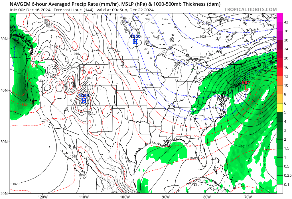
never include the navgem - period as far as the nogaps... meh. we used to call it the 'gonaps' model back in my university days for a reason. but maybe there's been some kind of extra-double top secret pentagon upgrades that only the navy's commander and chief and one or two turbo nerd modelers know about -
-
yeah ... tongue in cheek. i'm not sure what the navgem model ( seriously ... ) was really invented for. i think it's a 'frankenmodel' - kinda like the old dgex days. i used to love the dgex model. talk about a methadone clinic! storm going away in the guidance? no problem - just open the dgex and it seemed to always dependably take whatever it had on the nam at 72 hours, and manufacture like 10 closed isobars out of it. not saying the navgem does that. but one thing i know it seldom ever does is accuracy. i get the feeling though that the model isn't there to make us "happey" (heh) no, but it might have some specific application that's not intended for general operational forecasting - not sure. it's speciated out of the navy's "nogaps" model being somehow fused into the ggem if memory serves - if that was some sort of random experiment ( otherwise ...), it's time for it to go away, either way.
-
right ...then we have to fight the fact that the nam always has a nw bias in the western atl basin beyond 42 ..48 hours. lol haha can't win
-
ineedsnow ... you really should not be thanking anyone for that guffaw model
-
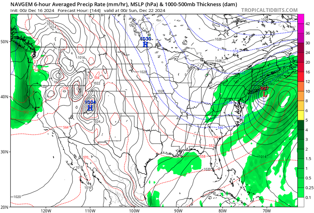
yup, typically with this model ... it's what 'not to do' - example, the 06z solution did not do what the 00z run did.
-
heh... here's one model no one probably ever even looked at .. the navgem. the 00z solution gave a 30 hour nor-easter with about 3" of liq equivalent in mostly snow
-
the gfs just does this, i swear. it puts out one run from like 12 days in advance that's balls on perfect, then spends the next 60 model run cycles raging in ocd to engineer every plausible f'n alternate universe that can exist in a reality constructed by the quantum uncertainty principle instead of the original.
-
yeah .. full disclosure, i know this thread was mainly "experimental" - and it was ... but, about mid way since i was admittedly more thinking something other than complete bullshit for this effort, too - thing is, we all know the index numerology/projections therein are made more useful by then looking at the spatial aspects of the super synopsis. hugely important to this latter facet, understanding/detecting subtle trends. one of which has been this Auschwitzian dental exam of a western ridge - never seen a +2 delta pna move be so non-committal to a western n/a ridge like this before. i'm wondering if speed in the flow this... or more phase 5 mjo that... i don't want to instill hope, or add to the seemingly problematic d-drip mania problem with this social media engagement ... ( lol ) but, this keeps reminding me of the Boxing Day storm back in 2010's, great cosmic dildo winter for specifically Ayer, Ma ... (eh hem) that storm was essentially dead and vanquished from the charts over a great initial look at like d8, too. with just 42 or something hours to go ... it came all the way back to deliberately give me, personally, 2.4" of arctic dust while ingrate trolls that didn't deserve it were rewarded with blizzard b.js yeah... heh. anyway, modeling standards really have steeply improved a lot in the last 12 years - not sure that is happening quite the same here. we are not seeing a complete loss from the charts. the vestiges of "should" happen/suggestions are still there. so if it comes back stronger in the short game, it won't be so drastic but this has been a really, really lousy drug supply. i say we switch dealers!
-
but in deference to all ... all models did exceptionally well with that - at least as far as my memory aligns. that may not have been anything particular to euro skill, but more having to do with just the uniqueness of that hemisphere at the time. unique situations tend to have overwhelming physics that tend to dominate the field while they are passing through out in time ... that's why "Sandy" and "Superstorm, 1993" and on and on, were detectable quite far out in the guidance and became eerily confident from a long way off ...unlike this giant piece of f'ing shit
-
... the forcing arrives from the pac - that induces the tpv descent ... just sayn'