

GaWx
-
Posts
18,155 -
Joined
Content Type
Profiles
Blogs
Forums
American Weather
Media Demo
Store
Gallery
Everything posted by GaWx
-
Early on Sunday afternoon (6/8) we got ~0.5” from a thunderstorm that lasted ~30 minutes. We just had a 15 minute long quick moving thunderstorm this morning (6/10) moving within the bottom of a line moving ENE. Edit: I roughly estimate 0.5” on 6/10.
-
Hey Charlie, Do you have any changed thoughts regarding the possibility of Hunga Tonga’s modern times unprecedented thrusting of so much water way up into the atmosphere being the main reason 2023 global temps had the sharp rise?
-
I agree 100% in the Pacific. But why the drastic cooling in a large part of the Atlantic, which is what he’s addressing? Maybe this is the start of a transition to -AMO?
-
Yesterday from Joe D’Aleo at WxBell: “Ocean(s) in transition? The SSTA last 30 days (-15 to +15C) Comparing 2025 to 2024: January to May 2024 vs 2025: Is this the start of a transition back to a negative AMO? The ocean changes modes on a multi-decadal cycle - 30 years of a positive this cycle followed a cold of 30 years, which followed 40 years of warm, which followed what appears 25 years of cold. The cold AMO/NAO/AO favors colder (US) regardless of ENSO.”
-
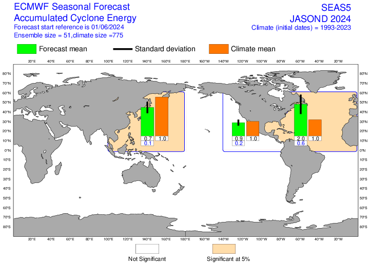
The June 2025 Euro seasonal outlook is ~same as May 2025 with near normal. I still think that’s probably somewhat underdone but it is much less active than Euro’s June 2024 seasonal outlook, including near the US: June 2025 JASOND ACE: 110% of 1993-2024 June 2024 JASOND ACE: 200% June 2025 for JASOND: SE US/Gulf near to slightly less active than 1993-2015 avg June 2024 for JASOND: SE US/TX significantly more active than 1993-2015 avg
-
Here’s the global surface air temp. graph going through 5/31/25:
-
Good catch, the biggest April to May QBO drop on record! Based on the past, the odds are increased that it will dip to sub -20 by winter and possibly even by autumn. But not for certain, of course.
-
Thanks. That shower here late last night was just a quick, isolated rain. But late this morning it has been much more widespread in SE GA. Edit: All of that rain along with some light rain the subsequent days added to ~0.75”
-
Red hot news bulletin (followup): Not at all surprisingly based on past patterns, the 30 mb QBO dropped to negative in May (-4.59) from April’s +6.94: https://psl.noaa.gov/data/correlation/qbo.data
-
I still say that the predominantly +3/2014-7/2016 during El Niño is similar to 6/1957-2/1959.
-
Without having any idea that this would occur, I got a heavy shower suddenly at ~1:45AM (6/4) but it ended after no more than 5 minutes. I looked on radar and saw that it came from a rather unusual direction, from offshore moving WNW.
-
As a near coast resident, I do fear the tendency of storms developing further W and not having as much chance to recurve E of the US though it is still plenty warm in the MDR. The projected RONI based weak La Niña like last year is not comforting as far as favored tracks and suggests another significantly impactful season on the US is quite possible. Of course, with last season being so horribly bad for the SE US, the odds are that this one won’t be nearly as bad there. Fingers crossed, especially for FL, which can’t take another horrendous year. Even my area had BOTH the worst flooding from a storm (Debby) in at least 8 years as well as widespread multi day outages (Helene) (worst since 1979/David). I’d love nothing more than another 2013, 2010, 2001, or 2000. Most of those years would also make you happy and without all of the destruction.
-
-
Please post your June 2025 observations and other current or recent conditions. @jburnsplease pin. TIA
-
1. Atlanta: -6/1/25 CANSIPS is forecasting JJA of -2.7F vs 1981-2010 avg, which would be coolest since the dry summers of 1997 and 1976, along with +0.5”/month precip. vs 1981-2010. -How did 6/1/24 CANSIPS do? -It forecasted +0.7F. But it verified at +2.9F. So, 6/1/24 CANSIPS was 2.2F too cool. -It forecasted precip of +0.4”/month vs actual of a wetter +1.15”/month. So, it was a bit too dry. 2. Tulsa: -6/1/25 CANSIPS is forecasting JJA of -3.6F vs 1981-2010 avg, which would be coolest since 2004 (wet) and 1967 (slightly wet), along with +0.75”/month precip. vs 1981-2010. -How did 6/1/24 CANSIPS do? -It forecasted +0.9F. But it verified at +1.4F. So, 6/1/24 CANSIPS was 0.5F too cool. -It forecasted precip of +0.25”/month vs actual of a slightly drier -0.31”/month. So, it was a little too wet.
-
My place ended up with a way wetter than normal ~8.7” of rainfall this month. The airport (KSAV) got 10.14”, making it the 3rd wettest May on record back to the 1870s! It was an overall warm month (~+3). This evening I took the first walk outside in quite awhile. It was very pleasant for May 31st with dewpoints down to 58 (near the lowest of the month?), temperatures in the low 70s, and a light breeze. Tomorrow should be similarly dry though temps will be 3-4 higher. So, I hope to get another walk in.
-
FL damage est. from hurricanes (In 2025 $ billions) 1960: Donna 4 1964: Cleo 1; Dora 3 1965: Betsy 1 1975: Eloise 2 1992: Andrew 58 1995: Erin 1; Opal 6 1998: Georges 1 1999: Irene 2 2004: Charley 26; Frances 15; Ivan 24; Jeanne 13 2005: Dennis 2; Katrina 1; Wilma 31 2016: Hermine 1; Matthew 4 2017: Irma 65 2018: Michael 23 2020: Sally <9 2022: Ian 110; Nicole 1 2023: Idalia 3 2024: Helene 36, Milton 14 ———————— -1992 had 58 damage from Andrew but they didn’t have another comparable year til 2004 -2004-5, combined: 112; but Citizens Property Insurance had just been created; also, FL didn’t have another comparable period til 2017-8; so things got much better -2017-8, combined: 88; but that was followed by a not nearly as bad 2019-21 overall thus helping things though Sally of 2020 was quite bad for Pensacola -2022-4, combined: 164 (worst 3 year period ever leading to insurance crisis) but there was some stabilization and even slight premium drops in 2025 due to 11 new companies entering market as well as help from Citizens -2025+ will, needless to say, be extremely crucial for FL for the stability of the FL housing market/insurance. The MHs, especially, need to avoid FL for at least the next couple of years to help things turnaround.
-
14/9/3 ACE 139
-
As of May 28th, OHC for the area of the tropical Atlantic east of the Caribbean (20W-60W) is down to near the 2013-24 average. That’s still quite warm, but it’s not nearly as warm as 2024 and is even a bit cooler than 2023. I’ll be interested to see where it is in a couple of weeks:
-
The Cocorahs map confirms what you and I saw on the radar with a sharp cutoff of solid rainfall (~1”) just to our south in southern Chatham to the islands caused by that storm skirting us to the S on its NE trek:
-
We’re about to get blasted by a strong thunderstorm just to the S moving NE. Winds are gusting. Edit: rain ended up surprisingly light considering how the radar had looked on approach though . It semi-petered out as it got here though I was on the NW corner. Total <0.1”. But most of the nearby islands appeared to get a decent hit. May has been like a summer month here.
-
Based on RONI, 2023-4’s peak was only a borderline moderate/strong +1.50 (OND) vs 2015-6’s super RONI peak of +2.038. Even 2009-10’s peak was slightly stronger with +1.56. 2023-24’s DJF RONI then fell to just +1.21. https://www.cpc.ncep.noaa.gov/data/indices/RONI.ascii.txt
-
Despite cloudy skies dominating the day, KSAV still had a near normal high of 87. This along with dewpoints ~74 much of the day made it feel quite sticky. We’ve had rain from thunderstorms the last 2 hrs . KSAV received nearly 1”. KSAV hasn’t had a high below 84 for the last two weeks! The month has averaged +3 for the mean temp. Despite a very wet month, the avg high there so far this month has been 87! This is very different from the significantly cooler northern SE!
-
JFMA surface temp. anomalies vs 1991-2020: 2025 minus 2024 (C): -E NA much colder as we know -equatorial Pacific significantly colder due to Niña vs Nino as we know -much of Atlantic dominated by significantly colder -S and C Europe as well as SE Asia much colder -Russia much warmer -Australia and further south warmer -Pacific N of 20N to Alaska and further N mainly warmer

