

GaWx
-
Posts
18,155 -
Joined
Content Type
Profiles
Blogs
Forums
American Weather
Media Demo
Store
Gallery
Everything posted by GaWx
-
NATL ACE has risen to 23.6, which is the 16th highest of the last 75 for the date. Based on the latest NHC prog, ACE would be ~42 as of late Aug 23. If that verifies, 2025 would move up to 9th or 10th of the last 75. It would also move up to ~19th or 20th of the last 175 years (~89th percentile). The only ones higher than 2025 as of Aug 23rd would be these: 2024, 2008, near tie with 2007, 2005, 1995, 1980, 1969, 1955, 1951, 1950, 1933, 1926, 1916, 1899, 1893, 1887, 1886, 1880, and 1871. 2025 would be just ahead of 2004, 1966, and 1915. @mitchnick@snowman19@PhiEaglesfan712
-
NATL ACE has risen to 23.6, which is suddenly the 16th highest of the last 75 for the date. Based on the latest NHC prog, ACE would be ~42 as of late Aug 23. If that verifies, 2025 would move up to 9th or 10th of the last 75. It would also move up to ~19th or 20th of the last 175 years (~89th percentile). The only ones higher than 2025 as of Aug 23rd would be these: 2024, 2008, near tie with 2007, 2005, 1995, 1980, 1969, 1955, 1951, 1950, 1933, 1926, 1916, 1899, 1893, 1887, 1886, 1880, and 1871. 2025 would be just ahead of 2004, 1966, and 1915.
-
Similar to yesterday earlier in the afternoon, thunderstorms with some heavy rains have just popped up including here along the seabreeze. Rain starting and just heard thunder. Edit: I ended up with ~0.80”, which brings me to ~14.4” Aug 1-17!
-
1. It’s a weak to very weak correlation at best regarding AN ACE to 35”+ NYC snow. Furthermore, correlation doesn’t necessarily mean causation. 2. If either of the two possibilities were to be the case even in a weak manner, I’d go with your 2nd option. 3. I’ve seen no indication about an even very weak correlation of recurving hurricanes and 35”+ NYC snow. 4. If anything, there may be a very weak correlation to seasons with 2+ US H hits and not the other way around. That sort of seems like the opposite 5. Regardless, how does one quantify the relationship of “recurving hurricanes” to 35”+ snowfall? That seems kind of vague/not very concrete.
-
Thanks, Don. I want to make sure I’m following you. You’re saying that the NYC snow/ACE coefficient of determination is only 1.4%? That’s next to no correlation. I thought it might have been closer to 10%/weak. Fwiw: opinions about this? ACE 160+ (20 years): NYC snow (avg is 28.1”) 1878: 35.8” 1886: 31.9” 1893: 45.5” 1906: 53.2” 1926: 22.3” 1932: 27.0” 1933: 52.0” 1950: 9.3” 1961: 18.1” 1995: 75.6” 1996: 10.0” 1998: 12.7” 1999: 16.3” 2003: 42.6” 2004: 41.0” 2005: 40.0” 2010: 61.9” 2017: 40.9” 2020: 38.6” 2024: 12.9” So, 11 of 21 (52%) of 160+ ACE seasons were followed by 35”+ at NYC vs only 44 of 156 (28%) of all seasons having 35”+ suggesting a possible weak correlation of 160+ ACE to 35”+ NYC snow. However, 11 of those 20 160+ ACE years were since only 1995! And as @bluewavesuggested, CC is probably a more significant predictive factor on high snowfall seasons than 160+ ACE. There have been 6 50”+ seasons just since 1993-4 or 19% of the last 32 winters. Prior to 1993-4, there were only 12 of 124 seasons (10%) with 50”+ snow. @snowman19
-
NYC was also very low with snow in 1950-1. Regardless, one season, alone, doesn’t destroy the theory because these correlations are not only not even close to 100%, they’re weak. If I instead had claimed it was a 100% perfect correlation, then that idea could be destroyed by just one season.
-
Due to curiosity about whether or not there likely is a connection between ACE and/or # of CONUS H hits with NE snowfall the following winter, I decided to research NE US AN winters and crunch the #s. I chose a central point with a very long history, NYC. I chose 35” as the breakpoint for AN: Hurr. seasons preceding NYC AN snow (35”+): 44 of last 156 seasons (top 28%): -AN ACE*, AN H hits (2+)**: 2020/17/05/04/03/1995/66/33/16/15/06/1898/96/93/87/80/78 -BN ACE/BN H hits (0 or 1): 2014/13/09/02/1993/77/22/19/1874 -NN ACE/AN H hits: 1960/59/48/47/38/1882/76 -NN ACE/BN H hits: 2000/57/1895/83/72 -AN ACE/BN H hits: 2010/1963/1892 -BN ACE/AN H hits: 1940/13/04 Summary of 44 H seasons preceding AN NYC snow: ACE/# of H hits: 1. AN/AN: 39% (17 seasons) preceding AN snow vs 26% of all H seasons being AN/AN 2. BN/BN: 20% (9) vs 28% 3. NN/AN 16% (7) vs 15% 4. NN/BN 11% (5) vs 13% 5. AN/BN 7% (3) vs 6% 6. BN/AN 7% (3) vs 11% ————— -AN ACE: 45% (20) vs 33% -NN ACE: 27% (12) vs 28% -BN ACE: 27% (12) vs 39% —————— -AN H hits: 61% (27) vs 52% -BN H hits: 39% (17) vs 48% ————— Conclusions -There appears to be a weak but noticeable correlation between ACE and the chance for >35” NYC snow -There appears to be a very weak but noticeable correlation between # of US H hits and the chance for >35” NYC snow -Combining these two factors, a season with both AN ACE and AN H hits, appears to give the strongest chance for >35” NYC snow with it possibly being as much as twice as high as the chance for >35” after BN ACE/BN H hits —————— *ACE norms adjusted for avg ACE of each era **Avg US H hits 1.8 1851-2024 Sources: -NYC snowfall: https://www.weather.gov/wrh/Climate?wfo=okx -ATL ACE: https://en.m.wikipedia.org/wiki/Accumulated_cyclone_energy -# of CONUS H hits: https://www.aoml.noaa.gov/hrd/hurdat/All_U.S._Hurricanes.html @PhiEaglesfan712@snowman19@donsutherland1@BlizzardWx
-
Thunderstorms that popped up along the seabreeze have resulted in moderate to heavy rain here since 1:45. I’m >1” and adding to that. So, I’m >13” for MTD! Edit: I ended up with ~1.6” on 8/16. That gets me to a whopping ~13.6” for Aug 1-16! Some in the county got as much as ~3” around the Windsor Forest area.
-
1. 2024 (161 ACE) didn’t get 2nd major til late Sep. 2. 2023 (146) didn’t have 1st MH til 8/20. 3. 2021 (146) 1st MH 8/20. 4. 2020 (180) 8/26 5. 2019 (132) 8/30 6. 2018 (133) 9/10 7. 2017 (225) 8/25 8. 2016 (141) 8/30 ——— 2025 got 1st MH on 8/16. Seasons with 1st MH by 8/16: 2024, 2008, 2005, 2004, 2000, 1996, 1995…only 7 of last 30 (23%).
-
1. 2024 (161 ACE) didn’t get 2nd major til late Sep. 2. 2023 (146) didn’t have 1st MH til 8/20. 3. 2021 (146) 1st MH 8/20. 4. 2020 (180) 8/26 5. 2019 (132) 8/30 6. 2018 (133) 9/10 7. 2017 (225) 8/25 8. 2016 (141) 8/30 ——— 2025 got 1st MH on 8/16. Seasons with 1st MH by 8/16: 2024, 2008, 2005, 2004, 2000, 1996, 1995…only 7 of last 30 (23%). Edit: We don’t need another storm even near Erin’s incredible strength to end up with an AN ACE season. @snowman19
-
Due to Erin ACE is now rapidly rising with 2025 about to cross median for the date (of last 75) and should cross mean tomorrow. 2025 should reach top 20 for the date by Mon and top 15 or higher by Tue or Wed. @snowman19@mitchnick
-
0Z UK is similar to the 12Z with a TS N of the Leewards moving WNW:NEW TROPICAL CYCLONE FORECAST TO DEVELOP AFTER 132 HOURSFORECAST POSITION AT T+132 : 15.6N 56.6WLEAD CENTRAL MAXIMUM WINDVERIFYING TIME TIME POSITION PRESSURE (MB) SPEED (KNOTS)-------------- ---- -------- ------------- -------------1200UTC 21.08.2025 132 15.6N 56.6W 1009 260000UTC 22.08.2025 144 16.3N 58.8W 1007 321200UTC 22.08.2025 156 18.1N 60.9W 1006 370000UTC 23.08.2025 168 19.4N 63.3W 1005 38
-
Any chance his idea is the right one?
-
IF that happens, the seasonal ACE would reach ~34 as of 8/22. If then another multiday hurricane were to closely follow Erin like the GFS/GEFS are suggesting could occur, having 50ish ACE by the end of August would be a reasonable possibility especially considering there could easily abe an additional weaker storm or two, which would out 2025 notably above the normal ACE through August.
-
It’s getting dark in the N sky here and the radar says strong thunderstorms are on the way as an outflow boundary is coming through: SPECIAL WEATHER STATEMENT NATIONAL WEATHER SERVICE CHARLESTON SC 635 PM EDT FRI AUG 15 2025 GAZ118-119-SCZ047-051-152330- COASTAL CHATHAM GA-INLAND CHATHAM GA-COASTAL JASPER SC-INLAND JASPER SC- 635 PM EDT FRI AUG 15 2025 ...A STRONG THUNDERSTORM WILL IMPACT JASPER AND CHATHAM COUNTIES UNTIL 730 PM EDT... AT 635 PM EDT, DOPPLER RADAR WAS TRACKING A STRONG THUNDERSTORM NEAR BELLINGER HILL AREA, MOVING SOUTHWEST AT 15 MPH. HAZARD...WIND GUSTS UP TO 50 MPH AND PENNY SIZE HAIL. SOURCE...RADAR INDICATED. IMPACT...GUSTY WINDS COULD KNOCK DOWN TREE LIMBS AND BLOW AROUND UNSECURED OBJECTS. MINOR DAMAGE TO OUTDOOR OBJECTS IS POSSIBLE. LOCATIONS IMPACTED INCLUDE... POOLER, BLUFFTON, HUTCHINSON ISLAND, DOWNTOWN SAVANNAH, BELLINGER HILL AREA, SAVANNAH INTERNATIONAL AIRPORT, GODLEY STATION, WILMINGTON ISLAND, GARDEN CITY AND PORT WENTWORTH. — Edit: I got only little. I’ll call it a T.
-
If Erin reaches cat 4 and sustains it for a couple of days or at least on and off, I think that getting close to 30 total ACE just for Erin would be attainable. @mitchnick
-
Hey snowman, How do you define a “big tropical season”? Thanks.
-
Regarding the followup to Erin that GEFS remains pretty active with, the 12Z Euro ensemble is much quieter for the same time:
-
It goes out only to Aug 29th, when it is in phase 5.
-
I count 8 of 30 (27%) of 12Z GFS ensemble members landfalling on the Conus from TX to ME within 8/27-9. GEFS suggests the MJO will most likely then be in phase 5, a rather active phase for Conus though not as active as phases 2 and 8. This is keeping me with a moderate concern for now: But the 12Z Euro like the 0Z has no TC from this. Also, it isn’t on the 12Z CMC. So, we’ll see. I already noted the 12Z UKMET with it.
-
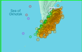
From Dr. Viterito via JB 8/14/25: I've been keeping a very close eye on this area, as it has been a geothermal hotspot helping to feed the Kuroshio Current, the Pacific's equivalent to the Gulf Stream. Did you notice at the very end of the video the narrator talks about the fact that geothermal heating enables the major port to be ice-free year round and that the area is used as a submarine base? "The "culprit" here is the submarine activity of the Eastern Volcanic Front off the east coast of Kamchatka." As the map shows, there has been a tremendous amount of underwater seismic activity in this area for the past 30 days. For the record, there have been 1036 seismic events, the vast majority of which are associated with underwater magma displacement. Keep in mind, these magmas can reach temperatures of 400 degrees C! IRIS/Wilber 3, Mx >=3, July 15 - August 14, 2025. The water off the east coast of Kamchatka moves southward vis the Kamchatka current. Here is a map of this: Wikidata The Kamchatka Current then feeds the Kuroshio Current, and in this case, is providing exceptional warmth to the Kuroshio. This is starkly illustrated in today's sea surface temperature map. In this map the source region is clearly the southeast coast of Kamchatka, and we can see that excess warmth being transported by the Kamchatka Current, which then merges with the Kuroshio. By contrast, here is the seismic map for March, 2025. For that month, there were only 17 seismic events: IRIS/Wilber 3, Mx >=3, March 6, 2025 - April 5, 2025. Here is the resultant SST map (April 6, 2026 [sic]): Clearly, the "hot spot" was much weaker when the seismic activity was lower. It can be argued that the Kamchatka source region is responsible for the large temperature anomaly the Kuroshio is currently experiencing. It's about time the climate community starts to recognize the importance of geothermal inputs into the system. ————————— Any comments?
-
Unlike the 0Z, the 12Z UKMET is back (similar to yesterday’s 12Z that I’m quoting) with a followup AEW to Erin becoming a TD at 162 and nearly to a TS at 168 just N of the Virgin Islands moving WNW. This looks like the same AEW that the 12Z GFS has but is ~500 miles further WNW than the GFS at 168, which is then only near 16N, 58W. This is the AEW causing the commotion in the SE US on the 6Z GEFS during 8/26-30: NEW TROPICAL CYCLONE FORECAST TO DEVELOP AFTER 162 HOURS FORECAST POSITION AT T+162 : 18.9N 62.8W LEAD CENTRAL MAXIMUM WIND VERIFYING TIME TIME POSITION PRESSURE (MB) SPEED (KNOTS) -------------- ---- -------- ------------- ------------- 1200UTC 22.08.2025 168 19.4N 64.7W 1005 33
-
You must be thinking of 2019’s Humberto. I’m referring to 2007’s, which hit upper TX/W LA.
-
-Just for the record fwiw, the 6Z GFS hits Daytona on Aug 29 (way out at 2 weeks) -Much more statistically significant than just a fantasyland op run, its ensemble is unsettlingly pretty active in/near the SE US during Aug 26-30. Here’s a snapshot as of hour 294 (12Z on 8/27): -During this active period, GEFS has the MJO in/near phase 5. It’s not either of the 2 most active phases for H hits per day during Jul-Sep since 1975 (phases 2 and 8), but phase 5 has had the 3rd highest ratio of hits/day. - During phase 5, these 10 Hs hit the Conus: Francine (2024), Ike (2008), Humberto (2007), Ophelia (2005), Isabel (2003), Bertha (1996), Fran (1996), Bob (1991), Elena (1985), and Babe (1977). Two areas were most impacted by these 10: NC (Ophelia, Isabel, Bertha, Fran, and Bob) and upper TX to FL panhandle (Francine, Ike, Humberto, Elena, and Babe).
-
I’ve already had the equivalent of a very wet TC with 12” of rain so far this month even without a TC! The last thing this area needs is more heavy rain as well as trees being easily toppled due to a high water table. After strong effects in ‘24 from the combo of Debby (10.9” of rain) and Helene (115 hour power outage/loss of food that took only high end TS winds/gusts to ~75 mph), I’d especially love a break. (By the way, FEMA never paid me for the food losses it promised even though I applied on the phone. ) Of course what I got pales in comparison to what others got from Helene to my W and NW and from Milton in FL. They’re the ones that especially need a break! Among other problems, the homeowner’s insurance situation is already ugly in much of the SE. I obviously like to follow and discuss these monsters and enjoy the challenge of forecasting what they’ll do. They’re also pretty to look at on satellite pics and are absolutely fascinating, but I want no part of them! Because of that, a boring quiet rest of the season wouldn’t bother me. However, I won’t let that desire bias my posts away from objectivity. Back to the present: 0Z UKMET has no followup TC to Erin unlike the prior runs.


