GaWx
-
Posts
19,218 -
Joined
Content Type
Profiles
Blogs
Forums
American Weather
Media Demo
Store
Gallery
Everything posted by GaWx
-
Actually, with the typical NW trend, which is in reality an unwinding of too far SE biases, you’re very much in this one. I think due to this and backed by climo, you have a better chance than us peeps way down in the Deep South of getting some of this. One never knows since every case is different, which makes forecasting discussions so interesting. Why is it so quiet in here? It’s not quiet at the other place. I guess most everyone here is sleeping? Or is almost everyone over there?
-
0Z GEFS has had a large increase:
-
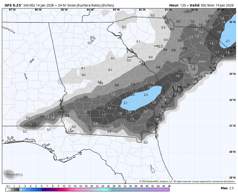
The 0Z GFS is giving >1” of snow to this area on Jan 18th, which would be the second straight Jan with measurable snow. That’s never happened since official records started 150 years ago. The closest thing to that would be Jan of 1921’s 0.5” and Jan of 1922’s major icestorm. And then the glorious Jan of 1977 had two. Climo always says bet against measurable wintry precip here as no more than 25% of winters have had that. OTOH, there has been increased ensemble support. But OTOH, there’s the typical NW trend when there’s no -NAO, which would work against it. So, keeping all of that in mind, I’m taking this with a grain (2m temps are also progged to be marginal as of now with 34-35 being the coldest):
-
I don’t think I can because I don’t have a list of La Niña by location. If you can provide that, I can break it down.
-
I didn’t break it down by La Niña location.
-
Actually, I did a study recently that surprisingly showed that Jan phase 6 in the SE (using GSP as a representative) has had a mix with a bit more cold vs warm phase 6 Jan periods. Examples of cold during La Niña in Jan: 1975 (8 BN), 1976 (9 BN during a long period of 13 days), 2000 (4 BN), 2011 (7 BN during a long period of 12 days), 2022 (9 BN), and 2025 (5 BN). There were some mild Jan phase 6 periods during La Niña also like 1989 (+8) and 2008 (+8) although those two were only 3 days long each. Keep in mind though that the current phase 6 started off mild. So, it remains to be seen how cold it will end up overall as it’s progged to last through ~Jan 21st.
-
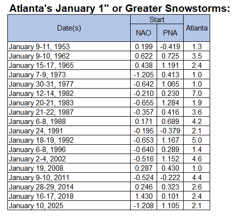
From Don Sutherland: Yes, the PNA is far more important to Atlanta's January snowstorms than the NAO. Since 1950, the PNA was positive for 84.2% of Atlanta's 1" or greater snowstorms. The NAO was negative for 63.2% of such storms. I’ll add that that these Jan snowstorms were during La Niña: Dates……PNA…….NAO 1/15-17/1965…+1.191…+0.438 1/6-8/1996…+0.289…-0.640 1/19/2008…+0.430…+0.287 1/9-10/2011…-0.223…-0.524 1/16-17/2018…+0.101…+1.430 1/10/2025…+1.105…-1.208 So, just for the six 1”+ Jan storms during La Nina: -5 of the 6 PNAs were >0 and the lowest was only down to -0.223. Avg PNA was +0.5 -In contrast, 3 of the 6 NAOs were positive with one of them strongly positive. The avg NAO was near 0/neutral. ————— The 1/18/26 potential SE snowstorm looks like it will be during a moderate MJO phase 6, a strong +PNA, a neutral to moderately -AO, slightly + to neutral NAO, -WPO, and a very strong -EPO, which may be sub -3 then. So, the highlight is strong +PNA/-EPO during a phase 6.
-
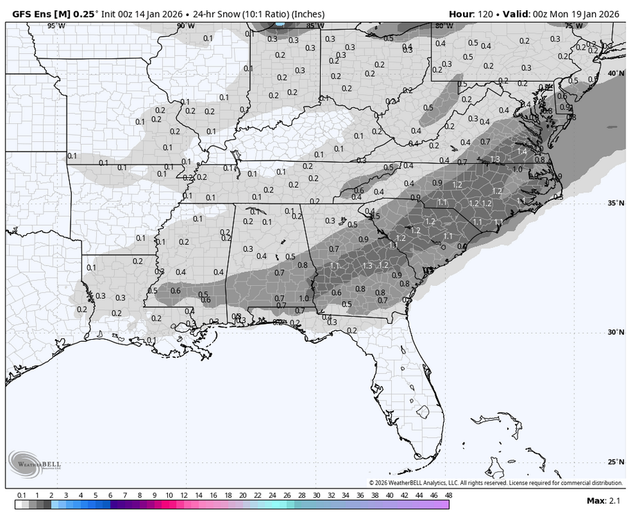
Look how much this changed in just 2 days of runs:
-
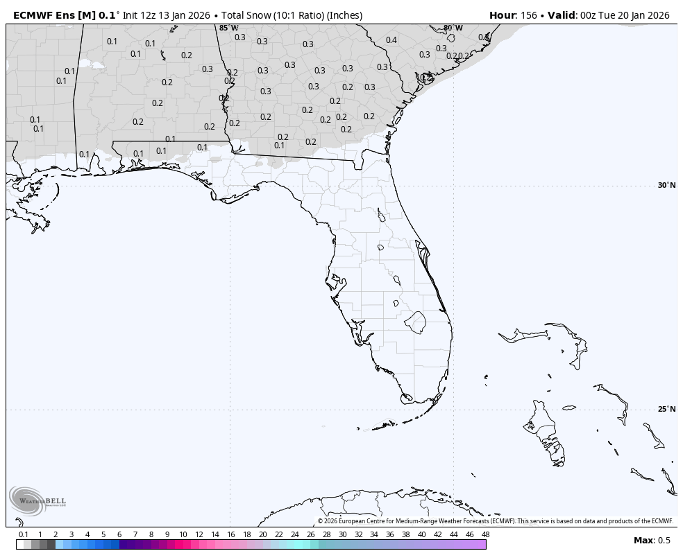
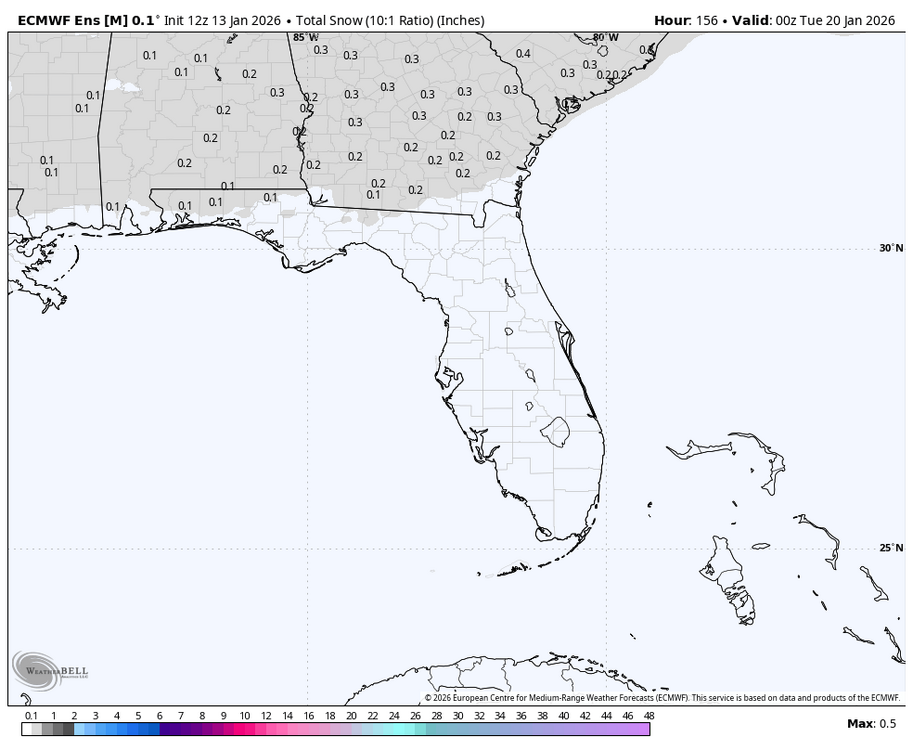
The 12Z EPS for SAV has gotten my attention for the small chance of Sun AM light snow/flurries, which in this area would be a big deal due to the relative rarity being that most winters get nothing, not even a T. We got nothing Feb 2018 through Dec 2024. My expectations, especially for measurable, are low due to climo, it being pretty dry overall with member qpf progs being light, and marginal temps. So, fwiw, here are some 12Z EPS images: ~25% of members have snow, which is notably high: Mean: 0.2”, notable for here:
-
Anthony, You just had a snowy December with two significant snowstorms and a colder than normal month. How is that the least bit boring?
-
Don, thanks. From where did you get those stats?
-
The 12Z GEFS and EPS means late in their runs both had a great combo for E US cold of a -AO, -EPO, and -WPO. The NAO is slightly negative on the EPS and ~neutral on the GEFS. The PNA rises to neutral from its prior ~7 days of being negative. Overall, that’s a combo of indices favoring cold in the E US. The MJO is then mainly in 7 and trying to go into 8. If it does, watch out! But if it stalls there and mainly avoids it, the still mainly mild Euro Weeklies for the bulk of Feb would have a better chance of being right.
-
How would a potential shift to +AAM late month play into this? Is the +AAM the dog that wags a +PNA and/or phase 8 or do other things wag the AAM? Is the AAM a leader or a follower? @SnowNiner
-
Not surprisingly, today’s GEFS mean prog has reduced the max amp of the phase 6-7 from the ~2.7 of two days ago to now being close to the Euro’s ~2.1 today (see below). But it retains the 17 day record breaking long winter phase 6. Also, note that today’s GEFS turns it left as it approaches phase 8: Yesterday’s ext GEFS didn’t turn as much: This change should be respected based on the stats for the # of DJF MJO days by phase since 2011 showing that phases 6/7 were the two most frequent phases day by day and that phase 8’s days numbered only ~1/3 of that of phase 7, which is likely due to the strong W Pac warm pool (where phase 7 resides): DJF: 1: 76 2: 96 3: 167 4: 173 5: 212 6: 249 7: 286 8: 95 Whether or not the MJO actually goes into phase 8 late this month and then proceed to 1-2-3 in the first half of Feb will probably play a big role as regards the chance for the +PNA to come right back (if it were to actually go back to a -PNA for ~a week just prior) and the resultant resumption of a cold E US as we look toward the 1st half of Feb. If it ends up not going into phase 8 in a meaningful way, the last 2 Euro Weeklies runs showing a mainly mild Feb would seem to have a better chance to verify. Let’s hope not for those who want it cold. @donsutherland1
-
I was referring to the 0Z Euro op that you had commented on when I said it had the extreme rarity of snow for nearly all active SE members. Not surprisingly because of that rarity, the 6Z 144 Euro vs 0Z 150 Euro showed that was going to be taken away from many had that run gone out further. Also, the 6Z EPS at 144 looked worse than 0Z EPS at 150.
-
Down here in the SE like at RDU/ATL, there’s also a notably higher correlation to a +PNA than to a -NAO for 3-6”+ snowstorms. The PNA seems to be the most telling single index. Speaking of which, the 0Z EPS mean actually has it coming back up to + at the end (1/26). If this occurs, that will increase the chance that Jan will end up with a net +PNA like all of the other -ENSO -PNA Dec transitioned to: However, on the GEFS, it still doesn’t get back up to +PNA as of 1/26 though it appears to be on its way just afterward, which would still mean a better than 50% chance to attain a net +PNA for Jan:
-
How? The Euro gives nearly every active SE forum member snow. How often does that actually happen? 0Z EPS members: includes a few Gulf/SE solutions (6 of 50) for the SEmost extent like the op:
-
What the? Can we stop here?
-
Folks, are y’all sitting down? Or better yet, lying down? Ok, feast your eyes on the 0Z UKMET!
-
Kudos to Euro Weeklies for having +PNA switch week of 1/12-8 as far back as this one issued 12/24: 1st run w/notable hint of +PNA; it never looked back/kept strengthening it though it mistakenly had -NAO: Today: strong +PNA, no -NAO Today’s 1/26-2/2 subtly suggesting +PNA may return then: Otherwise, maps today mild for bulk of Feb fwiw. Hoping these will change and end up wrong!
-
I’m looking forward to cold dominating the next 10 or so days! That 82 F high was a bit much. The cold will be much better for outdoor activities for me.
-
This 6-10 is a beaut from my perspective!
-
Are you implying that 2026 will probably be similar to 2017 for the rest of winter in the E US?
-
OHC continues to rise rapidly:
-
Comparisons of indices Jan ‘26 to Jan ‘17 1. Jan of 2017 was also at this time in phase 6. But that’s where the similarities end as 2017’s phase 6 was much shorter (lasted <2 days) and it sped all the way around to phase 3 by late month! It may just get to 8 at about the same time. So, MJO starting off similar but ending totally different. 2. PNA similar through Jan 21st but then 2017 went back to +PNA. We’ll see whether 2026 does that. 3. Strong +AO 2017 vs strong -AO 2026. So, AO patterns are opposites. 4. 2017 had a +NAO 1/7-18, but then it turned to a moderate -NAO 1/20-6 before rising to neutral late. 2026: -NAO til today and forecasted to head to weak +NAO for a week+. So, NAOs very different. 5. 2017 had -WPO-EPO most of first 1/2 and then +WPO/+EPO 2nd half vs 2026 having some +WPO/+EPO that’s now turning to -WPO/-EPO, which should last for awhile. So, WPO and EPO very different. In summary, other than ENSO related stuff and PNAs being similar, the other 5 indices are far different. Good luck on getting a similar result to 2017, whatever that result is.