GaWx
-
Posts
18,419 -
Joined
Content Type
Profiles
Blogs
Forums
American Weather
Media Demo
Store
Gallery
Everything posted by GaWx
-
-Note that all were between 7/3 and 10/1. -9/1/2021: post Ida interacting with front -9/4/1913: not directly from TC that moved W into SE US 9/3-4 -7/28/1913: frontal -7/3/1930: offshore frontal low -7/12/1937: frontal low -10/1/1913: frontal low that moved offshore and later became H that hit SC 10/8 -8/10/2006: frontal -8/21/2021: from nontropical event well ahead of Henri/not directly from it -9/8/2004: post Frances interacting with front -So, none directly from TC but some indirect or post TC
- 886 replies
-
- 1
-

-
- heavy rain
- flooding potential
- (and 2 more)
-
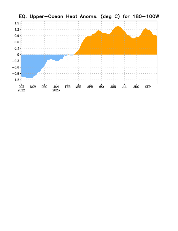
OHC hasn’t warmed back any as of ~9/23 per the following image. I had said I expected the start of rewarming by around that date per the most recent@so_whats_happeninganimation but it still hasn’t happened on this (clock is ticking):

-
Based on data since 1950, this summer’s strongly -NAO itself isn’t at all predictive of a -NAO for the upcoming winter. The factors leading to summer -NAOs, which have become much more frequent since 2007 (2/3 of those summers vs only 1/5 of summers 1950-2006), don’t necessarily continue into winter, which has had much less frequent -NAOs in recent decades. Here are years with sub -0.50 summer NAO followed by the subsequent winter’s NAO (data goes back to 1950): * = El Niño winter -2023: -1.27/????* -2019: -1.23/+1.27 -2016: -1.28/+0.65 -2015: -1.34/+1.31* -2014: -0.82/+1.66* -2012: -1.61/+0.02 -2011: -1.38/+1.37 -2010: -0.82/-0.68 -2009: -1.18/-1.67* -2008: -1.27/-0.08 -2007: -0.68/+0.65 -1998: -1.07/+0.64 -1993: -1.22/+1.22 -1987: -0.71/+0.70* -1989: -1.01/+0.69 -1974: -0.51/+0.49 -1963: -0.61/-1.43* -1962: -0.72/-1.47 -1958: -1.56/-0.30* -1957: -0.82/-0.49* -1956: -0.67/+0.42 -1954: -0.92/-0.76 Anal. of 21 DJF NAO after sub -0.5 NAO summers: - Subsequent winter: 57% (12) +NAO, 10% (2) neutral NAO, 33% (7) -NAO - There have been 11 sub -1.00 NAO summers since 1950 (excluding 2023). Of these 11, 64% (7) of the subsequent winters had a +NAO. - Of the last five of these sub -1.00 summer NAOs (2019, 2016, 2015, 2012, 2011), four were followed by a +NAO winter, including 3 of the 4 strongest +NAO winters (2019, 2015, 2011). - However, for the 7 El Niño winters, alone: 43% (3) were +NAO and 57% (4) were -NAO despite a -NAO occurring during only one of last four El Niño winter cases (2009). - Of the 7 -NAO winter cases, 4 were during El Niño Conclusions: - No correlation is suggested in general between summer -NAO, even if sub -1.00, and following winter -NAO. - Summer -NAOs have become much more frequent recently even while winter -NAOs have been less frequent in recent decades. - But 2023 being El Niño MIGHT help -NAO chances somewhat for upcoming winter. - However, El Niño sample size pretty small and most recent two El Niño cases (2015 and 2014) had two of the three strongest +NAO winters. - There have been only 6 -NAO winters during the last 44 and those all had low (~30 or fewer) sunspots. In contrast, the upcoming winter sunspot # is expected to be very high (~150+). - Based on all the above, I’m maintaining my earlier prediction that despite this summer’s strong -NAO that the upcoming winter NAO will not average sub -0.25 (my def of -NAO) though I’m currently leaning -NAO for February. Monthly NAO: https://www.cpc.ncep.noaa.gov/products/precip/CWlink/pna/norm.nao.monthly.b5001.current.ascii.table
-
I’m not a big Bastardi fan these days due to what I feel is a serious lack of objectivity and apparent hidden agendas, but I suspect that many here will agree with this at least to some extent (sounds like a RONI better indicator than ONI idea, which I think has merit):
-
I said per the above that the -SOI streak would probably end by yesterday. It still hasn’t ended with the streak barely hanging on with -3 today making it a 39 day -SOI streak per this: https://www.longpaddock.qld.gov.au/soi/
-
Just to clarify since this has come up before, there’s no indication that 1925-6 was anything close to a super strong El Niño. These two sources suggest it peaked at only low end strong: https://www.webberweather.com/ensemble-oceanic-nino-index.html https://data.coaps.fsu.edu/pub/JMA_SST_Index/jmasst1868-today.filter-5 -1896-7 and 1930-1 were stronger per these sources though still short of super. -1877-8 was almost certainly super and 1888-9 was probably super per these
-
There’s very likely not going to be much left of Philippe once getting close to PR if it takes this track instead of recurving. It would pretty much be a nonentity with it sheared to near nothing as this NHC map shows. OTOH, a recurve would keep it going much longer and possibly allow for restrengthening. See the 12Z GFS for example.
-
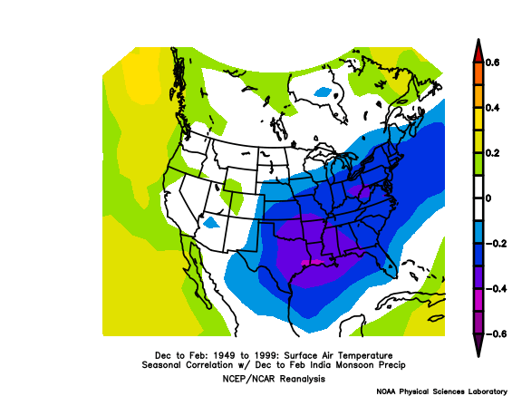
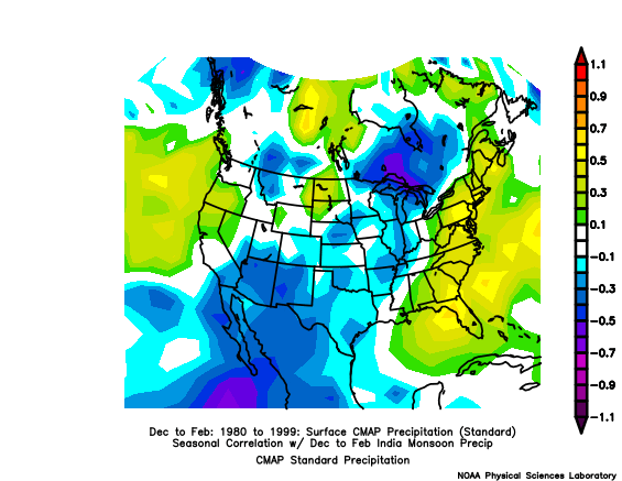
I need to rethink this because I was neglecting to keep in mind that the wet Indian monsoon season is only in summer with winter monsoon being dry. So, I don’t know if there’s much value to this correlation map between DJF Indian monsoon precip and E US BN temperature correlation. Only if the typically limited winter Indian monsoon rainfall is less limited on average during +IOD could this be of much value. So, only if that’s the case would the posted map have any value in trying to determine a relationship between winter +IOD and winter US temperatures.
-
Although not at all resembling a typical moderate to strong El Niño in terms of ACE and # of systems, it has resembled El Niño in terms of dominant general tracks due to a weaker than average Bermuda high. Fortunately, only one of six hurricanes to this point made landfall at that strength along with minimal casualties (though any is too many) from the one that did, Idalia.
-
The PDF “corrected” CFS had Sep as a whole at only 1.1 a few weeks back. I remember posting ~9/7 that with the 1.5+ for 9/1-7 that the dailies would have to plunge to ~0.75 within ~2 weeks for a mere 1.1 to occur, which of course nobody believed possible. You can see that this one initialized Sep with 1.6, which is about where Sep will end up. This means that that “corrected” CFS will end up verifying ~0.5 too cool! This run has Oct at a mere 1.2. This will almost certainly similarly verify too cool and very likely much too cool, perhaps with a similar or greater error. Ironically, the “corrected” CFS runs seem to be much less correct than the uncorrected! If it ain’t broke, don’t fix it.
-
I saw that as that area is cooler than it had been. However, note that the sub-0C portion that had been located within 125-300 m depth from 130 to 180W as of the 9/19 five day map warmed rather substantially/diminished in volume from then through the final map after having cooled and expanded substantially from the start til then. I expect that portion in itself will have a notable impact on the overall average OHC warming in addition to the notable warming near 120W. That’s why I’m leaning to notable warming coming on the next few OHC graphs, which are 5 days behind your last map.
-
After looking at this great animation, which goes up to the 5 day period centered on Sep 23, I feel pretty confident that the next 180-100W OHC graph that I post will finally be warmer and with possibly enough warming to make it somewhat noteworthy. (After looking again at the animation more closely, I’m leaning toward it being a noteworthy warming.) The last one available goes only through ~9/18. Thus your animation goes out five days further and allows me to get a feel for its next update.
-
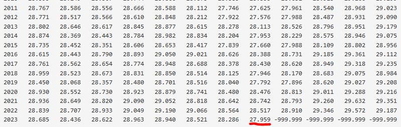
Regardless, are you aware that Aug of 2023 was > 1/2C colder in the WPAC region covering 15N to 15S, 120-160E, than Aug of 2022? (see the 27.959 C highlighted in the table below). It will be interesting to see where Sep of 2023 ends up. Is Aug just a blip or is it a sign of somewhat cooler SSTs there this winter vs recent ones? If it is, maybe that will help decrease the dominance of its forcing and thus hopefully decrease the dominance of the dreaded SE ridge: https://psl.noaa.gov/cgi-bin/data/timeseries/timeseries.pl?ntype=1&var=SST&level=2000&lat1=15&lat2=-15&lon1=120&lon2=160&iseas=0&mon1=0&mon2=11&iarea=0&typeout=1&Submit=Create+Timeseries This is an area being followed by a pro met (Brad Harvey) whom I follow. He’s who marked that box and highlighted the cooler Aug of 23 two weeks ago in an email to me. I was waiting for the right time to share this and this is the time. But regardless, he told me to share if and when I wanted to. I know him well and he has no hidden agenda as far as I can tell. Just tells it exactly like he sees it using objective data/facts. Doesn’t favor warm or cold or wet or dry. He’s not a weenie. He’s an anti-Bastardi in that respect.
-
I’d take the 1C AN that it is showing down here, especially with it vs 1984-2009 climo instead of the warmer 1991-2020 climo, though the weenie in me is hoping for NN to 1C BN since El Niño is the best shot at a BN SE.
-
He/she knows it won’t happen. Besides, this is just one of the daily runs of the awful CFS that happens to be cold (though I wonder if it really is as cold as this WxBell map shows) and it is looking out 3-6 months. Individual runs as one would expect jump around so much from run to run and have hardly any value. In contrast, here is the much more believable mean of the last 12 CFS runs (from TT), which shows much of the E US 2-4F warmer than the 1984-2009 baseline vs the totally unbelievable 5-9F colder than the 1981-2010 baseline map from today’s 0Z run:
-
1. Isn’t 1997 the record high rather than 2019? I know there are apparently different ways to measure it based on what I said in my earlier post. But the table I’ve been using back to 1870 has 11/1997 at +1.279 and 10/2019 at +0.964. 2. Wow, that’s a bold prediction based on the Euro being highest of the Sep runs for the monthly at ~+1.75. Even if you mean just one week peaking well over +2, that’s really going out on a limb!
-
How high do you expect the current +IOD to peak (on a monthly basis)?
-
Do you think that the IOD being a dipole based index rather than a monopole based index (like the ONI) makes a difference?
-
I think these are fair points. For example, what about those who keep talking about the July of 2023 101 F buoy water temp (barely off S FL in very shallow water) as a legit “SST” when it really isn’t? Or immediately blaming AGW as the primary cause of the Maui fires as a knee-jerk reaction without strong evidence to support that or time to research it?
-
Yep. My first inclination is to extra carefully assess the objectivity or accuracy of anything intertwined with politics regardless of the party, side, etc, before accepting as factual. For example, I feel Joe Bastardi is highly guilty of letting a political agenda cloud the objectivity of his tweets when it comes to AGW. He’s not denying the existence of GW, but he is denying the extent that AGW is responsible for it. His bias may also be due to having energy clients.
-
Now that I decided to learn more about IOD thanks to you, I just noticed that this Ben Noll tweet has two questionable things. He said: “The IOD is in its positive phase, corresponding to warmer than average conditions in the eastern tropical Indian Ocean and cooler than average conditions in the west. With data in through August, only 1994 and 2019 had a stronger positive Indian Ocean Dipole signal than 2023.” ———————— 1. He must have meant to say the reverse (warm west not east and cool east not west). 2. He mentioned 1994 and 2019, but what about 1997? Per the table at the following link, it in November set the record strongest +IOD (this is an apples to apples comparison): https://psl.noaa.gov/gcos_wgsp/Timeseries/Data/dmi.had.long.data Ben’s tweet:
-
Some of what I’ve just learned about IOD index history: - Tends to be strongest during strong El Niño with peak a little earlier - Vast majority of months -IOD 1870-1960 with gradual decrease of -IOD domination since then, especially last 20 years - 1870-1913: only 3 years with consecutive -IOD months were during strong El Niños of 1877, 1896, and 1902. - Highest IOD month 1870-1960 was only +0.558 (1877) - But since then, there have been 22 months >+0.558 - Longest +IOD string of months 1870-1960 was only 5 months (Nino years 1877 and 1920) - 1961-2022: there were 18 of the 5+ month +IOD streaks - 1961-2022: longest +IOD streak 23 mos 2018-20 - Record high IOD: +1.279 (Nov of 1997) - Thus for whatever reason, the IOD has been rising over the last 100+ years and especially the last 20 years. I wonder if this is loosely related to the warming Maritime Continent. Is GW leading the W Indian Ocean to warm more quickly than the E Indian Ocean? If so, why? I’m using the table at the link below for IOD back to 1870. I see that there are other tables with different values and that the model predictions of a +1.4 to +1.75 peak in Oct don’t jibe with this table for whatever reason. Apparently, the model predictions are not calling for record highs. Check this out from BoM, which shows a +2 in Oct of 2019: http://www.bom.gov.au/climate/enso/indices.shtml?bookmark=iod The table I’m using has only +0.964 in Oct of 2019: https://psl.noaa.gov/gcos_wgsp/Timeseries/Data/dmi.had.long.data So, apples to oranges.
-
Regardless, I give @snowman19 100% credit for making me aware of its existence. And I’m just now realizing the significance of the new record high IOD levels he’s been mentioning.
-
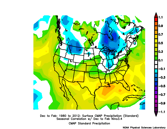
I already thought that mainly based on El Niño along with some potential help from -qbo. But after just seeing the following map showing a moderate to strong correlation of Indian Monsoon precip with precip along the entire E coast, that wetter than normal should not only be further enhanced but it has a good shot at extending into much of the NE, especially closer to the coast (though caution advised because based on only 20 year period 1980-99, when strongest +IODs were during 1997, 1994, and 1982):
-
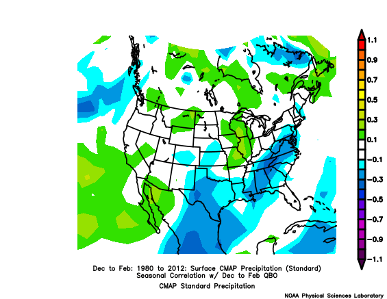
Correlation of QBO and precip: In E US: moderate -correlation (mainly 20-30%) centered on Appalachians, slight -correlation (10-20%) surrounding areas. So, upcoming -QBO would seem to moderately favor above avg precip especially those areas: Of course, the strong El Niño strongly favors wetter than normal especially along the SE and Gulf coasts and thus will be the main precip anomaly driver in the S US: