wx2fish
-
Posts
2,631 -
Joined
-
Last visited
Content Type
Profiles
Blogs
Forums
American Weather
Media Demo
Store
Gallery
Everything posted by wx2fish
-
A jack for the chickens
-
It was a toss when it had over 1.25"+ qpf for many. Coming back to reality. Still gonna be a decent event for most imo
-
Big bump. Atleast on the early low res graphics
-
Way NW. Precip output looks blotchy and weird, atleast on cod graphics.
-
Can't really find great data around here back that far, atleast for active sites. 88-89 has to be a contender too. 20.7" at the Hudson Coop.
-
I lost 3/4" Christmas eve day in the low 30s. Low water content stuff really needs to be more than 1.5-2" to have better staying power.
-
2.8". Best snow of the day now
-
6-8" ice on some ponds here and open water next to it yesterday. Skimmed over and snow on top now. Not a good recipe for those who don't know the areas that just froze over.
-
~2". Steady light snow
-
Most of the high res seem to be upticking a bit at 12z. Not sure well see the hrrr slam band offshore, but it's possible I guess. Could suprise someone between Kittery and Cape Ann
-
MHT dead nuts avg now. Meanwhile BOS is -2. Lack of climo rad cooling probably showing up there at BOS
-
Definitely a bit of an IVT sig. Rgem is pretty paltry, but has a pretty good band offshore into Cape Ann. Definitely something to watch
-
Starts warming aloft but stays super inverted below it. Tomorrow it's like 0C here at 850 and NW winds...normally a torch
-
Upslope areas the only ones cashing in this week. Pittsburg looks like 12-18"+ pack, atleast First CT lake northward, based on the obs Ive seen. Several more inches on the the way too.
-
Ha, I'm not expecting much of anything. But this season an inch is a decent event here.
-
High res models (except HRRR) picking up on some light banding tomorrow across SNH into NE MA.
-
Definitely won't see thay combo again. Temps were overshadowed by the snow. It was as consistently cold as it gets. Set monthly and maybe a couple all time monthly records? NNE had plenty of -30s, but for SNE no cold shot was all that extradinary, just consistent way BN cold for weeks.
-
Some hints at an IVT type look into Tuesday, but obviously that's a fickle setup.
-
CON has still been pulling -10F or lower pretty consistently (missed in 2020/2021 and last year). Last winter was such a torch the yearly min was the cold snap in Dec
-
Definitely the epicenter over the past couple of years there. Sitting at 2.5" here this year, which is around 10% of normal to date, brutal.
-
Wind is relenetless. MHT G42KT
-
Cant even do that right with this wind. Anything with any size that has open water is struggling to lock up
-
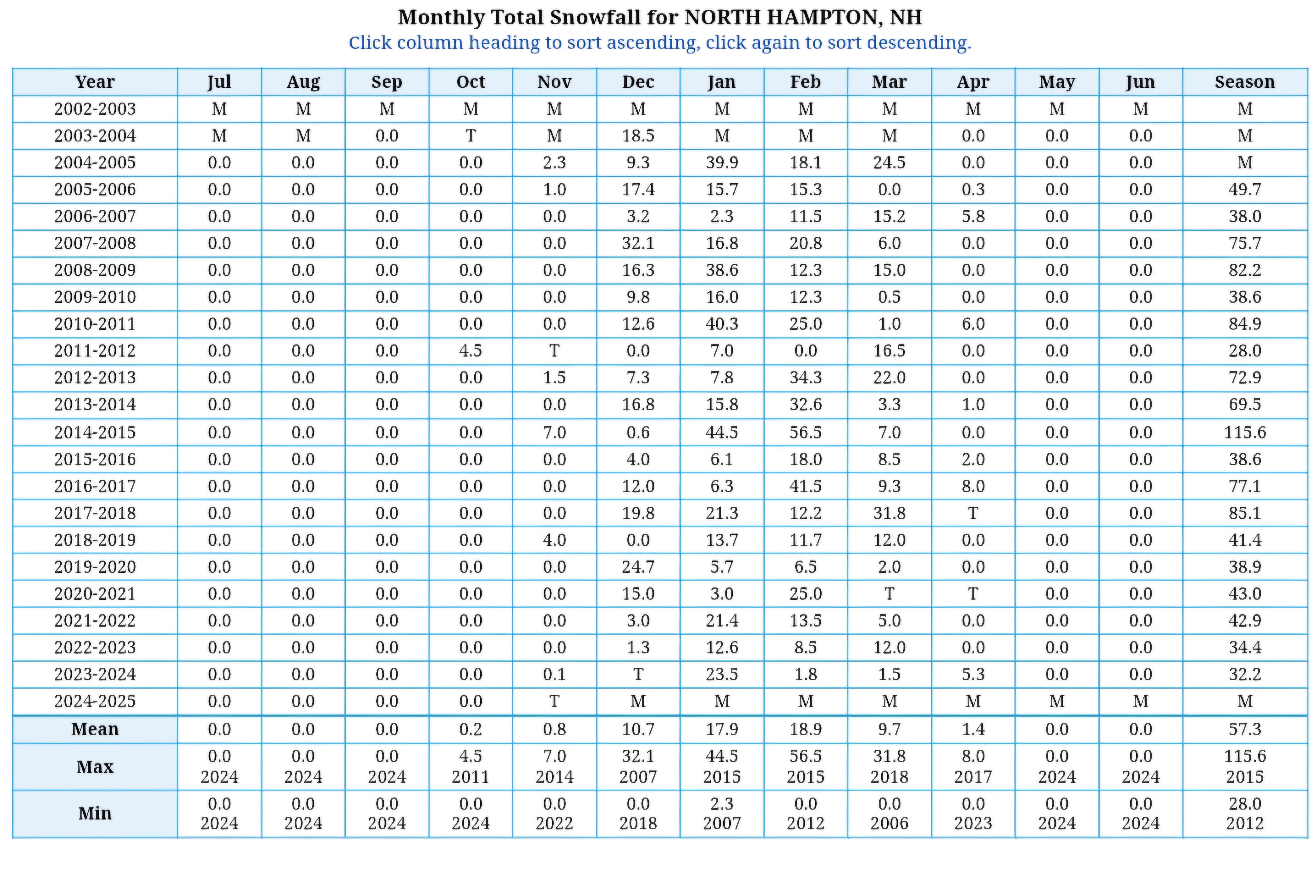
Really annoying and hard to find a coop site with complete data, but this one seems decent in Hampton
-
Euro showing a little more interest in that system than 0z
-
Yeah I mean after the last 2 Jan's it's a pretty solid stretch of sustained winter like cold. It would be a great stretch if we had a snowpack to maintain. Does look colder across NNE at times, especially for the upslope areas. Lots of deep mixing and downsloping on this side of the terrain.