

Windspeed
-
Posts
4,840 -
Joined
-
Last visited
Content Type
Profiles
Blogs
Forums
American Weather
Media Demo
Store
Gallery
Everything posted by Windspeed
-
 Like clockwork, watch the intense CBs and overall CDO structure rapidly improving on satellite. That was perfect timing for recon. It looks like Beryl is back on the upswing. Perhaps the EWRC had already completed, and the core is taking off again...
 -
The northern quadrant is definitely still packing. Wouldn't want to downgrade despite the ragged satellite appearance with such in situ data support of a high-end Category 4. Though one would expect the satellite appearance to improve if the new northern eyewall band is that strong. Satellite can be deceiving sometimes versus actual core structure. Some of the cloudfill in the eye may simply be high cirrus and not indicative of weaker convection.
-
Lol... These SFMR readings are ridiculous.
-
Lots of comparisons to Ivan and Gilbert with respect to Jamaica impacts on social media. I don't want to downplay Beryl, as folks there should prepare for a major hurricane landfall, or worst case, but potential is there for significant weakening of Beryl before it reaches the island. Those two storms were either rapidly intensifying (Gilbert) or close to MPI (Ivan) on their approach. Unless the TUTT closes off post haste and retrogrades quickly (this appears unlikely) prior to Beryl reaching Jamaica, Beryl should still be in a weakening trend on approach. It may even drop below Category 3 status prior to interaction. There are obvious differences between a weakening vortex and one that is intensifying or close to MPI. Again, trying not to downplay potential wind impacts there, I just do not think Beryl will be as severe as those previous TCs. Perhaps shear will do its job here. I should note that most of the TC (HWF and HAFS suites) models do maintain a major huricane on impact for now. We shall see... I am concerned for flash flooding and mudslides. Not just for Jamaica, but Haiti as well. It's an old hat with these strong Caribbean TCs, but there is a strong boundary of ascent between Beryl and the ridge to the north. Training bands combined with orographic lift over the mountains of Hispaniola are going to squeeze 10-20 inches out of that airmass, despite Beryl's swift forward motion.
-
The frequency of events has had an effect, however, in combination with economic status. Strict building codes are a recent development versus decades of lower income infrastructure. Prior to the 2000s, you could count the number of major landfalling GOM hurricanes on one hand since the population boom of the 1950s. Strict codes weren't in practice. Now we do have codes being implemented. But you consider the average household income and the cost of building? Take a supply list to Lowe's. Good luck. Poor people in general, not just contractors, do what they can to cut corners. I do not think mobile home parks should even exist near hurricane prone regions. Not to confuse with RV parks, because those are temporary, and you can evacuate them. But specifically, trailer homes. Additionally, for as great and world hyped as the US is as a military and economic superpower, there is a huge separation between the lower working classes and the few percent that can afford stricter building codes. The vast majority of its citizens struggle paycheck to paycheck. Most cannot afford to spend 300k on a home that can withstand a major hurricane. These islands, and Latin nations, may be poorer countries, yet they somehow have better access to lower cost building infrastructure than Americans do. I am not arguing your point. I am simply stating empirical observation that the odds of an eyewall crossing your home are very low even along the GOM coastal region. People do what they can to survive the cost of living. The Southeastern US struggles with more than just building practices. Hence why we are where we are. You brought up California. Try to shop for a home there. If you can afford it, you aren't worried about building materials.
-
This ERC isn't going as smoothly as the first. Atmospheric conditons likely aren't what they were before with the TUTT in place. Still, the new eyewall should take over eventually, and the core is still outside of the strong axis of shear. Beryl should still be a major hurricane as it approaches Jamaica. Still, some questions remain on if the TUTT can get pinched off and where exactly the ULL develops with regards to shear in the NW Caribbean. RE: Building codes. Most structures in the Windwards are made to withstand high winds. Generations of folks that aren't strangers to high wind events, most of which aren't due to hurricanes, but strong trade winds by the occasional stout low level easterly jet, beyond just an easterly storm or tropical disturbance. They don't have to necessarily be under threat of a hurricane to have gusty 30-60 mph days. That kind of weather is much less common along the GOM coastline unless there actually is a tropical cyclone. Unfortunately, it's a situation of economic factors and poor demographics versus the low frequency of high wind events, even if you live near the GOM coastline, that has led to years of bad building practices. Not everyone can afford a hurricane house, much less afford to live in a well-built house at all, hence all the mobile home parks and cheap flats that plague our residential infrastructure.
-
The CDO in the western semicircle has periodically warmed. A sign that Beryl has peaked whether by influences of southwesterly shear or perhaps some structural changes are in progress. Either way, Beryl remains intense. The eye appears to be decreasing in diameter as well. Perhaps an outer band is finally taking over. Note the cloud pattern in the southern periphery of the eye. That is very typical of an inner eye fluctuating versus a strengthening outer band. Suspicious-looking that perhaps an EWRC has finally commenced.
-
If this is an accurate video, Union Island in the Grenadines looks trashed.
-
Last MW pass scored a hit. And, well... though banding is evident, the eyewall remains solid and healthy. Edit: Corrected image to SSMIS pass.
-
Beryl has gone over 24 hours since the completion of its last EWRC. Perhaps a concentric band has intensified since last recon. I have no idea, as the most recent MW pass missed the TC. Regardless, the eyewall remains very stable. We may even have a sub 930s central pressure now due to the duration of persistent deep convection overnight. It doesn't look like Beryl has leveled off yet. Unfortunately, we've to wait a few more hours until the next reconnaissance mission.
-
Meanwhile, Beryl continues to rip and may still be intensifying...
-
In short, there is shear just to Beryl's NW. You can see strong 300-200 hPa level southwesterly flow blowing off the tops of storms in Beryl's bands to the north of the circulation. But the core remains separated from this stronger upper flow for now. How long Beryl's core remains undisturbed from that flow? Perhaps it can shrug it off until late Tuesday (today). Inevitably, it will have some impact. We'll have to watch how that upper tropospheric trough (TUTT) evolves, and if that fearure can close off and reteograde west (and at what distance it does so from Beryl) in the coming days. This will have a direct impact on Beryl and if it can maintain Major Hurricane intensity in close proximity to Jamaica. I do expect we will see a weakening hurricane, but how much and how quickly is the big question.
-
Pressures falling down into the 920s would be extremely impressive considering the higher background pressure regime across the eastern Caribbean and SW Atlantic Basin right now. 22 mph (19 kts) on a WNW heading is indicative of how strong the flow around the SPHS remains. Honestly, if Beryl wasn't already such a powerful vortex, or rather, a weak or developing TC, it would likely be having coupling issues with surface convergence and efficiency of latent heat content despite high SSTs. It's moving about as fast as Andrew was during its status as a Cat 5. I believe Janet was even a bit faster at 24 mph (21 kts). So fast Cat 5s do happen, obviously, but only after they're already strong TCs. Edit: Actually, Andrew's top speed of 18 mph (16 kts) didn't occur until it reached the Bahamas. I am trying to find some other Category 5s that compare to Beryl with regards to forward motion if anyone wants to contribute. Edit 2: Hurricane Ivan was moving at 17 mph when it attained Category 5 status in the same general area of ECARIB. Interestingly, it had a swift motion of 21 mph as a Category 4 storm in the MDR, but gradually slowed down to around 16 mph upon its tear through the ECARIB, then to nearly a stall and NW turn after Jamaica. *still looking*
-
Good thread with an excellent cross section on Beryl's structure.
-
We were most likely too close to the 11PM AST advisory package for the need of a special update. But I do anticipate an upgrade to at least 160 now in the advisory, perhaps even 165, as that would be supported by recon data conservatively.
-
Depends on the level and strength of the flow versus the steering layer and the storm structure. Strong wind flow above 300 hPa level can ventilate a core versus any shear hindrance if the steering motion is similar. If the upper flow is below that, it may tilt the vortex column negatively. Likewise, opposing upper level flow against storm motion, even above 300 hPa level will affect the core negatively to the point the vortex will be disrupted. We have seen trough-influenced hurricanes embedded within shear intensify rapidly regardless of vortex tilt due to mass divergence aloft and ventilation overcoming shear. In Beryl's case, it will face opposing upper level flow versus its steering flow at some point tomorrow into the middle of the week. We would assume a weakening trend, but Beryl is a well-developed TC. Perhaps it can counter that somewhat; though most likely, it will not. At least climatology says it will not. We'll just have to see how the TUTT evolves and then how any resulting ULL that may form out ahead of Beryl evolves. If it closes off at a further distance from the TC, it may lessen shear and enhance ventilation. However, if that ULL is too close or the TUTT is placed over Beryl, most likely, the hurricane will weaken significantly. Furthermore, if the TUTTs flow is too deep into the mid levels (500-400 hPa), it most certainly will disrupt the core faster.
-
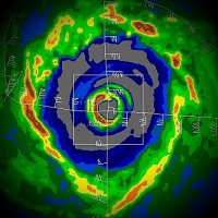
I don't really see any evidence of an outer wind maxima yet. Will be curious to see the turn here for recon if they try to sample the NE quadrant one more time. Beryl still has an opportunity to strengthen overnight prior to any upper level environment degrading on Tuesday. Edit: They made a left turn. Looks like they will try to punch the west eyewall or SW quadrant and then attempt to sample the NE quadrant one more time. Also, I need to correct myself. There was indeed an outer maxima in the band to the east and northeast of the NE eyewall on that first pass, though subtle, just not an outer maxima in the SW quadrant. Edit 2: Nevermind, I read the FLWs wrong as the plane was closing in on the core. There is a strong band there, but it's more of a plateau, not a spike in winds. That doesn't really constitute an outer maxima. Here is a nice radar presentation from ENCWX.
-
That dropsonde was impressive. 21°C down to 700 hPa. Also, regardless of any structural evolution, the vortex message shows a well-stacked core. There does not appear any negligible tilt from 850 hPa up. So for now, at least, Beryl is not much impeded by the continued moderate mid-level easterly flow. Of course, its swift forward motion from the steering layer is helping that. Westerly upper level flow and impactful shear may begin to increase on Tuesday. Beryl's size and organization may be able to battle against that somewhat if shear doesn't get too strong.
-
Ooof. Well, there will be several more passes on this mission. Oh well, hurricane records are just for us nerds. Beryl remains an insane beast for July 1st regardless.
-
The central pressure given the background environment and the flight level wind reduction alone would support a 160 mph hurricane if the NHC chose to upgrade. That being said, it appears something is off with the SFMR instrument.
-
I think they're setting up for a NE to SW quad pass. If Beryl attained Category 5 a few hours ago, even if there is an outer wind maxima from a double eyewall, the inner is most likely still cranking 156+. Just based on the color differences in banding on IR, I don't think the current cycle or merger is mature enough to rob Beryl of peak intensity yet. They should have vortex data within the hour.
-
Beryl does have strong banding that will inevitably lead to another EWRC or at least a merger. There are still CBs ongoing; the core appearance remains healthy, but there may also be a double eyewall structure in the eastern semicircle. Need recon or an MW scan, but overall, Beryl still looks like a high-end TC. Anxious for the next recon pass to see what is under the hood.
-
Beryl is currently around 13.3N 63.8W looking at imagery. The last hurricane this strong near those coordinates in the eastern Caribbean was Maria in 2017. Maria was at Category 5 intensity, but in September, with more climatological support. Remote sensing data has suggested Beryl may have continued to drop in pressure since the last reconnaissance data. The next flight may find that Beryl is now a Category 5 as well. If so, Beryl would be the earliest in record-keeping, breaking Emily's July 16th date.
-
That eyewall is cranking. Anxious what the next recon pass finds.
-
https://x.com/AndyHazelton/status/1807774281310281865?t=tNPW2luQAJKikw3rOZSZgQ&s=19


