Go Kart Mozart
-
Posts
3,141 -
Joined
-
Last visited
Content Type
Profiles
Blogs
Forums
American Weather
Media Demo
Store
Gallery
Everything posted by Go Kart Mozart
-
18.7
-
let's do 1936.
-
Congrats Shreveport
-
01-02. I remember watching a football game at Ramapo HS in NJ, December, temp in the upper 70's, wearing a T-shirt. Apropos of nothing, Greg Olsen played in that game. I recall the rest of the winter blew chunks, but the next two were first rate.
-
Ball shrinking New Year's Eve on euro.
-
Are you looking at the MJO making another run through the MC starting around the 10th?
-
The long euro looks close to something really big. A capture hook-and-ladder would be nice.
-
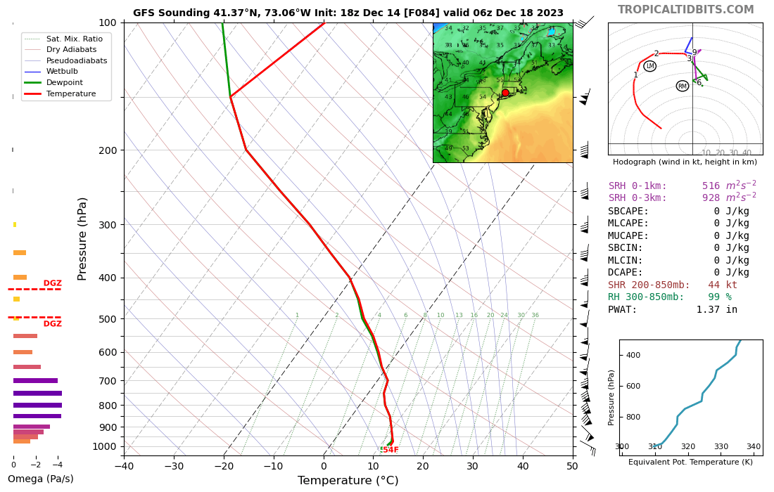
Sunday, December 17 - Monday, December 18, 2023 Storm
Go Kart Mozart replied to weatherwiz's topic in New England
Good wind down here though, lot's of +50s, even as far west as Greenwich. -
Has an icy look with the cold air - shallow as it first bleeds in. Ice to sleet to snow is fun for all. Decent wind gradient too.
-
Sunday, December 17 - Monday, December 18, 2023 Storm
Go Kart Mozart replied to weatherwiz's topic in New England
That right-moving line approaching the Cape looks wild. -
Sunday, December 17 - Monday, December 18, 2023 Storm
Go Kart Mozart replied to weatherwiz's topic in New England
Sun is poking out in Westport, CT -
Sunday, December 17 - Monday, December 18, 2023 Storm
Go Kart Mozart replied to weatherwiz's topic in New England
You tried to tell them. -
Sunday, December 17 - Monday, December 18, 2023 Storm
Go Kart Mozart replied to weatherwiz's topic in New England

-
Sunday, December 17 - Monday, December 18, 2023 Storm
Go Kart Mozart replied to weatherwiz's topic in New England
We just had a four minute downpour from a shower that showed as a little pin prick on radar. A harbinger of what's to come. -
Sunday, December 17 - Monday, December 18, 2023 Storm
Go Kart Mozart replied to weatherwiz's topic in New England
OK. East winds veering to SE, sustained140 gusting to 220. -
GFS looks east too. Less wind, but more drought-busting rains.
-
Awesome setup!
-
Wow, that's an impressive beat down of the old record, and mid-month!
-
I remember coming home from college at Christmas beak, freshman year. SWCT had accumulated 0 snow at that point. That was 1977.
-
Yup. Another example of CC making our world uninhabitable.
-
I liked the old version - "Navgem George"
-
I don't know how anyone downplays the wind. No inversion at all.
-
Hmm, 63mb gradient on GFS. Looks like the low-level cold will be pretty much scrubbed out too.
-
Yes, hybrids are a good thing. And I think you just won the acronym usage award for 2023!
-
Yes, that's the exception, but I am hard pressed to think of another B that didn't give more to my west and east. Not to say that As can't screw us too, but I think that is more of a stochastic thing, while the B screwage has a physical explanation (at least in my mind).