Go Kart Mozart
-
Posts
3,128 -
Joined
-
Last visited
Content Type
Profiles
Blogs
Forums
American Weather
Media Demo
Store
Gallery
Everything posted by Go Kart Mozart
-
I thought the same thing. Maybe he/she lives up the Rte 2 hill to the west of downtown.
-
Check out Iowa State vs. Kansas State on TV, snow game!
-
If I ignore the amber colors and just look at the shape of the December pattern...I would expect a cooler result.
-
Winter '23-'24 Will Be A Lesson In Relativity
Go Kart Mozart replied to 40/70 Benchmark's topic in New England
I finally have had a chance to read the whole thing. Great research Ray, very educational for us amateurs. I hope you err on the low side! -
It's the day-10 euro, but that shortwave near the Quad Cities is dynamite.
-
Now that's a mangled metaphor.
-
A lot of ENE recorded their strongest gusts ever in that storm. This map is on the clown-edge, but it's a big problem for south-facing bays and inlets.
-
You didn't get the mangled flakes on 11/1?
-
Damn the pattern is looking interesting. Maybe not for specific storm threats, but the positioning of the features, the crazy amplitude...wowzers!
-
-
The operationals in the longer range....Geez!
-
Gracias
-
This may be all sound and fury signifying nothing, but there is a lot of talk on certain websites about the current solar cycle coming to an early peak. Any thoughts?
-
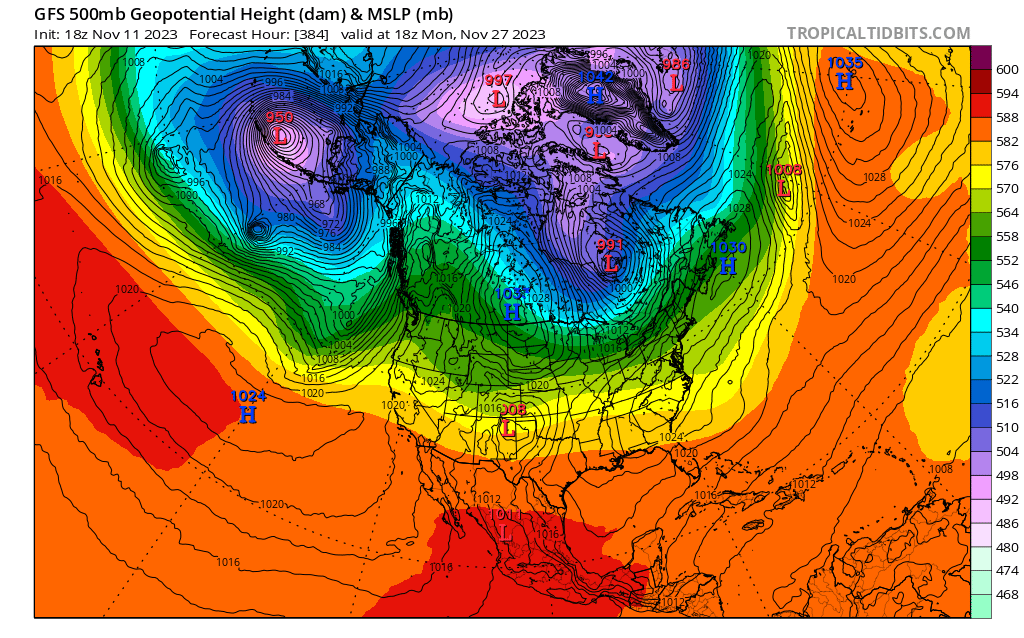
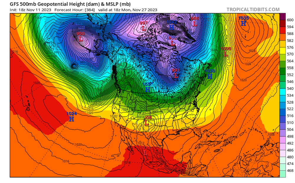
I post this 384 map as an academic exercise only....note the 1042 HP at the surface over Greenland, with very low heights. Normally, I would expect to see elevated heights with a 1042 high. Can a pro educate me....how can the atmosphere be so heavy and yet so cold aloft? And for more fun, check out the 2m temps under that high. "Real cold".
-
I thought he lost his fortune at the Wampanoag casino?
-
Damn, that's close to a destructive storm. Maybe a half day faster with the TC, or slower with the trough.
-
Like this?


-
9" in Trumbull, we were in kind of a sweet spot. Thank God a crew from Indiana had restored our power a couple of days earlier!
-
I think the 18z GFS days 16-19 would be hilarious.
-
A little piggish around day 10 or so?
-
I was just thinking, I would have liked to see euro days 11 and 12, just for entertainment value.
-
Good work Wiz, lot's of interesting detail. I hope you-re right!
-
The weeklies beyond week two have great utility:
-
Yes indeed. Question for the LR guys....does this year's set-up resemble 1989 at all?
-
I've heard of people referring the forum state as "crickets", but this time it really is crickets.