

IWXwx
-
Posts
6,435 -
Joined
-
Last visited
Content Type
Profiles
Blogs
Forums
American Weather
Media Demo
Store
Gallery
Posts posted by IWXwx
-
-
D+ White Christmas and 6.7" in late January saved it from being a total failure.
-
 1
1
-
-
Bust impending for FWA.
-
1
-
 2
2
-
-
1 hour ago, hardypalmguy said:
Morch was delayed, not denied.
Except it's April.
-
6
-
-
Just now, Jackstraw said:
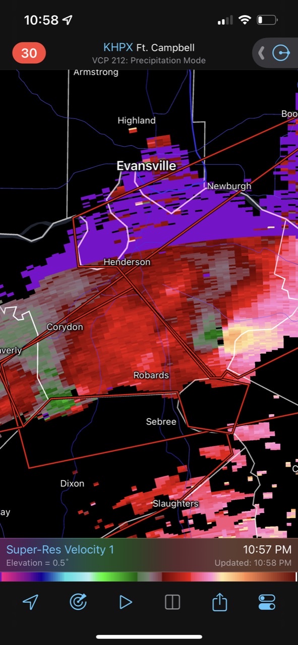
Wish I had a screenshot of the debris ball when it happened. I swear I've never seen one that big and it lingered in the storm for nearly an hour. It was insane. There's not much emergency infrastructure in that area. That area of SW IN is one of the poorest areas in the country.
i saw that too. It probably dropped Sullivan debris on Martinsville.
-
I just had to set sirens off for the tornado warned storm that is now in Howard Co.
-
5 minutes ago, KoalaBeer said:
Pretty speechless that we have this many discreet TOR producing cells still. Robards KY area has two possible tornadoes following just about the same path right behind each other.

This. Never expected this.
-
-
-
That's a freakin' huge area of 10-15% hatched.
-
9 hours ago, cyclone77 said:
Boy I picked a heck of a time to vacation away from the QCA lol. Hopefully get some consolation storms down here but always a bit unnerving being away from your home during a major severe setup.
I forgot that you are on vacation. I was looking forward to videos and pics from ground zero from you. Will you be back home by Tuesday?
-
7 minutes ago, Malacka11 said:
That's what I'm saying. I have a decent amount of stuff in the books for Friday and while I could reschedule all of it to make room for a full day trip to Iowa or WC IL, I'm really not sure I want to do that for the reasons you mentioned. My other option is to be free by 2 and then see if anything remains more discrete in nature in the vicinity but I am currently under the impression that the chance of that is much lower.
I'd vote for option 2 and let 'em come to you. (Well, maybe a short trip just to get into a good position based on radar so you can wave at them as they scream by.)
-
1
-
-
6 hours ago, SchaumburgStormer said:
Shocked. Just shocked… that the warm front got hung up on I-80.
It’s that time of the year where it’s 65 in LaSalle and 45 in DeKalb.
The default surface map for late March/April according to the northern IL and southern MI posters.
-
2
-
2
-
-
Forecast bust here this afternoon. Hit 61° with a predicted high of 53°. It felt great.
-
1 hour ago, Brian D said:
Looks like next week, lots of nickel n diming with snow. Looking forward to record snow season for Duluth, and maybe TH 7NW. Then Spring can come full bore. I'm ready
")
On secondary note, this year, I've been giving obs reports during events to help NWS Duluth know what's going on here TH. We are such a rural area, that there isn't much to go on. My reports on one storm helped them to change a WWA to WSW for my area, because the storm edged a little farther north than anticipated. And yesterday, we had bands of snow showers that got pretty intense at times, so visibility in my email reports (in city blocks) helped them to understand the situation on the ground around here, even flake size is helpful. Or when the radar shows what looks to be light/mod precip, and it's just virga, which happens a lot here because of the dry air over the lake. Just basic obs go a long way.
I know for a fact that the NWS appreciates the real time reports. My Skywarn team and I have been thanked many times over the years for the ground truth reports.
-
1
-
-
Woke up to a surprise inch of snow this morning. It was a surprise to everyone, including me, NWS, INDOT, and the driving public as there have been many accidents along the local interstate.
-
I'll just leave this right here so that our favorite tropical horticulturalist can make proper preparations.

-
1
-
4
-
 3
3
-
-
5 hours ago, rainsucks said:
To be fair, it's been a pretty warm start to the month. These departures will be dropping the next few days tho

You're right, but that's gonna change real soon. I would want those positive anomalies at the end of the month and the negatives ones during the first 10 days of the month.
-
Figures. He has been MIA lately with his Morch calls. lol
-
3
-
-
5 hours ago, SolidIcewx said:
Random question. Is it a good idea to do the skywarn class to become a spotter/observer?
Storm spotting classes is a good way to learn a little meteorology and also to get to know a couple of the mets at your NWS office.
-
 1
1
-
-
3 hours ago, hardypalmguy said:
Are you serious right now? The NWS did a wishy washy flip flopping in the last 12 hours. General public went from "OMG winter storm watch" to "ok no big deal just a WWA" to now "it's a warning now?" and the event hasn't even begun. Too much flip flopping. General public is now tuned out. They are already laughing about it on Facebook.
One more thought, although I'm hijacking the thread. NWS is going to do away with all advisories in '24 or '25, then this argument will be moot. It will either be Watch, Warning, or plain language. If we want to further discuss, let's take it to the banter thread.
-
1
-
1
-
-
26 minutes ago, KokomoWX said:
After heavy rain all day, it has become snow. Sigh.
.Yep. Same here. At least we got it to flip and could see a couple of inches of cement.
-
1
-
-
Have already had multiple upper 50 gusts here, and it looks to continue, maybe even topping 60 in next few hours. I haven't checked my CoCoRaHS gauge, screw that, it's too nasty out there, but guessing that we are pushing an inch and half of rain with at least another half to 3/4s incoming.
-
4
-
-
So dynamic. Multiple 70+ MPH gusts in east-central IL.
-
1
-
-
True torch today.
Indianapolis has officially made it to a record busting 76° as of 330 pm.Maybe more impressive: this is just the 4th date in recorded history that we've gotten to 75° or warmer this early in the year. Other dates: 77° 2/20/2018, 76° 2/25/2000 & 75° 2/11/1999.-
1
-

Spring 2023 Medium/Long Range Discussion
in Lakes/Ohio Valley
Posted
Fortunately for the east side of the forum, we will remain at least around normal tempwise and normal is ~63°-40°. I'll take it.