

IWXwx
-
Posts
6,552 -
Joined
-
Last visited
Content Type
Profiles
Blogs
Forums
American Weather
Media Demo
Store
Gallery
Posts posted by IWXwx
-
-
7 hours ago, Jackstraw said:
It will be really nice to get a perfectly timed pop up storm in this pattern to give a quick cool down and have one enjoyable (moderately anyway) evening. This 80 degrees at midnight crap is still giving me flashbacks. Anything after 6. Anything earlier would suck. They need to come out for localized advisory's for early-mid afternoon showers in this setup. Something like an Emergency Sauna Advisory lol.
Right?! I had a severe-warned around 6 PM that predictably collapsed before it got here. I can't understand IWX warning pulse storms moving 15 MPH unless they are predicting imminent collapse and an associated downburst. Ended up with 0.04" and a virtual sauna as you mentioned.
-
20 minutes ago, Jackstraw said:
Here's a pic of it showing a nicely tilted mini updraft mini SUP that shot up to about 50kft with some low hanging fruit lol. It actually spit out some pea size hail, you can see a bit of a "mini hail core" in that pic lol. Had some weak rotation on it. Enough fruit to get some local kids excited out there chasing scud.
 Some wimpy plains chasing right there lol. Yeah glad it missed us. Hope the ring of fire stays away too next week. My goodness is it gonna get humid around here. Got a feeling the mosquito hatchery is about ready to burst. Still ROFL, Bob Uecker, Ha!!
Pretty nice shot of it. I saw that it had a little rotation on the velocity scans. I'm with you on the ROF. Modals showing it staying north, but as has been mentioned here, it usually ends up Coriolising south. If it does stay north, we'll be in the swamp-ass oven for days on end, so pick your poison.
-
 1
1
-
-
@Jackstraw, it looks like you might get lucky as that random storm slides by juuuuuussssst a little to your northeast (using my Bob Uecker voice.)
-
 1
1
-
-
5 hours ago, Jackstraw said:
Good thing I just bought new tires yesterday. I was trying to get in front of a small cell in front of the main line of storms that was rotating and had a nice wall cloud on it when the gust front from the line caught me from behind. I mean wind went from 0 to 70 or 80 in a flash. This damn tree came down about 50 yards in front of me as I was going about 45mph. I think my old 10 year old tires would've probably killed me lol. Lots of really big trees, limbs, fences, sheds some roofs and barns blown down between Lapel and Muncie. Really strong microburst downdraft through that area as the trees weren't "blowing" sideways it was the wind blowing the trees actually down towards the ground. You could feel the wind coming down like a hammer. Temp went from 85 to 66 in about 90 seconds. One of the weirdest things I've ever been caught in. I drove home and put my underwear in the washer

Got up this morning and we got another 3 in and its still raining. This area is flooded pretty bad.

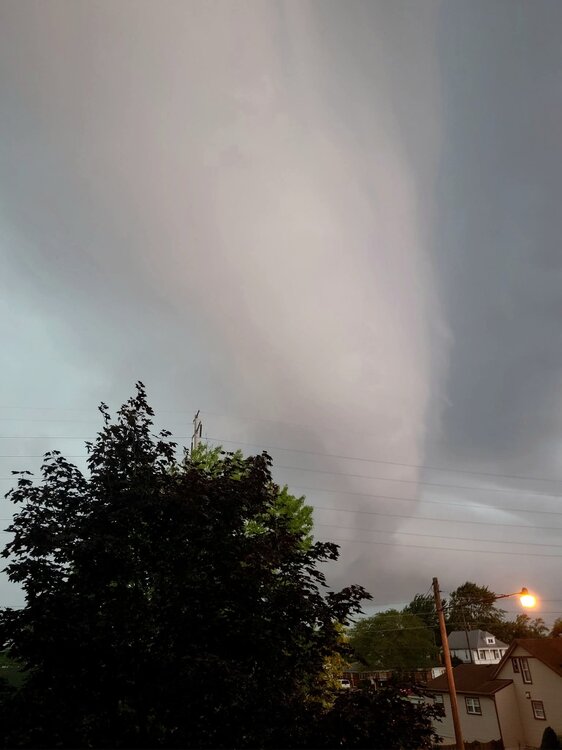
Wow, you're really getting killed by the rain. We had 1.31" yesterday/this morning. We also had a downburst. Lots of trees and powerlines down in about 1 x 4 mile area. I purposely drove into it as I close to it when I saw it on the velocity scan. A tree came down across the road I was on about a minute after I passed it. Here is part of my dashcam video. The first part is the shelf cloud (sped up slightly) and the last part is driving into it. No audio at first and the last couple minutes is me driving into the abyss, to which the video doesn't do justice. Most of the time, I could only go about 10 MPH.
-
4
-
 1
1
-
-
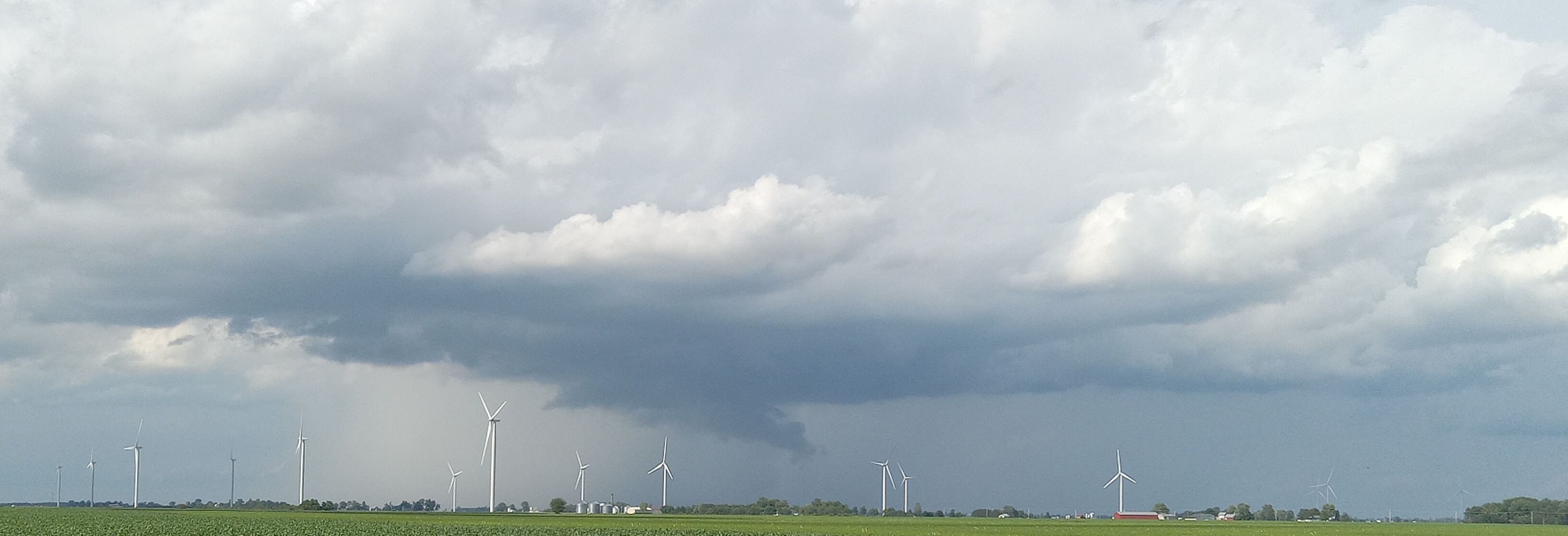
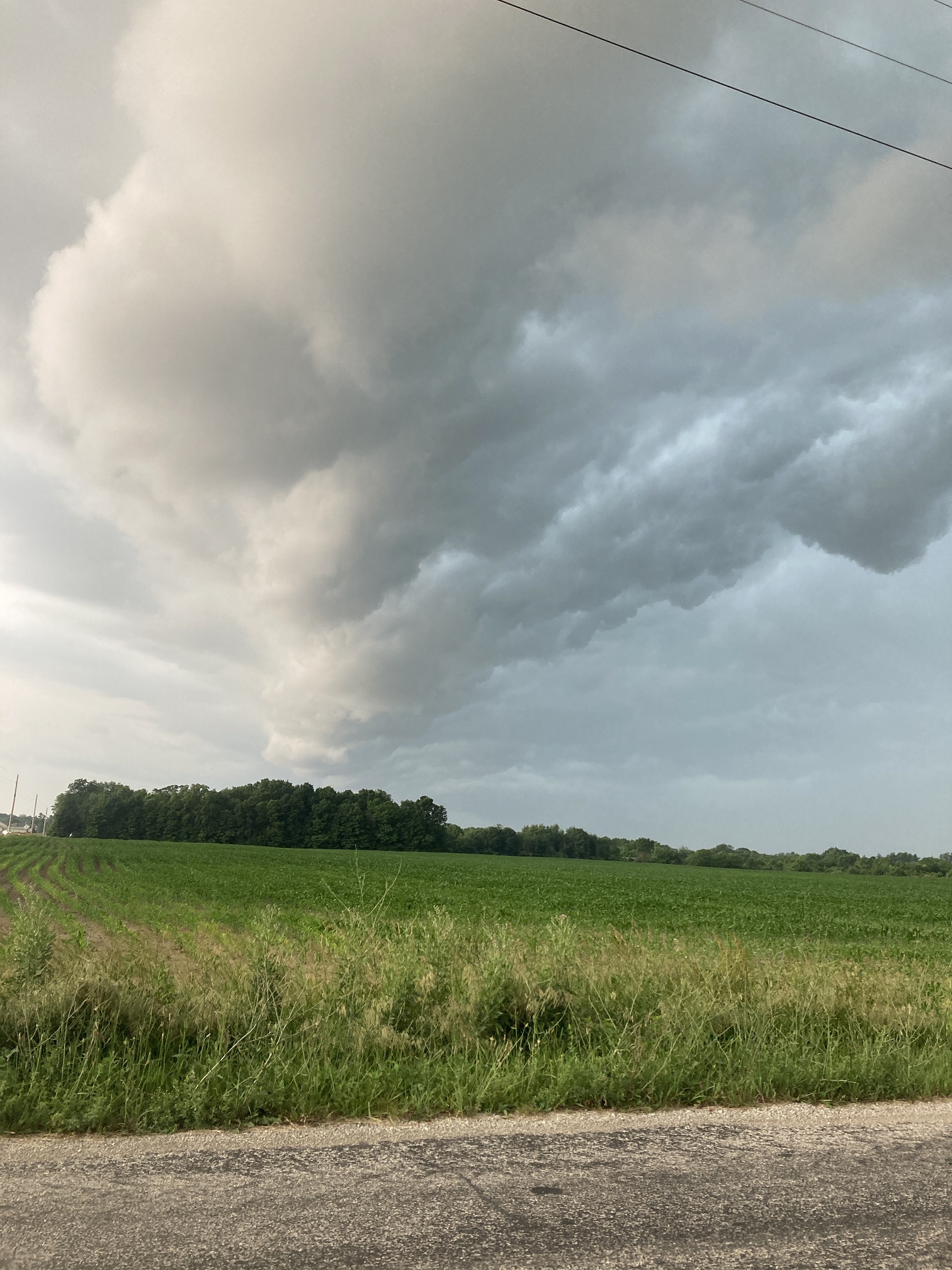
2 hours ago, michsnowfreak said:
Picked up a total of 1.20" rain yesterday, 0.58" of which came from the evening shelf cloud thunderstorm. Definitely the best thunderstorm we have had in a long while. I saw some incredible pics from more open areas, but i was at home so wasn't able to see the cloud expand over an open area in all its glory.
Here's my shelf cloud when it was overhead pic from yesterday

-
2
-
-
7 hours ago, Jackstraw said:
Wouldn't be so bad but its coming in 2 inch shots in 6 hours or less at a time. Gotten a foot over week of fairly steady rain from some tropical drain outs here and it doesnt flood like this. I've watched the radar and we get these heat bubbles in weak flow coming up out of Indy resulting in some fairly deep convective points that have just set on top of us repeatedly and poured. there was another this afternoon but luckily it was down just South of Anderson. Dropped 2 in in 4 hours there. Same type of setup. We've lost 50% of the green space between here and Indy in the last 15 years. They are paving and concreting their way N at a rapid pace. Its really expanding the heat island effect here.
Some models spitting out another 1 to 2 inches here by Thursday AM. I hope it comes slow
Off topic but you are right about expansion north of Indy. I remember when you could drive south to within a mile of 465 and have corn fields. Now it's concrete well north of Westfield and Noblesville, and quickly approaching Pendleton.
-
6 hours ago, Jackstraw said:
It's starting to get biblical here. Another 2.5in last night. I have serious flood issues now. Creeks over its banks. Waters about 6ft from the back deck. I just dropped 150ft of new fence posts Sun/Mon. Those are damn near floating, gonna have to be redone damn it. Fields around here are drowning. Kinda wacky as its fairly isolated to just this area. 9 inches since Friday. Thats half a summers worth in 4 days. Man the muggles are gonna suck this weekend when we start hitting 90/70 dews. South Carolina low country is chasing me. Had enough of this shit.
Wow, quite a difference in a short distance. I've had less than half of that all month.
-
13 hours ago, Jackstraw said:
We have been getting pummeled with rain today. 3.5 inches in the gauge and and its still shaking out sheets of rain. Training off of the N Indy to the dreaded Carmel area urban heat island off to the NNE all day. Line came through earlier and it dissipated except the train from N Indy to right over me. It just won't stop. Like the Pacers
")
We've had a sharp cutoff up here. As of 7AM, the southern part of the county has had well over 3", and just a few miles north in Huntington, .13"
-
2.89" of rain overnight through 7 AM (Eastern time) and still raining. Feast or famine.
-
1
-
-
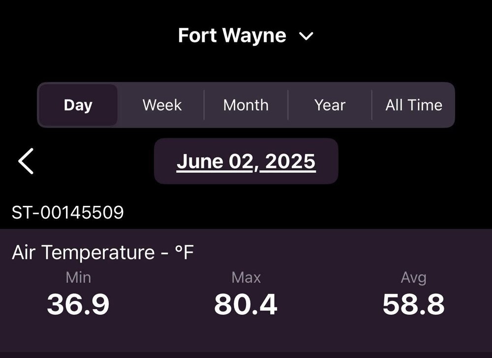
We did have a nice diurnal swing today, but not over 100 degrees.
-
3
-
-
26 minutes ago, madwx said:
Forecast was off. Imagine trying to predict tornadoes when the only info you got before convective initiation was when a trough hit the west coast
That's what happens when some imbeciles decide to take a meat clever to NOAA personnel.
-
2
-
 1
1
-
-
34 minutes ago, A-L-E-K said:
Stay downstate.
-
Looks like I'll be heading northwest today and south tomorrow
-
Got hammered between 6:30-6:50 (EDT) this morning. Caught 0.53" in that timeframe, with pea sized hail and some great lightning. The hardest I've seen it rain in a long time. Nice way to wake up on a Saturday morning.
-
2
-
-
-
On 3/23/2025 at 10:56 AM, King James said:
Another day, another wind advisory.
It wasn't your imagination. https://www.msn.com/en-us/general/general/the-u-s-just-had-its-windiest-start-to-spring-in-nearly-50-years/ar-AA1CvYrA?utm_source=GetKim.com
-
1
-
 1
1
-
-
2024-'25 The winter of the mid-south.
-
 1
1
-
-
14 hours ago, TheClimateChanger said:
Not the same. Even in colonial times, they had fireplaces to keep warm. And it cost nothing to make a fire.
...except hard work.
-
1
-
-
With over 2 1/2" (over an inch and a half in the past 24 hrs.) of rain here in the past week and another 2-3" forecast for Friday-Sunday, we won't have to worry about drought for awhile. I may not get into my garden until May if this keeps up.
At least it's not going to be like the Ohio River valley. They might need boats to travel.
-
9 minutes ago, Jackstraw said:
Pfffft...Fooey... for MBY. Just as I thought. Just as is always. Big scary photogenic shelf cloud, a clap of thunder and a gust of wind. As always everything splits North and South.
Maybe next time..... for the 100th time lol.
Same here. I've had stronger storms that weren't even warned.
-
1
-
-
On 3/21/2025 at 10:06 AM, cyclone77 said:
Snow total at MLI ended up being 0.8", 0.5" at DVN. MLI now up to 8.2" for the season, with 1.6" futility buffer remaining.
Lawns are starting to green up now with the recent rains/warmth.
I'm feeling your pain. My last two years totals put together are eight inches under my yearly average!!
-
2
-
-
8 hours ago, sbnwx85 said:
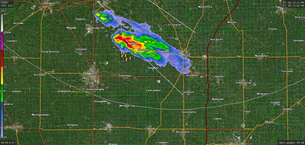
Reports of large trees down, house and barn damaged in the same area and time of this CC drop in Fulton and Kosciusko County, IN. No Tornado Warning.
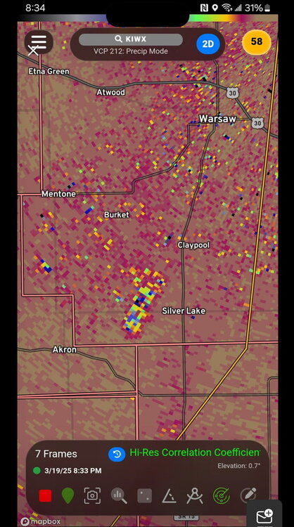
I was on NWSChat when that happened. IWX said that it wasn't lining up with velocity/reflectivity scans and speculated that it might have been a microburst.
-
3
-
-
22 hours ago, King James said:
I’m sure the spreadsheets say otherwise, but regarding drought, there have been so many brush fires out by me to start this spring
Locally this past fall, winter, and now spring have been extremely dry. Couple that with some very high winds, there have been sirens quite often from neighboring towns heading off to the plume of smoke off in the distance.
Burning leaves, even when things have been damp, is no problem at all. It’s almost scary to fire up the Smokey Joe right now for some brats.
Just a very dry period locally and looking forward to a wet and humid spring to bring everything back to life out my wayWe had 6 brush/field fires in our county from 4PM Tuesday-4PM yesterday.
-
1
-
-
Nocturnal passage FTL. Clowns to the left of me, jokers to the right, here I am
-
2
-
1
-
1
-


June 2025 General Discussion
in Lakes/Ohio Valley
Posted
Monsoonal rain here today too. Picked up a quick 3/4". Now the sun's back out.